Fern Canyon Trail
in Prairie Creek Redwoods State Park
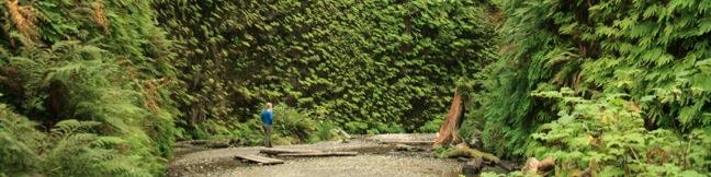
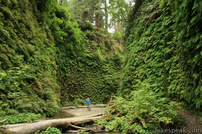
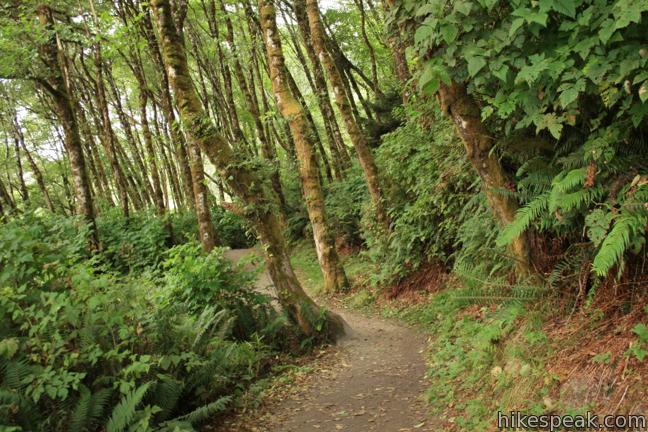
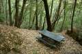
If you’ve never walked between fifty foot walls of ferns, than you haven’t experienced a hike like Fern Canyon Trail. This short trek transports you through a cool moist canyon with fortress-like walls covered top to bottom in enchanting ferns. The trail starts just inland from a vacant stretch of the North Coast of California, and then turns inland into the lush shady forest housing Fern Canyon. The hike can be done as a 1.1-mile lollipop loop with 150 feet of elevation gain, but it is most enjoyable as a one mile out and back with 75 feet of elevation gain. Turn around at the top of Fern Canyon and replay the most exciting portion of the hike.
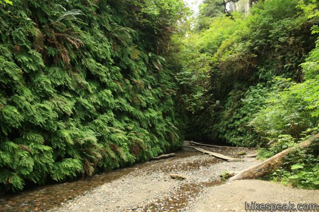
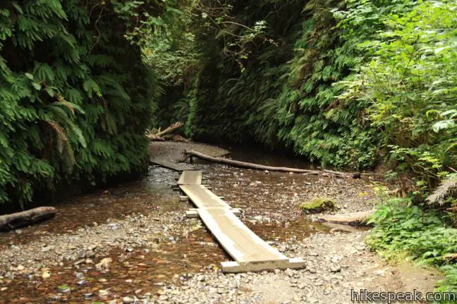
From the Fern Canyon Day Use Parking Area north of Gold Bluffs Beach Campground, proceed north on California Coastal Trail to the turnoff for Fern Canyon. Hang a right and make your way up the center of the fern furnished canyon. Expect your footwear to get a little wet from here. This trail crisscrosses a steady creek, and while there are several wooden footbridges, it is hard to escape without at least one wet toe. Wear scandals, and enjoy.
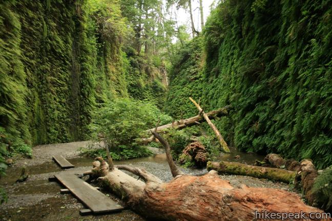
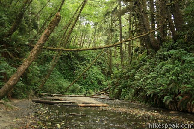
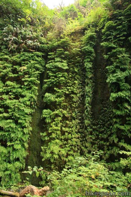
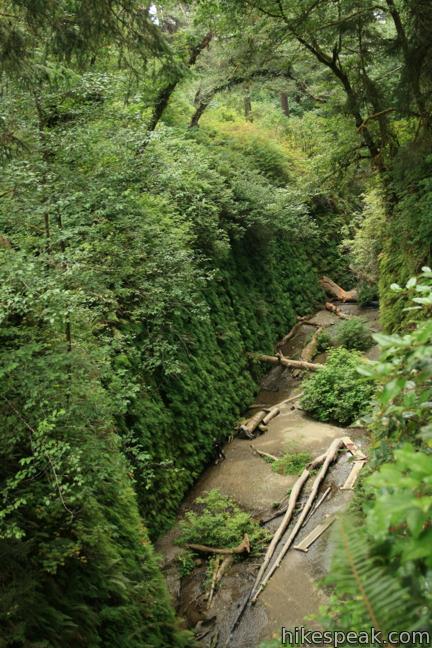
Fern Canyon narrows to a width of less than thirty feet. The level bottom is boxed in by stout vertical walls. Water seeps from behind the tapestry of ferns to create a lush microclimate. You might find hiking up Fern Canyon like walking through a hedge maze, but there are no crossroads to be concerned with. The course is clear and the only obstacles are the meandering creek and downed trees strewn around the canyon.
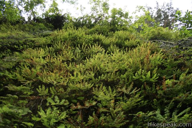
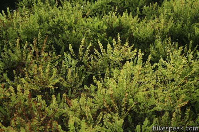
Eight different species of ferns thrive in Fern Canyon. The easiest to spot is five-finger fern. Not only is it everywhere in the canyon, but it has an unmistakable multi-finger design. Sworn fern is also common. It has a pointy triangular shape, and can be spotted at the base of the canyon walls in low-light areas. This fern is common in redwood forests throughout the region.
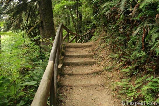
After a quarter mile in a fantasy world of ferns, the trail exits the left side of the canyon up a series of wooden steps. Turn around here and head back down the canyon, or of you prefer, see what the forest above has to offer.
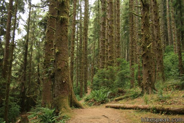
Hiking up out of the canyon, go a tenth of a mile to Friendship Ridge Trail and turn left. The next 1/4 mile of trail goes through pristine pine forest back to the mouth of Fern Canyon. A short distance from the junction, pass an unmarked spur trail on the left that crosses a small meadow to the rim of Fern Canyon. You can enjoy a nice view down the trench from here before backtracking to the main trail.
Fern Canyon Trail provides a short unique hike. The trailhead has bathrooms and beach access. Camping is nearby. Dogs are not allowed on trails in Prairie Creek Redwoods State Park. There is an $8 day use fee to enter the park but no permit is required to explore Fern Canyon. The dirt road between the 101 and the trailhead passes through a redwood forest that enhances the experience of visiting Fern Canyon.
Seasonal note: Fern Canyon may disappoint winter visitors. The ferns turn brown and the creek expands, making the canyon less enjoyable to walk up.
Directions to the Trailhead
- From Highway 101, 2.5 miles north of Orick and 18 miles south of Klamath, turn west on to Davidson Road.
- Follow this road for four miles through a redwood forest to the park entrance station.
- Continue another two miles to the trailhead at the end of Gold Bluffs Beach Road.
Trailhead Location
Trailhead address: Gold Bluffs Beach Road, Prairie Creek Redwoods State Park, Orick, CA 95555
Trailhead coordinates: 41.400618, -124.0657 (41° 24′ 02.22″N 124° 03′ 56.55″W)
You may also view a regional map of surrounding Northern California trails and campgrounds.
 | Yurok Loop and Hidden Beach This 2.25-mile hike explores a rugged and beautiful area of California's north coast, combining Yurok Loop Trail and the Hidden Beach Section of Coastal Trail to visit beaches, forests, and ocean vistas. |
 | Stout Memorial Grove This 0.55-mile hike explores an old growth grove of coastal redwoods in Jedediah Smith Redwoods State Park. |
 | Founders Grove Nature Trail This 0.5 mile loop explores an ancient grove honoring the founders of the Save-the-Redwoods League in Humboldt Redwoods State Park. |
 | Grieg-French-Bell Trail This half-mile loop in Humboldt Redwoods State Park explores redwood groves dedicated to Grieg, French, and Bell, crossing ground covered in redwood sorrel to visit the Girdled Tree, which had its bark stripped away and sent to San Francisco. |
 | Drury-Chaney Loop Trail This 2.4-mile lollipop loop provides an easy and enchanting hike through redwood trees at the north end of Humboldt Redwoods State Park. |
 | Gould Grove Trail This half mile loop explores an old growth redwood forest across from the visitor center in Humboldt Redwoods State Park. |
 | Woodland Trail This 1.25-mile loop explores patches of redwoods surrounded by a shaded oak forest in Richardson Grove Redwoods State Park. |
 | Durphy Creek Trail - Tan Oak Springs Trail - Lookout Point Loop This 3.75-mile loop climbs 1,000 feet to a forest ridge before descending to Lookout Point, where you can enjoy an unimpressive view to the south. |
 | More hikes in Northern California Explore other trails in Northern California, including hikes in coastal parks and around Mount Shasta. |
Common Questions about Fern Canyon Trail in Prairie Creek Redwoods State Park
- Is the trail open?
- Yes. You should expect to find that Fern Canyon Trail is open. There are no recent reports of trail closures. If you discover that the trail is closed, please help your fellow hikers by reporting a closure.
- Do I need a permit for this hike?
- Yes. State Park Entrance Fee.
- How much time does this hike take?
- It takes approximately 30 minutes to hike Fern Canyon Trail. Individual hiking times vary. Add extra time for breaks and taking in the views.
- How long is this hike?
- The hike to Fern Canyon Trail is a 1.1 mile lollipop loop with 75 feet of elevation change.
- Are dogs allowed on this trail?
- No, dogs are likely not allowed on Fern Canyon Trail. The trail is primarily open to hikers.
- Is Fern Canyon Trail good for kids?
- Yes, this hike is likely suitable for children. It is relatively short (1.1 miles) with manageable elevation gain.
- Where is the trailhead located?
- The trailhead for Fern Canyon Trail is located in Orick, CA.
Trailhead Address:
Gold Bluffs Beach Road
Orick, CA 95555
Trailhead Coordinates:
41.400618, -124.0657 - What are the driving directions to the start of the hike?
To get to the trailhead: From Highway 101, 2.5 miles north of Orick and 18 miles south of Klamath, turn west on to Davidson Road. Follow this road for four miles through a redwood forest to the park entrance station. Continue another two miles to the trailhead at the end of Gold Bluffs Beach Road.
View custom Google Maps directions from your current location.
- Are there other trails near Fern Canyon Trail?
- Yes, you can find other nearby hikes using the Hikespeak Hike Finder Map.

28 Comments on Fern Canyon Trail in Prairie Creek Redwoods State Park
What hikers are saying:
✨ Generated summary of user commentsHikers describe this lush canyon as a beautiful destination that occasionally feels like a crowded theme park due to its popularity. Accessing the trailhead is challenging because the road contains many deep potholes and a stream crossing that may require a high-clearance vehicle. Joe warns that heavy traffic and large groups can impact the serene atmosphere.
“More like a ferny Disneyland.” Jump to comment ↓
where are there camping spots close to this? and what are the hours that the trail is open?
The closest camping spots are at Gold Bluffs Beach in Prairie Creek Redwoods State Park. They are only open during the summer, usually from Memorial to Labor Day and are always first-come-first-serve. The next closest and within the same park is at Elk Prairie campground, which is open year round. During the summer it is on reservation and the rest of the year it is first-come-first-serve. https://redwoods.info/showrecord.asp?id=1723
Can anyone tell me if this is a pet-friendly trail? I’m heading up that way in a couple of weeks and would love to know.
It says that no dogs are allowed on the trails
State parks usually do not allow dogs in them. The dogs tend to disrupt the wild life. Maybe not the little ones, but that’s the rule. Some dog owners don’t get keeping their dogs on a leash.
I would love to hike and see fern canyon. I plan on camping with my dog though. Is there any trails that are dog friendly? If not, how far from the day parking is the walls of fern? This is on my bucket list and I dislike the fact that I can’t bring my hiking buddy with me.
California state parks do not allow dogs. They love whacky regulations. Go to Oregon every state park I have visited allow dogs.
This would of been nice to see
This area is known for being anti dog areas. Mountain lions and bobcat in the area have been known to track and attack dogs.
No trains in the area.
Dogs are not allowed period! The reason most hiking trails are sterile is because they allow dogs on them. Dog owners think they are unique (among the other 200 people a day who want their dog to play) and let their dog off leash,
Dogs are dogs, if they see anything move they want to play with it, sniff it, lick it, bite it and…eat it!
This trail is unique because dogs haven’t impacted it. In today’s world nature has a hard time surviving. Let’s give her a break and close more trails to dogs. Trails could actually recover.
I agree on the dog ban. The writer is correct-dogs are allowed to run free to the dismay of the rest of us. You can’t take your dog everywhere, get it?
By your logic, close it to humans including children. Humans are the ultimate problems. Grafiti, carving, gathering.
I don’t know what type of dogs you run into or meet, but as a Nature Enthusiast, my dog doesn’t have prey drive (which means he does NOT run off chasing animals, trying to eat or lick things) and he enjoys our many hikes. We pick up after him and he’s ALWAYS on leash. However, not every HUMAN dog owner is respectable like some of us. Many trails are closed off for restoration is generally due to HUMANS stomping around trying to make their own paths and not respecting nature and leaving their trash behind. Let’s be real and not blame animals for human doings.
Right. And the humans who left wooden planks all over the trail so hikers like you wouldn’t have to cry about getting your feet wet don’t make any kind of impact. Just what I want to see when I’m out hiking in an otherwise beautiful place like this is constant reminders of human impact around every corner.
[…] Fern Canyon Trail […]
Does anyone have the correct phone number to Fern Canyon park? The one I’m dialing – 707-465-7354 – is not working. I was trying to check and see if it was too rainy/flooded to enter the park by car.
Their website says (707)488-2039. Good luck!
What is the weather like in December? Ok for camping? We’re planning a Christmas week trip and thought this might be fun.Thanks for your help.
Likely quite cool and rainy!
Does this park have the train ride?
No trains in the area.
[…] https://www.hikespeak.com/trails/fern-canyon-hike-prairie-creek-redwoods-state-park/ […]
[…] Fern Canyon Trail […]
What’s the weather like end of September and what’s the best place to stay nearby?
I came to this place to check it out on April 12. It rained a lot and walking the stream upward to the canyon required rain boots which I did not have so I could not check out the fern canyon and I was so close too. I should have just ford the river but time was also a factor as well as we were there around 6pm; it was my bad on my part there.
But the biggest concern is driving there. Someone needs to cover up the many, MANY potholes on this road as me and others driving there was afraid of damaging something under my car and made getting there SO slow and my brakes constantly being used with all the stop and go. Someone also needs to put a bridge of some sort on the stream that appears on the road up to fern canyon. My car is a RAV4 so it’s raised higher but does not have 4WD.
The lack of understanding for those of us who have “man’s best friend,” is deplorable. The meaning of responsibility and environmental impact isn’t lost on the choir, but on those pointing fingers ignorant of their own actions. Thank you for ruining it for those of us paying attention.
Last time I was there it was wall-to-wall people, many families with small children, people walking with boomboxes blaring, a massive traffic jam in the parking lot. Not exactly the experience promised by the photos. More like a ferny Disneyland.
the fern canyon beautiful. the comments some negative. I like to know how to get from La to the canyon is there any other way to get there beside driven ?