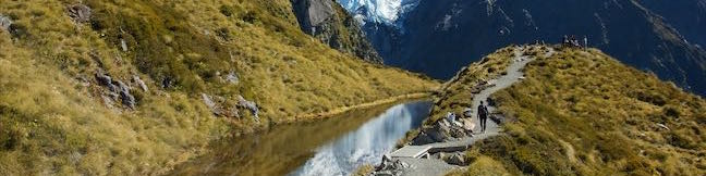
Millennium Walk Avalanche Creek Waterfall Arthur's Pass National Park Hike Avalanche Creek Falls Arthur's Pass Hiking Track New Zealand
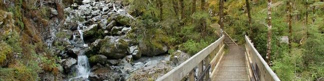
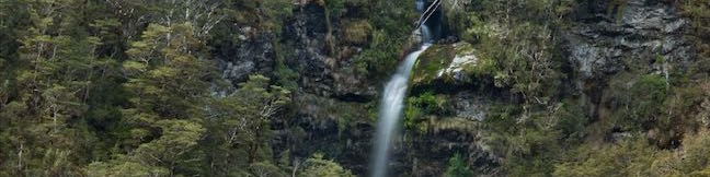
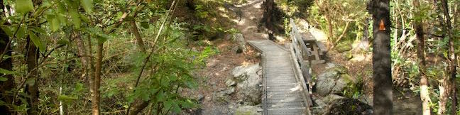
Millennium Walk is a very short hike from the visitor center for Arthur's Pass National Park to a viewing platform alongside Avalanche Creek Waterfall. This walk is 500 meters round trip with only a few meters of elevation change, covered over stone steps at the end of the walk. If you stop by the visitor center in Arthur's Pass Village, this short walk to the waterfall is well worth your... Read more.
By: Published: Last updated: May 6, 2017
Bridal Veil Falls Lookout Arthur's Pass National Park Hike Arthur's Pass Walking Track Jacks Hut to Bridal Veil Falls Lookout Hiking Track New Zealand
Bridal Veil Falls is a 108-meter (350-foot) waterfall dropping into a beech tree-shrouded canyon near Arthur's Pass Village. While a walking track doesn't go to the base of Bridal Veil Falls, you can get a good look at the waterfall, along with the village and surrounding peaks, from Bridal Veil Falls Lookout on Arthur's Pass Walking Track. Arthur's Pass Walking Track is over three... Read more.
OK! Add to trails I’ve hiked
OK! Remove from my hikes
Tagged with · Arthur's Pass Village · New Zealand Department of Conservation · New Zealand National Parks · Waterfalls · Arthur's Pass National Park
Distance: 2.5 kilometers / 1.1 miles · Elevation change: 75 meters / 245 feet
By: Published: Last updated: May 6, 2017
Bridal Veil Falls Lookout Arthur's Pass National Park Hike Arthur's Pass Walking Track Arthur's Pass Village to Bridal Veil Falls Lookout Hiking Track New Zealand
Bridal Veil Falls is a 108-meter (350-foot) waterfall dropping into a beech tree-shrouded canyon near Arthur's Pass Village. While a walking track doesn't go to the base of Bridal Veil Falls, you can get a good look at the waterfall, along with the village and surrounding peaks, from Bridal Veil Falls Lookout on Arthur's Pass Walking Track. Arthur's Pass Walking Track is over three... Read more.
OK! Add to trails I’ve hiked
OK! Add to trails I want to hike
Tagged with · Arthur's Pass Village · Free Trails · New Zealand Department of Conservation · New Zealand National Parks · Waterfalls · Arthur's Pass National Park
Distance: 1.8 kilometers / 1.1 miles · Elevation change: 68 meters / 225 feet
By: Published: Last updated: May 6, 2017
Kereru Loop Hike Mt Thomas Forest Wooded Gully Track Kereru Track Red Pine Track Mount Thomas Forest Conservation Area New Zealand
The shortest hike in Mount Thomas Forest is Kereru Loop, a 2.45 kilometer (1.5-mile) circuit that starts from Wooded Gully Campground. The loop employs three trails, Wooded Gully Track, Kereru Track, and Red Pine Track, for a quick walk through the forest. The loop doesn't offer any grand vistas and is highlighted by picnic spot along Wooded Gully Stream. The hike takes less than an hour... Read more.
OK! Add to trails I’ve hiked
OK! Add to trails I want to hike
Tagged with · Creeks · Free Trails · Mount Thomas Forest Conservation Area · New Zealand Department of Conservation · Okuku
Distance: 2.45 kilometers / 1.5 miles · Elevation change: 95 meters / 310 feet
By: Published: Last updated: May 6, 2017
Kura Tawhiti Castle Hill Conservation Area Hike New Zealand Canterbury
Not far from Arthur's Pass National Park in the Canterbury Region of New Zealand, you'll come across an alluring playground of limestone boulders in Kura Tawhiti / Castle Hill Conservation Area. Mountain climbers have fun scaling its many misshapen boulders and hikers will enjoy venturing through the area as well. A level 600-meter long track leads to the foot of a grassy hill covered with... Read more.
OK! Add to trails I’ve hiked
OK! Add to trails I want to hike
Tagged with · Bouldering · Castle Hill · Free Trails · Kura Tawhiti / Castle Hill Conservation Area · Memorials · New Zealand Department of Conservation
Distance: 2.6 kilometers / 1.6 miles · Elevation change: 65 meters / 215 feet
By: Published: Last updated: May 6, 2017
Las Flores Motorway hike Mount Thom Las Flores Motorway Trail Verdugo Mountains Glendale California Hike
Las Flores Motorway weaves its way up ridges on the southeast end of the Verdugo Mountains in Glendale. The wide dirt trail blooms when it reaches Mount Thom, a 2,460-foot summit with panoramic views over surrounding city-flanked mountain ranges and the skyline of downtown Los Angeles. Las Flores Motorway gains 1,220 feet in 2.5 miles to join Beaudry Motorway just below the summit. Strut... Read more.
OK! Add to trails I’ve hiked
OK! Add to trails I want to hike
Tagged with · Free Trails · Glendale · Summits · Dog-Friendly Trails · Mountain Biking Trails · Verdugo Mountains
Distance: 5.3 miles · Elevation change: 1260 feet
By: Published: Last updated: December 7, 2018
Malibu Lagoon State Beach Surfer's Express Trail Surfrider Beach Malibu Pier Malibu Creek Estuary Beach Walk Malibu California
Recently restored Malibu Lagoon State Beach is a lovely place to walk around an estuary and stroll along the beach. Take a walking path to overlooks around shorebird-filled wetlands and connect to Surfrider Beach, a world famous point break where Malibu Creek meets the Pacific Ocean. Sinking your toes in the sand, you can make your way east to Malibu Pier. In all, you'll stretch your legs... Read more.
OK! Add to trails I’ve hiked
OK! Add to trails I want to hike
Tagged with · Beaches · California State Parks · Malibu · Malibu Lagoon State Beach · Wheelchair-Friendly
Distance: 2 miles · Elevation change: 10 feet
By: Published: Last updated: October 8, 2024
Mount Ollivier from Mueller Hut Aoraki Mount Cook National Park Southern Alps Summit New Zealand
Mount Ollivier is a 1,933-meter tall peak in the Sealy Range of the Southern Alps in Aoraki Mount Cook National Park. In 1939, Sir Edmond Hillary summited the mountain in what is recognized as his first major climb. (He went on to bag some other noteworthy peaks as well...) To get to the top of Mount Ollivier, you will first need to make your way to Mueller Hut, which is accomplished by... Read more.
OK! Add to trails I’ve hiked
OK! Add to trails I want to hike
Tagged with · Mount Cook · New Zealand Department of Conservation · New Zealand National Parks · Off Trail · Summits · Aoraki Mount Cook National Park
Distance: 1.2 kilometers / 0.75 miles · Elevation change: 125 meters / 410 feet
By: Published: Last updated: May 6, 2017
Mueller Hut Route Aoraki Mount Cook National Park Viewpoint Mueller Hut Climb Southern Alps Hike New Zealand Sealy Range
Mueller Hut is one of the most spectacular destinations for a day hike or overnight trek in Aoraki Mount Cook National Park (and perhaps all of New Zealand). Reaching the hut is no simple walk in the park, demanding an ascent of over one thousand meters in just over five kilometers. They truly don't come much steeper than this and that challenge is part of the trek's appeal. Kick things... Read more.
OK! Add to trails I’ve hiked
OK! Add to trails I want to hike
Tagged with · Huts · Mount Cook · New Zealand Department of Conservation · New Zealand National Parks · Southern Alps · Aoraki Mount Cook National Park
Distance: 10.5 kilometers / 6.5 miles · Elevation change: 1045 meters / 3425 feet
By: Published: Last updated: April 4, 2020
Sealy Tarns Track Aoraki Mount Cook National Park Sealy Tarns Stairway Walk Southern Alps Mt Cook Hike New Zealand Walk
In a park full of massive features, it might surprise you to learn that a couple small ponds are a premier hiking destination. The Sealy Tarns are located 500 meters up a steep mountainside, with mirror-like water that can reflect nearby mountains like Mount Sefton and Mount Cook. Sealy Tarns Track is not very long, but it is very steep, coming it at 5.8 kilometers round trip with 547... Read more.
OK! Add to trails I’ve hiked
OK! Add to trails I want to hike
Tagged with · Free Trails · Mount Cook · New Zealand Department of Conservation · New Zealand National Parks · Southern Alps · Aoraki Mount Cook National Park
Distance: 5.8 kilometers / 3.6 miles · Elevation change: 547 meters / 1795 feet
By: Published: Last updated: May 6, 2017