Half Dome hike Yosemite National Park John Muir Trail Half Dome Trail
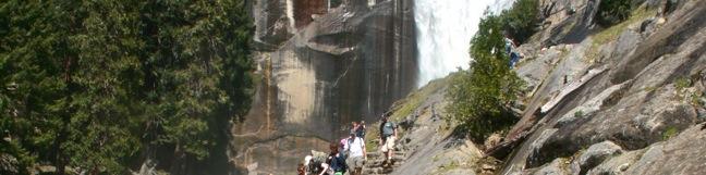
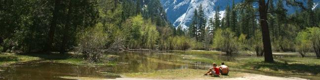
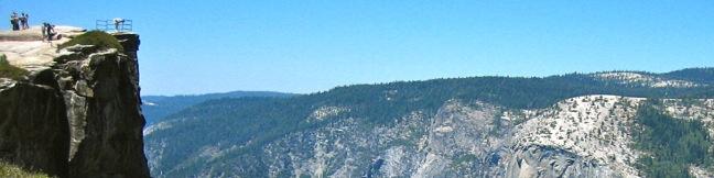
It might be half a dome, but it's a full day's hike - 16 miles round trip from Yosemite Valley with 4,800 feet of elevation gain. Is Yosemite's much heralded bucket-list hike worth all the hoopla? You bet it is. Half Dome is an iconic element of the Yosemite landscape and the trail to its summit is a one of a kind. The hike up Half Dome is a major challenge (and a major reward). ...Read more.
My Hikes: Completed hikeA green icon of shows a picture of a landscape with a check mark in the upper right corner, signifying that this is a hike you would like to put on your completed list.OK! Add to trails I've hiked
My Hikes: Want to hikeA green icon of shows a picture of a landscape with a heart in the upper right corner, signifying that this is a hike you would like to put on your to-do list.OK! Add to trails I want to hike
TagsA green icon depicting a tags represents a list of words and phrases that this content is tagged with Tagged with · Backpacking · John Muir Trail · National Parks · Summits · Waterfalls · Yosemite Valley
Hike DistanceA green icon of a hiker used to label information about the length of the hike Distance: 16 miles · Elevation change: 4800 feet
By: Published: July 10, 2011 Last updated: May 13, 2025
Mist Trail Vernal Fall hike Yosemite National Park Nevada Falls John Muir Trail Loop
On the path to Half Dome, Yosemite's most imposing bucket list hike, are two impressive waterfalls coursing down the Merced River. The Mist Trail provides the steepest most intimate experience of Vernal Fall and Nevada Fall. John Muir Trail takes a more gradual route to the top of Nevada Fall and is the most practical route for those continuing to Half Dome. ...Read more.
My Hikes: Completed hikeA green icon of shows a picture of a landscape with a check mark in the upper right corner, signifying that this is a hike you would like to put on your completed list.OK! Add to trails I've hiked
My Hikes: Want to hikeA green icon of shows a picture of a landscape with a heart in the upper right corner, signifying that this is a hike you would like to put on your to-do list.OK! Add to trails I want to hike
TagsA green icon depicting a tags represents a list of words and phrases that this content is tagged with Tagged with · John Muir Trail · National Parks · Waterfalls · Yosemite Valley
Hike DistanceA green icon of a hiker used to label information about the length of the hike Distance: 6.1 miles · Elevation change: 1925 feet
By: Published: June 23, 2011 Last updated: May 13, 2025
Mirror Lake Trail Royal Arches Cascade hike Yosemite National Park easy hiking Yosemite Valley reflective pool bike path
Wedged between the granite walls of Half Dome and North Dome on the east end of Yosemite Valley, visit an enticing body of water that doubles the Yosemite splendor. Mirror Lake, which is not actually a lake but rather a shallow seasonal pool, is famous for its reflective beauty. Due to it's popularity and easy-to-reach-ness, a few trails lead to Mirror Lake. ...Read more.
My Hikes: Completed hikeA green icon of shows a picture of a landscape with a check mark in the upper right corner, signifying that this is a hike you would like to put on your completed list.OK! Add to trails I've hiked
My Hikes: Want to hikeA green icon of shows a picture of a landscape with a heart in the upper right corner, signifying that this is a hike you would like to put on your to-do list.OK! Add to trails I want to hike
TagsA green icon depicting a tags represents a list of words and phrases that this content is tagged with Tagged with · Creeks · Lakes · National Parks · Yosemite Valley
Hike DistanceA green icon of a hiker used to label information about the length of the hike Distance: 2.8 miles · Elevation change: 100 feet
By: Published: June 7, 2011 Last updated: May 13, 2025
Yosemite Fall Lower Yosemite Falls waterfall hike Yosemite National Park
A pair of paved paths lead to a viewing bridge below Lower Yosemite Fall, creating a 1.2-mile loop to the foot of the tallest waterfall in North America, and the fifth tallest in the world. The western side of the loop is laid out in a line with Yosemite Falls to provide absolutely eye-popping, jaw-dropping, imagination-defying, awe-inspiring views of the 2,425-foot waterfall. ...Read more.
My Hikes: Completed hikeA green icon of shows a picture of a landscape with a check mark in the upper right corner, signifying that this is a hike you would like to put on your completed list.OK! Add to trails I've hiked
My Hikes: Want to hikeA green icon of shows a picture of a landscape with a heart in the upper right corner, signifying that this is a hike you would like to put on your to-do list.OK! Add to trails I want to hike
TagsA green icon depicting a tags represents a list of words and phrases that this content is tagged with Tagged with · National Parks · Waterfalls · Wheelchair-Friendly · Yosemite Valley
Hike DistanceA green icon of a hiker used to label information about the length of the hike Distance: 1.2 miles · Elevation change: 100 feet
By: Published: May 26, 2011 Last updated: January 31, 2018
Taft Point Yosemite National Park hike Glacier Point Road Trail
The panoramic view from Taft Point and the rock fissures nearby provide a rewarding 2-mile hike. The dirt single track descends just 250 feet to an outcropping on the south wall of Yosemite Valley that overlooks El Capitan and Yosemite Falls. Yosemite Fall from Taft Point From the trailhead, turn left and begin a peaceful walk through a big pine forest bordering a high elevation meadow. ...Read more.
My Hikes: Completed hikeA green icon of shows a picture of a landscape with a check mark in the upper right corner, signifying that this is a hike you would like to put on your completed list.OK! Add to trails I've hiked
My Hikes: Want to hikeA green icon of shows a picture of a landscape with a heart in the upper right corner, signifying that this is a hike you would like to put on your to-do list.OK! Add to trails I want to hike
TagsA green icon depicting a tags represents a list of words and phrases that this content is tagged with Tagged with · National Parks · Yosemite Valley
Hike DistanceA green icon of a hiker used to label information about the length of the hike Distance: 2 miles · Elevation change: 250 feet
By: Published: May 25, 2011 Last updated: January 30, 2018