Click here to see a non-mobile list of hikes in Nevada
These hikes in Nevada are located around Lake Tahoe and in two parks near Las Vegas, Valley of Fire State Park and Red Rock Canyon National Conservation Area.
Lake Tahoe
 | Cave Rock Trail This 0.9-mile hike above the east shore of Lake Tahoe finishes with a scramble up a rocky crown that has panoramic views. |
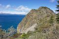
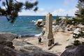 | Chimney Beach Trail This 1.1-hike descends to a scenic and unique cove on the shore of Lake Tahoe that houses a stand-along chimney lingering from an old cabin. |
Valley of Fire State Park
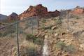
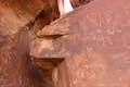 | Atlatl Rock Step right up to see Native American rock art on this 0.1-mile trail with stairs up a rock face to a collection of petroglyphs. |
 | Balancing Rock This 0.25-mile hike, which begins next to the Valley of Fire State Park Visitor Center, approaches a rock formation that appears to stand with a bit of magic. |
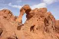 | Elephant Rock Trail This 0.3-mile hike at the east entrance of Valley of Fire State Park leads to a sandstone formation resembling an elephant with a unique natural arch for a trunk. |
 | Fire Wave Trail This 1.5-mile hike reaches a sensational striped creation where a slickrock depression is painted in waves of orange and beige. |
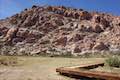
 | Petrified Logs Loop This 0.3-mile hike gets close to petrified logs on the desert floor passing panels that explain how wood is petrified. |
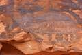 | Petroglyph Canyon Trail to Mouse’s Tank This 0.75-mile hike travels down a sandy path lined with petroglyphs to a natural basin formed in the sandstone. |
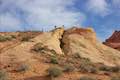 | Rainbow Vista This scenic hike of up to 1.5 miles explores multi-colored landscapes, crossing through sandstone formations to summit a short crest with tremendous 360-degree views and the option to continue to Fire Canyon Overlook. |
 | White Domes This 1.1-mile loop is impressive from start to finish as it explores colorful, intricate rock formations, passes and old film set, and slips through a narrow slot canyon. |
Red Rock Canyon National Conservation Area
 | Calico I and Calico II This hike of 0.8 to 2.75 miles or more explores dramatically shaped and colored sandstone formations in the Calico Hills near the start of Scenic Drive. |
 | Calico Tanks This 2.5-mile hike ventures up a colorful canyon to a pond in a sandstone-framed basin alongside a big view of Las Vegas. |
 | Lost Creek Canyon This short hike visits Lost Creek Waterfall, a seasonal waterfall in a steep canyon above Red Rock Wash. |
 | Red Spring Boardwalk This easy 0.55-mile nature trail circles a meadow at the base of the Calico Hills and visits a small but relied upon spring. |
 | Willow Springs Loop This 1 to 1 1/3-mile circuit travels along Red Rock Wash, exploring desert landscapes, Native American rock art, and potentially a seasonal waterfall. |
hikespeak