Tinker Falls Trail Labrador Hollow Unique Area Waterfall hike Tully New York State Forest
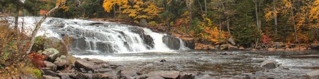
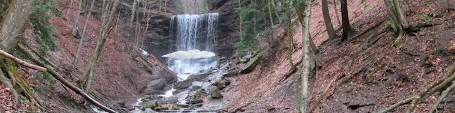
Tinker Falls is a beautiful 50-foot waterfall in Labrador Hollow Unique Area, a New York State Department of Environmental Conservation (NYSDEC) State Forest on the border of Onondaga County and Cortland County in Central New York. The base of the waterfall can be reached via Tinker Falls Trail on an easy half-mile round trip hike with 50 feet of elevation gain. ...Read more.
My Hikes: Completed hikeA green icon of shows a picture of a landscape with a check mark in the upper right corner, signifying that this is a hike you would like to put on your completed list.OK! Add to trails I've hiked
My Hikes: Want to hikeA green icon of shows a picture of a landscape with a heart in the upper right corner, signifying that this is a hike you would like to put on your to-do list.OK! Add to trails I want to hike
TagsA green icon depicting a tags represents a list of words and phrases that this content is tagged with Tagged with · Cortland County · Labrador Hollow Unique Area · New York State Forests · Onondaga County · Tully · Waterfalls
Hike DistanceA green icon of a hiker used to label information about the length of the hike Distance: 0.5 miles · Elevation change: 50 feet
By: Published: Last updated: April 12, 2017
Labrador Hollow Boardwalk New York State Forest hike Labrador Hollow Unique Area
Tranquil Labrador Pond lies at the heart of New York State's Labrador Hollow Unique Area on the border of Onondaga County and Cortland County. Fine views of Labrador Pond can be found on Labrador Hollow Boardwalk, a half-mile long wheelchair-friendly walkway through the wetlands bordering Labrador Pond. The quick walk reaches a viewpoint on the shore of the hill-cradled pond and is a great introduction to the Labrador Hollow Unique Area. ...Read more.
My Hikes: Completed hikeA green icon of shows a picture of a landscape with a check mark in the upper right corner, signifying that this is a hike you would like to put on your completed list.OK! Add to trails I've hiked
My Hikes: Want to hikeA green icon of shows a picture of a landscape with a heart in the upper right corner, signifying that this is a hike you would like to put on your to-do list.OK! Add to trails I want to hike
TagsA green icon depicting a tags represents a list of words and phrases that this content is tagged with Tagged with · Cortland County · Labrador Hollow Unique Area · Lakes · New York State Forests · Onondaga County · Tully · Wheelchair-Friendly
Hike DistanceA green icon of a hiker used to label information about the length of the hike Distance: 0.5 miles · Elevation change: 10 feet
By: Published: Last updated: April 12, 2017
Beaver Lake Nature Center Winter Trails Snowshoeing Onondaga County Park Baldwinsville New York Southern Exposure Snowshoe Trail
When the snow falls in Central New York, it's time to trade in your hiking books for snowshoes and explore a wonderland of winter landscapes. Onondaga County's Beaver Lake Nature Center is a perfect destination for winter fun. The 660-acre park operates trails for snowshoeing and cross-country skiing, and even rents snowshoes for a small fee so that everyone can get in on the fun. ...Read more.
My Hikes: Completed hikeA green icon of shows a picture of a landscape with a check mark in the upper right corner, signifying that this is a hike you would like to put on your completed list.OK! Add to trails I've hiked
My Hikes: Want to hikeA green icon of shows a picture of a landscape with a heart in the upper right corner, signifying that this is a hike you would like to put on your to-do list.OK! Add to trails I want to hike
TagsA green icon depicting a tags represents a list of words and phrases that this content is tagged with Tagged with · Baldwinsville · Beaver Lake Nature Center · Onondaga County · Onondaga County Park · Snowshoeing
Hike DistanceA green icon of a hiker used to label information about the length of the hike Distance: 2.2 miles · Elevation change: 50 feet
By: Published: Last updated: July 24, 2025
Green Lakes State Park New York hike Green Lake Trail Round Lake Loop
Green Lakes State Park was created in 1925 to preserve two aquamarine-colored glacially-carved lakes in Central New York. There are trails circling both of these jewels, Green Lake and Round Lake, which you can combine for a peaceful and easy 3.25-mile hike. The trail is almost entirely level, providing a casual 90-minute walk through the verdant forest that frames the lakes. ...Read more.
My Hikes: Completed hikeA green icon of shows a picture of a landscape with a check mark in the upper right corner, signifying that this is a hike you would like to put on your completed list.OK! Add to trails I've hiked
My Hikes: Want to hikeA green icon of shows a picture of a landscape with a heart in the upper right corner, signifying that this is a hike you would like to put on your to-do list.OK! Add to trails I want to hike
TagsA green icon depicting a tags represents a list of words and phrases that this content is tagged with Tagged with · Fayetteville · Green Lakes State Park · Lakes · New York State Parks · Onondaga County
Hike DistanceA green icon of a hiker used to label information about the length of the hike Distance: 3.25 miles · Elevation change: 25 feet
By: Published: Last updated: April 12, 2017
Blue Mountain Lake Campground Adirondacks camp New York camping
Would you like to camp on an island in an Adirondack Lake? Take a trip to Blue Mountain Lake in Hamilton County. The picturesque 1,220-acre lake has six designated campsites that are free and first-come first-serve, so throw your tent and gear in a boat and check out the primitive camping on Blue Mountain Lake! To sign out a campsite, make your way to the public beach and boat ramp along Route 28 at the southeast corner of Blue Mountain Lake. ...Read more.
TagsA green icon depicting a tags represents a list of words and phrases that this content is tagged with Tagged with · Adirondack Mountains · Adirondack Park · Blue Mountain Lake · Canoe & Kayak · Lakes · Tent Camping
By: Published: Last updated: July 17, 2025
Rock Lake Trail Adirondacks Blue Mountain Lake New York hike
Several Adirondack lakes line the roadways in Hamilton County, New York (Blue Mountain Lake, Indian Lake, Long Lake, and Raquette Lake to name a few), but sometimes it is more refreshing to hike to a scenic lake that can't be seen from the road. Leave the vehicle noise behind on this easy 1.6-mile round trip hike with just 100 feet of elevation change. ...Read more.
My Hikes: Completed hikeA green icon of shows a picture of a landscape with a check mark in the upper right corner, signifying that this is a hike you would like to put on your completed list.OK! Add to trails I've hiked
My Hikes: Want to hikeA green icon of shows a picture of a landscape with a heart in the upper right corner, signifying that this is a hike you would like to put on your to-do list.OK! Add to trails I want to hike
TagsA green icon depicting a tags represents a list of words and phrases that this content is tagged with Tagged with · Adirondack Mountains · Adirondack Park · Backpacking · Free Trails · Lakes
Hike DistanceA green icon of a hiker used to label information about the length of the hike Distance: 1.6 miles · Elevation change: 100 feet
By: Published: Last updated: July 23, 2025
Sawyer Mountain Trail Adirondack Mountains New York hike
For summit views without the usual summit effort, head to Sawyer Mountain in the Adirondacks. The trail to the top of the mountain gains 650 feet over a 2.5-mile round trip hike. While the trail travels through a sheltered hardwood forest the entire way, there are two overlooks around the summit that provide far-reaching views over the trees across the surrounding valleys, ridges, and summits. ...Read more.
My Hikes: Completed hikeA green icon of shows a picture of a landscape with a check mark in the upper right corner, signifying that this is a hike you would like to put on your completed list.OK! Add to trails I've hiked
My Hikes: Want to hikeA green icon of shows a picture of a landscape with a heart in the upper right corner, signifying that this is a hike you would like to put on your to-do list.OK! Add to trails I want to hike
TagsA green icon depicting a tags represents a list of words and phrases that this content is tagged with Tagged with · Adirondack Mountains · Adirondack Park · Free Trails · Summits
Hike DistanceA green icon of a hiker used to label information about the length of the hike Distance: 2.5 miles · Elevation change: 650 feet
By: Published: Last updated: July 23, 2025
Grassy Pond Trail Adirondacks Blue Mountain Lake New York hike
The Adirondack Mountains are dotted with lakes and mountains, so it should come as no surprise that you can hike to one or two peaceful ponds on this trail near Eagle Lake and Blue Mountain Lake. For those looking for something on the shorter side, it is an easy one-mile round trip hike to Grassy Pond. For those looking to immerse themselves in the Adirondacks, hike past Grassy Pond for a six-mile round trip trek to Wilson Pond. ...Read more.
My Hikes: Completed hikeA green icon of shows a picture of a landscape with a check mark in the upper right corner, signifying that this is a hike you would like to put on your completed list.OK! Add to trails I've hiked
My Hikes: Want to hikeA green icon of shows a picture of a landscape with a heart in the upper right corner, signifying that this is a hike you would like to put on your to-do list.OK! Add to trails I want to hike
TagsA green icon depicting a tags represents a list of words and phrases that this content is tagged with Tagged with · Adirondack Mountains · Adirondack Park · Blue Mountain Lake · Free Trails · Lakes
Hike DistanceA green icon of a hiker used to label information about the length of the hike Distance: 1 mile · Elevation change: 75 feet
By: Published: Last updated: April 23, 2017
Buttermilk Falls Trail Adirondacks Long Lake New York Waterfall
Would you like to try some buttermilk? Take the half-mile round trip hike to Buttermilk Falls in New York's Adirondack Mountains. The short, wide waterfall is a beautiful and easy-to-reach destination on the Raquette River near Long Lake. Buttermilk Falls is one of the area's most popular trails, and rightfully so. The short hike to Buttermilk Falls begins from a trailhead on North Point Road west of Long Lake and north of Blue Mountain Lake. ...Read more.
My Hikes: Completed hikeA green icon of shows a picture of a landscape with a check mark in the upper right corner, signifying that this is a hike you would like to put on your completed list.OK! Add to trails I've hiked
My Hikes: Want to hikeA green icon of shows a picture of a landscape with a heart in the upper right corner, signifying that this is a hike you would like to put on your to-do list.OK! Add to trails I want to hike
TagsA green icon depicting a tags represents a list of words and phrases that this content is tagged with Tagged with · Adirondack Mountains · Adirondack Park · Free Trails · Waterfalls
Hike DistanceA green icon of a hiker used to label information about the length of the hike Distance: 0.5 miles · Elevation change: 25 feet
By: Published: Last updated: July 23, 2025
Uncle Tom's Trail Lower Falls Grand Canyon of the Yellowstone River in Yellowstone National Park
If Uncle Tom's Trail can be called a trail, then you can just as easily say you are going for a hike any time you take the stairs instead of the elevator. This Yellowstone National Park trail consists of over 300 steel steps built down the south wall of the Grand Canyon of the Yellowstone River next to the park's most impressive waterfall. The up-close views of Lower Falls are electrifying and this 0. ...Read more.
My Hikes: Completed hikeA green icon of shows a picture of a landscape with a check mark in the upper right corner, signifying that this is a hike you would like to put on your completed list.OK! Add to trails I've hiked
My Hikes: Want to hikeA green icon of shows a picture of a landscape with a heart in the upper right corner, signifying that this is a hike you would like to put on your to-do list.OK! Add to trails I want to hike
TagsA green icon depicting a tags represents a list of words and phrases that this content is tagged with Tagged with · Grand Canyon of the Yellowstone · National Parks · Stairs · Waterfalls
Hike DistanceA green icon of a hiker used to label information about the length of the hike Distance: 0.7 miles · Elevation change: 500 feet
By: Published: Last updated: July 23, 2025