Catherine Creek Interpretive Trail in Columbia River Gorge National Scenic Area
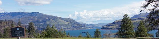
Hikers pack the slopes of Dog Mountain to see spring wildflowers, but tackling a lot of elevation is not required to see one of the best blooms in Columbia River Gorge National Scenic Area. Instead, visit Catherine Creek, where an easy, paved 0.9-mile loop (with just 100 feet of elevation change) floods with wildflowers in the spring and early summer. ...Read more.
Distance: 0.9 miles · Elevation change: 100 feet
By: Published: May 2, 2018 Last updated: April 8, 2026
Saddle Mountain Trail in Saddle Mountain State Natural Area
One hike in Northwest Oregon really rises above the rest. Saddle Mountain is the highest point in the northern half of the Coast Range with sweeping 360-degree from a 3,283-foot summit that look out over the Pacific Ocean, the Columbia River, and inland toward the Cascade Range. The hike up Saddle Mountain Trail is 5 miles round trip with 1,635 feet of elevation change (including steep passages). ...Read more.
Tagged with · Free Trails · Seaside · Summits
Distance: 5 miles · Elevation change: 1635 feet
By: Published: April 10, 2018 Last updated: April 8, 2026
Dogwood Trail – Alder Trail Loop in Forest Park, Portland
Forest Park is a wonderful place to take a short hike in Portland. For a 5-trail, four-season outing, check out Dogwood Trail – Alder Trail Loop, which actually uses Keil Trail, Dogwood Trail, Leif Erikson Drive, Alder Trail, and Wildwood Trail to form a 2.8-mile circuit with just over 400 feet of elevation change. In the summer, these Forest Park trails offer cooling shade. ...Read more.
Distance: 2.8 miles · Elevation change: 410 feet
By: Published: March 23, 2018 Last updated: April 18, 2026
Clear Lake Loop in Willamette National Forest
The pristine Cascadian jewel called Clear Lake, was forged in the fires of a volcanic eruption, 3,000 years ago. The lave flow that dammed the lake still occupies stretches of the shoreline. A loop trail around Clear Lake weaves through resilient old growth forests and fields of volcanic rock, offering beautiful lake views around almost every turn. ...Read more.
Distance: 5 miles · Elevation change: 75 feet
By: Published: December 21, 2017 Last updated: April 18, 2026
Beaver Falls in Clatskanie, Oregon
Just off Route 30 between Portland and Astoria, travelers can gush over a short hike to a lovely waterfall. Beaver Falls (a.k.a. Beaver Creek Falls) takes a single-drop plunge off a basalt ledge. The waterfall is nearly 50 feet tall and swells to 40 feet wide. This quick delight of a hike descends 100 feet through forest for a 0.7-mile round trip outing. ...Read more.
Tagged with · Clatskanie · Free Trails · Waterfalls
Distance: 0.7 miles · Elevation change: 100 feet
By: Published: December 19, 2017 Last updated: December 5, 2025
Round Lake Loop & Pothole Falls in Lacamas Lake Regional Park
Potholes aren't always bad. The creatively carved-out bedrock at Pothole Falls adds to the allure of the cascades. Pothole Falls is just a stone's throw from Round Lake, a 26-acre body in Lacamas Lake Regional Park in Camas, Washington. Round Lake Loop Trail offers a relaxing nature trail through lake-edge forest. Circle Round Lake and check out Pothole Falls on a 1. ...Read more.
Distance: 1.6 miles · Elevation change: 200 feet
By: Published: December 14, 2017 Last updated: April 9, 2026
Dog Mountain in Columbia River Gorge National Scenic Area
It isn't pack mentality that makes Dog Mountain one of the most popular hikes on the Washington side of the Columbia River Gorge. The grassy slopes near the summit put on a winning display of spring wildflowers, enhancing year-round views over the gorge's beautiful surroundings. Dog Mountain Trail is steep and largely forested, ascending 2,825 feet in 3 1/3 miles. ...Read more.
Distance: 7.4 miles · Elevation change: 2825 feet
By: Published: September 2, 2017 Last updated: April 18, 2026
Coyote Wall in Columbia River Gorge National Scenic Area
Take a drive through the Columbia River Gorge and you're sure to be impressed by a diagonal band of cliffs on the Washington side of the gorge that rise from the river toward the mountains above. These grand and daunting cliffs are called Coyote Wall or the Syncline. A network of single-track trails and old jeep roads extend up alongside the columnar basalt ledge. ...Read more.
Distance: 5.8 miles · Elevation change: 1575 feet
By: Published: July 28, 2017 Last updated: April 18, 2026
South Falls in Silver Falls State Park
South Falls is the tallest waterfall in Silver Falls State Park, dropping a spectacular 177 feet off a basalt shelf. South Falls can be visited (along with nine other waterfalls) on the park's great loop, the Trail of Ten Falls. When this 7.9-mile loop is too much, a 1.1-mile lollipop loop can be hiked to visit South Falls on its own. The short hike has 200 feet of elevation change. ...Read more.
Distance: 1.1 miles · Elevation change: 200 feet
By: Published: July 10, 2017 Last updated: April 18, 2026
Camping in Beacon Rock State Park
Tucked into the Washington side of the Columbia River Gorge, Beacon Rock State Park has great places camp and kick back after a day of traveling in the gorge or hiking Hamilton Mountain and Beacon Rock. Main Campground In the forest up the road from Hamilton Mountain Trailhead, you'll find the park's main campground spread around a single loop. A mossy ledge of basalt rises over one side of the campground. ...Read more.
By: Published: July 10, 2017 Last updated: April 10, 2026