Mirror Lake in Yosemite National Park
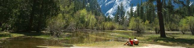
Wedged between the granite walls of Half Dome and North Dome on the east end of Yosemite Valley, visit an enticing body of water that doubles the Yosemite splendor. Mirror Lake, which is not actually a lake but rather a shallow seasonal pool, is famous for its reflective beauty. Due to it's popularity and easy-to-reach-ness, a few trails lead to Mirror Lake. ...Read more.
Tagged with · Creeks · Lakes · National Parks · Yosemite Valley
Distance: 2.8 miles · Elevation change: 100 feet
By: Published: June 7, 2011 Last updated: April 8, 2026
Lower Yosemite Fall Trail in Yosemite National Park
A pair of paved paths lead to a viewing bridge below Lower Yosemite Fall, creating a 1.2-mile loop to the foot of the tallest waterfall in North America, and the fifth tallest in the world. The western side of the loop is laid out in a line with Yosemite Falls to provide absolutely eye-popping, jaw-dropping, imagination-defying, awe-inspiring views of the 2,425-foot waterfall. ...Read more.
Distance: 1.2 miles · Elevation change: 100 feet
By: Published: May 26, 2011 Last updated: April 18, 2026
Taft Point in Yosemite National Park
The panoramic view from Taft Point and the rock fissures nearby provide a rewarding 2-mile hike. The dirt single track descends just 250 feet to an outcropping on the south wall of Yosemite Valley that overlooks El Capitan and Yosemite Falls. Yosemite Fall from Taft Point From the trailhead, turn left and begin a peaceful walk through a big pine forest bordering a high elevation meadow. ...Read more.
Distance: 2 miles · Elevation change: 250 feet
By: Published: May 25, 2011 Last updated: December 5, 2025
Bridalveil Fall in Yosemite National Park
The 620-foot single-drop Bridalveil Fall is not the longest waterfall in Yosemite National Park, but it is one of the most elegant. A half mile round trip hike delivers visitors to a viewing platform at the base the waterfall. The short and easy hike is not to be missed. From the trailhead, Bridalveil Fall is visible through the pine forest, plunging from a hanging valley along the south wall of Yosemite Valley. ...Read more.
Distance: 0.5 miles · Elevation change: 50 feet
By: Published: May 23, 2011 Last updated: December 6, 2025
Mariposa Grove of Giant Sequoias in Yosemite National Park
Is it a competition? Like Sequoia National Park, Yosemite invites visitors to its own groves of giant sequoias, namely the Mariposa Grove near the park's south entrance. Every giant sequoia grove is specoal, but does Yosemite have a tree that compares to Sequoia's General Sherman Tree, the biggest tree in the world? The Grizzly Giant in Mariposa Grove is a massive tree to see. ...Read more.
Tagged with · National Parks · Sequoia Groves
Distance: 1.6 miles · Elevation change: 400 feet
By: Published: May 22, 2011 Last updated: April 13, 2026
Chilnualna Falls Trail in Yosemite National Park
This less-traveled single track on the southern end of Yosemite National Park visits thundering cascades and one of the longest falls in the park outside Yosemite Valley. Chilnualna Falls Trail passes through charming forests on the way to Upper Chilnualna Falls where hikers can connect to other trails delving into the Yosemite backcountry. Chilnualna Falls Trail is rated as strenuous for its length more than its pitch. ...Read more.
Distance: 8 miles · Elevation change: 2200 feet
By: Published: May 20, 2011 Last updated: April 18, 2026
Lemon Grove Loop Trail in San Luis Obispo
This 2.2-mile loop explores a 120-acre open space between Cerro San Luis and downtown San Luis Obispo. With just three hundred feet of elevation gain, this is a quick hike on its own, or an easy extension to the steeper trek up Cerro San Luis. The abandoned lemon grove that gives the trail its name is becoming more of a destination thanks to the planting of new trees. ...Read more.
Tagged with · Free Trails · Morros
Distance: 2.2 miles · Elevation change: 300 feet
By: Published: May 13, 2011 Last updated: December 5, 2025
Cerro San Luis in San Luis Obispo
Located just west of downtown San Luis Obispo, the 1,292-foot Cerro San Luis (or San Luis Mountain) offers sweeping views over the city and surroundings. Cerro San Luis is a member of the Morros, or Nine Sisters, a chain of prominent volcanic peaks stretching east from Morro Bay. These beautiful peaks set the postcard-like backdrop for San Luis Obispo and are excellent places to hike. ...Read more.
Tagged with · Free Trails · Morros · Summits
Distance: 4 miles · Elevation change: 1100 feet
By: Published: May 11, 2011 Last updated: December 5, 2025
Sam Merrill Trail to Echo Mountain in the San Gabriel Mountains
Long ago, back in the 90s - that is the 1890s, the resort built on Echo Mountain was one of the largest tourist draws in California. Thaddeus Lowe's resort, known as the White City, was perched at an elevation of 3,200 feet, overlooking the city of Pasadena and a grand stretch of Southern California. The resort was long ago destroyed by wildfires, leaving fascinating ruins for present day visitors to explore. ...Read more.
Distance: 5.8 miles · Elevation change: 1400 feet
By: Published: May 9, 2011 Last updated: April 19, 2026
Rubio Canyon Trail in the San Gabriel Mountains
This short hike travels up a narrow history-filled canyon to a charming double waterfall.  At the turn of the previous century, the canyon was home to Rubio Pavilion, at the base of the Mount Lowe Incline Tramway, which escorted visitors to an immensely popular resort atop the ridge to the west.  A hundred years later, only the foundation remains and nature has rebounded to provide a rustic hiking alley. ...Read more.
Distance: 1.3 miles · Elevation change: 350 feet
By: Published: May 2, 2011 Last updated: April 9, 2026