Calcite Springs Overlook in Yellowstone National Park
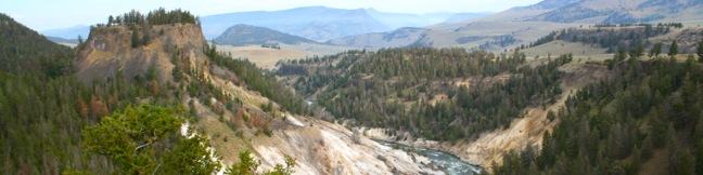
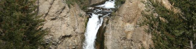
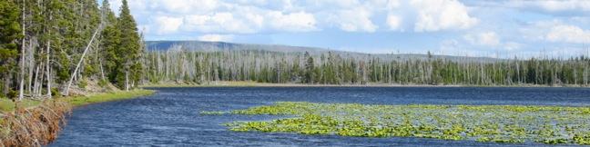
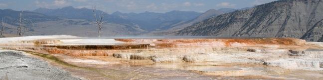
When you drive by an overlook in Yellowstone National Park, it pays to stop. A short walk from a turnout on Grand Loop Road just north of Tower Fall brings travelers to Calcite Springs Overlook, perched on a bluff above the narrowest section of the Grand Canyon of Yellowstone. The mesmerizing northward view puts a rugged section of the Yellowstone River on display, accented by bleached cliffs and steam venting hydrothermal springs. ...Read more.
Distance: 0.25 miles · Elevation change: 25 feet
By: Published: August 19, 2012 Last updated: April 13, 2026
Tower Fall in Yellowstone National Park
Tower Fall drops 132 feet down Tower Creek just before the creek converges with the Yellowstone River. A hellish collection of towering volcanic spires surrounding the creek gives Tower Fall its name. There is an excellent view of Tower Fall from an easy-to-reach roadside overlook. A 1-mile round trip hike drops down to the Yellowstone River alongside Tower Creek and previously connected to a viewing platform at the base of the falls. ...Read more.
Distance: 1 mile · Elevation change: 225 feet
By: Published: August 18, 2012 Last updated: April 9, 2026
West Thumb Geyser Basin in Yellowstone National Park
There are several hydrothermal areas in Yellowstone National Park. West Thumb Geyser Basin stands out because it is on the edge of, and partially submerged by, Yellowstone Lake, which creates a dramatic backdrop for the dynamic geysers, pools, and springs. A dirt trail and wooden boardwalk loops through the geyser basin, offering a 2/3 of a mile long wheelchair-friendly stroll. ...Read more.
Distance: 0.65 miles · Elevation change: 25 feet
By: Published: August 16, 2012 Last updated: April 8, 2026
Monument Geyser Basin in Yellowstone National Park
Monument Geyser Basin is an active hydrothermal area that most visitors to Yellowstone National Park won't get to see. That's because most visitors won't pursue the 2.8-mile round trip hike required to reach the basin. There is 700 feet of elevation gain standing in the way, as the trail climbs a pine-covered mountainside with views of Mount Holmes and a snaking section of the Gibbon River. ...Read more.
Tagged with · Hydrothermal · National Parks
Distance: 2.8 miles · Elevation change: 700 feet
By: Published: August 14, 2012 Last updated: April 9, 2026
Artists’ Paintpots in Yellowstone National Park
Artists' Paintpots Trail is located 3.7 miles south of the Norris Geyser Basin (home of the world's tallest geyser) on the west side of Yellowstone National Park. A 1.1-mile loop circles a hillside hydrothermal area, passing bursting mudpots, bubbling hot springs, and mesmerizing milky blue pools. There is 125 feet of elevation gain along this fun and easy lollipop loop with plenty to see. ...Read more.
Distance: 1.1 miles · Elevation change: 125 feet
By: Published: August 13, 2012 Last updated: April 6, 2026
Riddle Lake Trail in Yellowstone National Park
Riddle Lake Trail delivers an easy day hike across the Continental Divide to one of Yellowstone's backcountry lakes. The 5-mile round trip hike is almost as flat as the lake itself, with 100 hard-to-detect feet of elevation change. Riddle Lake is a beautiful blue body with a small beach. The lake is surrounded by lodgepole pine and mountain views. Even through the trail is easy enough for just about everyone, there is a good chance you will have the lake all to yourself, which is a bonus in this popular national park. ...Read more.
Distance: 5 miles · Elevation change: 100 feet
By: Published: August 11, 2012 Last updated: April 9, 2026
Mammoth Hot Springs in Yellowstone National Park
Yellowstone National Park might have a lot of must see attractions, but you should not leave the park without visiting Mammoth Hot Springs. This impressive hydrothermal area may not have any high-spouting geysers, but it does have one of the world's greatest collections of hot springs with terraces made up of travertine deposits. The colorful steps and pools at Mammoth Hot Springs look more like something you would see in a cave next to stalactites than anything you are used to seeing above ground. ...Read more.
Distance: 1.75 miles · Elevation change: 300 feet
By: Published: August 10, 2012 Last updated: April 7, 2026
Wraith Falls in Yellowstone National Park
Yellowstone has lots of amazing natural features to explore, but sometimes it's the unassuming trail that delivers the most surprising enjoyment. Wraith Falls is not one of Yellowstone's biggest or boldest waterfalls, but the 0.8-mile round trip hike to the 100-foot streaking cascade is as pleasant as it is easy. After making a beeline across a grassy meadow to the creek below Wraith Falls, the trail turns uphill, climbing fifty feet (out of a total of 100 feet of elevation gain) in the last tenth of a mile to a viewpoint of Wraith Falls. ...Read more.
Tagged with · National Parks · Waterfalls
Distance: 0.8 miles · Elevation change: 100 feet
By: Published: August 9, 2012 Last updated: April 8, 2026
Boiling River in Yellowstone National Park
While Boiling River Trail is about as easy and straightforward as they come, the destination is completely unconventionally. The 1.25-mile round trip hike ends at one of America's strangest swimming holes where a stream of water cooked by Yellowstone's hydrothermal features mixes with cold river water. Wear your bathing suit and take a dip in this remarkable hot springs! ...Read more.
Distance: 1.25 miles · Elevation change: 50 feet
By: Published: August 8, 2012 Last updated: April 17, 2026
Fish Canyon Narrows in the Sierra Pelona Mountains
Not to be confused with Fish Canyon Falls on the east end of the Angeles National Forest, the Fish Canyon Narrows reside on the far west end of the Angeles in the Sierra Pelona Mountains north of Santa Clarita. Here a mountain stream passes through hundred-foot cliffs that are at time only twenty feet apart. The red rock walls mimic those you might find hiking in Zion National Park or other Utah canyons. ...Read more.
Distance: 10.5 miles · Elevation change: 650 feet
By: Published: July 22, 2012 Last updated: April 8, 2026