Green Lake Trail and Round Lake Trail Loop in Green Lakes State Park
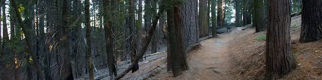
Green Lakes State Park was created in 1925 to preserve two aquamarine-colored glacially-carved lakes in Central New York. There are trails circling both of these jewels, Green Lake and Round Lake, which you can combine for a peaceful and easy 3.25-mile hike. The trail is almost entirely level, providing a casual 90-minute walk through the verdant forest that frames the lakes. ...Read more.
Distance: 3.25 miles · Elevation change: 25 feet
By: Published: July 11, 2013 Last updated: April 10, 2026
San Jacinto Peak via Marion Mountain Trail in the San Jacinto Mountains
San Jacinto Peak is one of the true crowns of Southern California and is a crowning achievement for any hiker who reaches the summit. San Jacinto Peak is the second highest mountain in Southern California and the pinnacle of the San Jacinto Mountain Range at 10,834 feet above sea level. Hikers who spar with San Jacinto Peak should be prepared for an all day challenge. ...Read more.
By: Published: July 8, 2013 Last updated: April 10, 2026
Ernie Maxwell Scenic Trail in the San Jacinto Mountains
The San Jacinto Mountains are a steep rugged mountain range full of challenging trails that put hikers to the test... Ernie Maxwell Scenic Trail is not one of those trails. This leisurely alternative is 5.2 miles round trip with 675 rolling feet of elevation change. The gradual and enjoyable dirt single track overlooks the mountain community of Idyllwild and is appropriate for hikers of all abilities. ...Read more.
Distance: 5.2 miles · Elevation change: 675 feet
By: Published: July 3, 2013 Last updated: April 11, 2026
Indian Mountain in the San Jacinto Mountains
The 6-mile round trip hike to Indian Mountain starts from a convenient trailhead on Route 243, the main road between Banning and Idyllwild. While San Jacinto Peak is the blockbuster summit in the San Jacinto Mountains, this Indy is a crowd pleaser too, requiring a feature-length time commitment of two to three hours to hike to and from the 5,790-foot summit. ...Read more.
Distance: 6 miles · Elevation change: 815 feet
By: Published: July 1, 2013 Last updated: April 9, 2026
Kanawyer Loop Trail in Kings Canyon National Park
Kings Canyon is a rugged trench in the Sierra Nevada Mountains that is so remote it can only be accessed from one road. In such a landscape, where a pristine river slices down a canyon between sheer rock walls, you would not expect to find a long and level trail suitable for casual hikers, but that's exactly what you will find on Kanawyer Loop Trail. ...Read more.
Distance: 5 miles · Elevation change: 125 feet
By: Published: June 27, 2013 Last updated: December 5, 2025
Grant Village to Grant Grove Trail in Kings Canyon National Park
If you visit the Grant Grove Area of Kings Canyon National Park, you will probably want to stop by both the General Grant Tree in the Grant Grove and the visitor center in nearby Grant Village. You can drive between these two locations or connect them on foot with a trail that is one-mile one-way, passing through Azalea Campground to bridge the two busy areas. ...Read more.
Distance: 2 miles · Elevation change: 250 feet
By: Published: June 26, 2013 Last updated: April 9, 2026
North Boundary Trail in Kings Canyon National Park
The General Grant Tree Trail is the busiest hike in the Grant Grove Area of Kings Canyon National Park, but most visitors probably don't know that the popular paved loop can be used to reach North Boundary Trail, a narrow dirt trail that sees little foot traffic. Cross through the Grant Grove to reach a 2.75-mile loop on North Boundary Trail and North Boundary Cutoff Trail that circles a pine forest that borders the famous sequoia grove. ...Read more.
Distance: 3.55 miles · Elevation change: 375 feet
By: Published: June 25, 2013 Last updated: December 5, 2025
General Grant Tree Trail in Kings Canyon National Park
The Grant Grove is one of the top draws in Kings Canyon National Park, containing the park's most important sequoia, the General Grant Tree. The Grant Grove is one of the world's premier sequoia habitats with several of the world's largest trees. It is the oldest section of Kings Canyon National Park, first protected as General Grant National Park in 1890. ...Read more.
Distance: 0.8 miles · Elevation change: 50 feet
By: Published: June 24, 2013 Last updated: December 6, 2025
Dead Giant Loop Trail to Sequoia Lake Overlook in Kings Canyon National Park
Dead Giant Loop Trail is an enjoyable single-track loop trail through a forest of giant sequoias and pines in the Grant Grove Area of Kings Canyon National Park. In addition to a massive still-standing dead sequoia, the lightly traveled trail passes Sequoia Lake Overlook, which presents views over a small blue reservoir to the southwest just outside the national park. ...Read more.
Distance: 2.25 miles · Elevation change: 300 feet
By: Published: June 23, 2013 Last updated: December 6, 2025
North Grove Trail in Kings Canyon National Park
On the west side of the Grant Grove Area of Kings Canyon National Park, you will find the North Grove of Giant Sequoias, where hikers can set out downhill on a loop through a forest of big trees. North Grove Trail is 1.4 miles long and connects to Sunset Trail at both ends to form a 2-mile loop with 350 feet of elevation change. North Grove Trail combines nicely with the adjacent Dead Giant Loop Trail (which passes Sequoia Lake Overlook) for a 3. ...Read more.
Distance: 2 miles · Elevation change: 350 feet
By: Published: June 22, 2013 Last updated: April 10, 2026