Kerosene Creek in Waiotapu
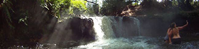
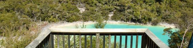
Impressive hydrothermal features surround Rotorua on the North Island of New Zealand. Kerosene Creek is one of the easiest to visit, and it's also free. After a brief walk, hop in a steaming stream and soak in a pool below a short waterfall. They don't call it Kerosene Creek for nothing, but you can forgive the harsh small as you relax in this refreshing hot pool. ...Read more.
Distance: 0.34 kilometers / 0.2 miles · Elevation change: 14 meters / 45 feet
By: Published: May 9, 2015 Last updated: April 16, 2026
Crater Lake in Rainbow Mountain Scenic Reserve
Get ready for a short, colorful walk at Rainbow Mountain Scenic Reserve outside of Rotorua on the North Island of New Zealand. The mountain, which the Māori call Maungakakaramea (mountain of colored earth), has steep red and white cliffs above a crater filled with turquoise water. Crater Lake Walk reaches a lookout above Crater Lake for a 1-kilometer (0. ...Read more.
Distance: 1 kilometer / 0.6 miles · Elevation change: 18 meters / 60 feet
By: Published: May 8, 2015 Last updated: December 5, 2025
Kakepuku Track in Kakepuku Mountain Historic Reserve
Kakepuku Track offers a farm-to-summit trek in Kakepuku Mountain Historic Reserve. The track to the summit of Kakepuku Mountain is 8 kilometers (5 miles) round trip with 407 meters (1,335 feet) of elevation change. A lookout tower atop the 449-meter summit garners round-the-compass views above the treetops. A wooden viewing platform and benches along the track provide spots to relax and look out over the mountain's current surroundings, while panels placed at pa sites around the summit allow visitors to appreciate the Māori past. ...Read more.
Distance: 8 kilometers / 5 miles · Elevation change: 407 meters / 1335 feet
By: Published: April 30, 2015 Last updated: December 5, 2025
Mesa Peak via Mesa Peak Motorway from Corral Canyon Road in the Santa Monica Mountains
It is pretty unusual to hike to a peak from a trailhead at a higher elevation. In the case of Mesa Peak, the lofty trailhead along Corral Canyon Road treats hikers to summit-worthy views right from the get-go. While the elevation profile is atypical, the hike along Mesa Peak Motorway to Mesa Peak in Malibu is quite enjoyable. Ocean overlooks appear all along the wide dirt road, which also passes some very impressive sandstone formations. ...Read more.
Distance: 6.5 miles · Elevation change: 465 feet
By: Published: April 28, 2015 Last updated: December 5, 2025
Whitecliffs Boulders in Rangitikei
Nature produces some surprising creations, like the large, freakishly round boulders found along the Rangitikei River on the North Island of New Zealand. The boulders, known as cannonball concretions, are clustered in a moss-covered forest that is charming to walk through. Take a 4.1-kilometer (2.55-mile) walk across Whitecliffs Farm and up the Rangitikei River to the boulders. ...Read more.
Tagged with · Concretions · Mangaweka · Rangitikei
Distance: 4.1 kilometers / 2.55 miles · Elevation change: 140 meters / 460 feet
By: Published: April 14, 2015 Last updated: December 7, 2025
Summit Valley Edmund D. Edelman Park in the Santa Monica Mountains
Summit Valley Edmund D. Edelman Park preserves 652 acres at the top of Topanga Canyon that were saved from development. Hikers can explore a couple loops through the main area of the park. For a short 1.65-mile hike with 190 feet of elevation change, try Edelman North Loop, which goes along the valley floor before circling back along a wildflower-covered ridge. ...Read more.
Distance: 1.65 miles · Elevation change: 190 feet
By: Published: April 12, 2015 Last updated: April 8, 2026
Calabasas Peak via Calabasas Peak Motorway from Old Topanga Canyon Road in the Santa Monica Mountains
Also known as Calabasas Peak Trail, Calabasas Peak Motorway is a 3.8-mile long dirt fire road that passes below the summit of Calabasas Peak. Hikers on the trail can examine interesting sandstone rock formations on and around Calabasas Peak and enjoy broad views over a scenic part of the Santa Monica Mountains between Topanga and Agoura Hills. One way to reach the summit of Calabasas Peak is to hike from the northeast end of Calabasas Peak Motorway where the fire road meets Old Topanga Canyon Road at the top of the valley west of Topanga. ...Read more.
Distance: 4.2 miles · Elevation change: 635 feet
By: Published: April 9, 2015 Last updated: April 9, 2026
Viewridge Trail and Summer Hill Ranch Road in Summit Valley Edmund D. Edelman Park in the Santa Monica Mountains
Viewridge Trail doesn't look like much at first glance – a one-mile long single track connecting two roads. However, there is a loop beyond the end of Viewridge Trail that reaches an overlook on sandstone outcroppings with panoramic views over Topanga and the middle of the Santa Monica Mountains. This addition elevates Viewridge Trail, and the trail it reaches called Summer Hill Ranch Road, into a very worthy hike in Summit Valley Edmund D. ...Read more.
Distance: 3 miles · Elevation change: 225 feet
By: Published: April 6, 2015 Last updated: December 5, 2025
Kwaay Paay Peak Trail in Mission Trails Regional Park
Pay a visit to Kwaay Paay Peak for an efficient workout that's rewarded with panoramic views. The 2.5-mile round trip hike to the 1,194-foot summit climbs 885 feet, with steep stretches that will have your heart pumping. The summit is just ten miles from downtown San Diego, within the 6,800 acres of Mission Trails Regional Park, so you'll see beautiful natural landscapes and cityscapes on this fun San Diego hike. ...Read more.
Distance: 2.5 miles · Elevation change: 890 feet
By: Published: March 30, 2015 Last updated: December 5, 2025
Old Prospector Trail Loop in Irish Hills Natural Reserve in San Luis Obispo
Today the Irish Hills are like a gold mine for hikers, but the small mountain range in San Luis Obispo historically hosted several mines for chromium and mercury. The ruins of one of these mines can be visited on Old Prospector Trail, which opened in 2015 to join the growing group of trails in Irish Hills Natural Reserve. This hikers-only single track starts in Froom Canyon and is 0. ...Read more.
Tagged with · Free Trails · Irish Hills · Mines · Ruins
Distance: 4.4 miles · Elevation change: 650 feet
By: Published: March 18, 2015 Last updated: April 9, 2026