Artists Palette Death Valley National Park geology tour
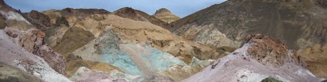
Artist's Drive crosses a sloping mountainside composed of vibrant soil colored by rich metals. The drive passes an area dubbed the Artist's Palette, which is among the unique landmarks in Death Valley National Park that must be seen to believe. Artist's Drive is a one-way road traveling from south to north. For those coming from Badwater Basin, this is an ideal side trek en route to... Read more.
Tagged with · National Parks
By: Published: Last updated: July 2, 2021
Death Valley hike Natural Bridge Canyon Trail
The 2-mile round trip hike up Natural Bridge Canyon is a great trek for those interested in learning about the geological history of Death Valley National Park. Also, the natural bridge is just cool to walk under. A panel at the trailhead provides illustrations of the various geological features visible in the canyon, making it easy for hikers to spot the faults, chutes, and mud drippings... Read more.
OK! Add to trails I’ve hiked
OK! Add to trails I want to hike
Tagged with · Desert Canyons · National Parks · Natural Bridges
Distance: 2 miles · Elevation change: 400 feet
By: Published: Last updated: June 7, 2017
Badwater Basin Death Valley National Park Lowest Point visit Badwater Basin below sea level
Badwater Basin is a must-stop on any first trip to Death Valley National Park. The elevation here is -282 feet, making this the lowest locale in North America. A wooden Sea Level plaque 282 feet over Badwater Basin lets visitors know just how low they've come. Badwater Basin Being able to brag about how far below sea level you've been is not the only reason to stop at Badwater Basin.... Read more.
OK! Add to trails I’ve hiked
OK! Add to trails I want to hike
Tagged with · National Parks
Distance: 1 mile · Elevation change: 10 feet
By: Published: Last updated: December 31, 2017
Death Valley National Park Dante’s View panorama scenic viewpoint overlook
Dante's View is the primary overlook in Death Valley National Park because it offers premier panoramic views. Below Dante's View is Badwater Basin, the lowest point in North America. Across the valley rises Telescope Peak, the highest in the park. Under the morning light, the views are breathtaking in every direction. It feels like cheating to be able to drive right up to such amazing... Read more.
OK! Add to trails I’ve hiked
OK! Add to trails I want to hike
Tagged with · National Parks
Distance: 1 mile · Elevation change: 200 feet
By: Published: Last updated: June 7, 2017
Harmony Borax Trail Death Valley National Park Borax Mining Site Death Valley California Harmony Borax Mining Wagon Attraction
Take a 00.25-mile walk around a Harmony Borax Plant to see a window into the mining past of Death Valley National Park. The Harmony Borax Site is considered to be an outdoor museum because the natural atmosphere in Death Valley preserves artifacts so well. The Harmony Borax plant and wagon cart are left right out in the open for visitors to come see. Along this paved loop, illustrated... Read more.
OK! Add to trails I’ve hiked
OK! Add to trails I want to hike
Tagged with · National Parks · Nature Trails
Distance: 0.25 miles · Elevation change: 25 feet
By: Published: Last updated: June 7, 2017
Salt Creek Trail Death Valley National Park hike Salt Creek Interpretive Trail California
Salt Creek Interpretive Trail is a level, 1-mile long boardwalk loop along what would be considered a pitiful creek anywhere outside of Death Valley National Park. Here it is extraordinary! The salinated stream is home to the Salt Creek Pupfish, a unique and bizarre creature that can survive in these harsh conditions. The small fish is most visible in these waters in the spring. Salt... Read more.
OK! Add to trails I’ve hiked
OK! Add to trails I want to hike
Tagged with · Creeks · National Parks
Distance: 1 mile · Elevation change: 25 feet
By: Published: Last updated: June 7, 2017
Grotto Canyon Hike Death Valley National Park California Hiking Trail
More than a hike, Grotto Canyon in an adventure. The unmarked road leading up the canyon does not show up on park maps, and the canyon itself has an undeveloped feeling of discovery. Rock obstacles in narrow sections of the canyon require some technical climbing, so this is not a stroll for beginners (nearby Mosaic Canyon is more appropriate for those hikers). Grotto Canyon The gravel... Read more.
OK! Add to trails I’ve hiked
OK! Add to trails I want to hike
Tagged with · Desert Canyons · National Parks · Off Trail
Distance: 2 miles · Elevation change: 625 feet
By: Published: Last updated: June 7, 2017
Death Valley Sand Dunes
The most visible (but not the largest) sand dunes in Death Valley National Park are the Mesquite Flat Dunes. A small parking lot located off Highway 190, two miles south of Stove Pipe Wells offers a great starting point for a trek out to the dunes. There is no formal trail to follow, just strike out for the high sands, which are reachable within a half mile. Cross the ridges and aim for... Read more.
OK! Add to trails I’ve hiked
OK! Add to trails I want to hike
Tagged with · National Parks · Off Trail · Sand Dunes
Distance: 3 miles · Elevation change: 100 feet
By: Published: Last updated: February 5, 2024
Mosaic Canyon Trail Death Valley National Park hike California
Walled with both mosaic conglomerates and smooth marbleized rocks, Mosaic Canyon is a fine specimen the geology of Death Valley National Park. Marble Canyon Trail travels up the canyon bottom past all the interesting features for an outing of 1 to 4 miles round trip. Mosaic Canyon From the parking lot at the mouth of the canyon, it is just a short walk into Lower Mosaic Canyon. Hike up... Read more.
OK! Add to trails I’ve hiked
OK! Add to trails I want to hike
Tagged with · Desert Canyons · National Parks
Distance: 4 miles · Elevation change: 750 feet
By: Published: Last updated: June 7, 2017
Ubehebe Crater Death Valley National Park Crater hike California desert
Ubehebe Crater is located in the north end of Death Valley National Park near the Eureka Dunes and Scotty's Castle. A parking lot along the rim provides a great view of the crater, and three trails offer even more. The Science Ubehebe Crater is a maars volcano that was created by a phreatic eruption two to seven thousand years ago. Hot magma converted groundwater into steam, which created... Read more.
OK! Add to trails I’ve hiked
OK! Add to trails I want to hike
Tagged with · Craters · National Parks
Distance: 2 miles · Elevation change: 275 feet
By: Published: Last updated: June 7, 2017