Glacier Point view Yosemite National Park
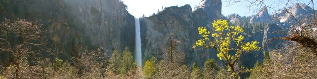
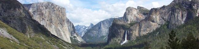
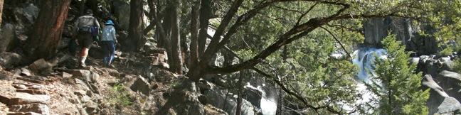
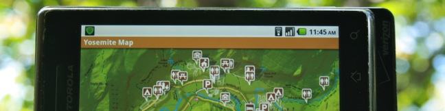
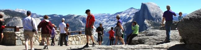
Glacier Point is in incredible overlook in Yosemite National Park. The road to Glacier Point closes in the winter and spring because of snow, but maybe the road should be closed year round. Hear me out... The views from Glacier Point are too extraordinary to be able to drive right up to them! It shouldn't be that easy. Imagine how someone would feel after hiking all the way to the top... Read more.
Tagged with · National Parks · Yosemite Valley
By: Published: Last updated: April 19, 2018
Bridalveil Fall
The 620-foot single-drop Bridalveil Fall is not the longest waterfall in Yosemite National Park, but it is one of the most elegant. A half mile round trip hike delivers visitors to a viewing platform at the base the waterfall. The short and easy hike is not to be missed. From the trailhead, Bridalveil Fall is visible through the pine forest, plunging from a hanging valley along the south... Read more.
By: Published: Last updated: January 30, 2018
Mariposa Grove of Giant Sequoias Yosemite National Park Wawona area day hike
Is it a competition? Like Sequoia National Park, Yosemite invites visitors to its own groves of giant sequoias, namely the Mariposa Grove near the park's south entrance. Every giant sequoia grove is specoal, but does Yosemite have a tree that compares to Sequoia's General Sherman Tree, the biggest tree in the world? The Grizzly Giant in Mariposa Grove is a massive tree to see. Trying to... Read more.
By: Published: Last updated: August 31, 2019
Tunnel View Yosemite National Park El Capitan Tunnel View Yosemite Valley Overlook
On the drive north to Yosemite Valley on Highway 41, as anticipation builds for the beauty ahead, you will pass through a dark tunnel. Suddenly the tunnel end, and an epic view appears, a breathtaking valley with magical waterfalls spilling off dramatic granite wall. Pull over the car and take in the full magnificence of Tunnel View. The eastward vantage into spectacular Yosemite Valley... Read more.
Tagged with · National Parks · Yosemite Valley
By: Published: Last updated: February 5, 2018
Chilnualna Falls Trail Yosemite National Park Wawona area day hike cascade waterfall hiking
This less-traveled single track on the southern end of Yosemite National Park visits thundering cascades and one of the longest falls in the park outside Yosemite Valley. Chilnualna Falls Trail passes through charming forests on the way to Upper Chilnualna Falls where hikers can connect to other trails delving into the Yosemite backcountry. Chilnualna Falls Trail is rated as strenuous for... Read more.
By: Published: Last updated: January 29, 2018
Yosemite National Park Campgrounds camping information Camp Yosemite California
Yosemite National Park is one of the premier areas for outdoor recreation in America and a great place to camp. While you can choose from over 1,600 sites (once all the snow clears), park campgrounds often fill completely. Planning ahead is essential. Many campgrounds in Yosemite National Park take reservations, and in peak summer months, these sites are typically booked far in advance. In... Read more.
By: Published: Last updated: May 13, 2025
Chimani App review Yosemite National Park android iPhone
As dependent as we have become on smartphones, California still has some corners, like Yosemite Valley, where data coverage does not reach. This is a probably a good thing, but it is still handy to have fast information at your fingertips while visiting Yosemite National Park. At its core, Chimani's Yosemite National Park app is a park guide enhanced with a GPS locator. The app is packed... Read more.
Tagged with · App Review · National Parks
By: Published: Last updated: February 26, 2024
Angeles National Forest reopens
For the last year and a half, an immense area of the San Gabriel Mountains has been off limits. Now it's back! Incredible news from the US Forest Service who announced: Effective May 16, [2011] the Angeles National Forest will reopen about half of the areas that have been closed due to the Station Fire. Hikers have battled stunning crowds in pockets of the forest that remained open,... Read more.
By: Published: Last updated: December 9, 2016
Lemon Grove Loop Trail San Luis Obispo hike Cerro San Luis Madonna Mountain Lemon Grove Loop Trail Hike
This 2.2-mile loop explores a 120-acre open space between Cerro San Luis and downtown San Luis Obispo. With just three hundred feet of elevation gain, this is a quick hike on its own, or an easy extension to the steeper trek up Cerro San Luis. The abandoned lemon grove that gives the trail its name is becoming more of a destination thanks to the planting of new trees. The open skies and... Read more.
By: Published: Last updated: May 13, 2025
Cerro San Luis Mountain Summit trail San Luis Obispo Hike Madonna Mountain
Located just west of downtown San Luis Obispo, the 1,292-foot Cerro San Luis (or San Luis Mountain) offers sweeping views over the city and surroundings. Cerro San Luis is a member of the Morros, or Nine Sisters, a chain of prominent volcanic peaks stretching east from Morro Bay. These beautiful peaks set the postcard-like backdrop for San Luis Obispo and are excellent places to hike. ... Read more.
By: Published: Last updated: May 13, 2025