Hikes in Tuolumne County

Tuolumne County is a sparsely populated county in the western sierra. The 2,275-square mile section of California’s Sierra Nevada Mountain Range encompasses the county seat of Sonora and several charming mountain towns. Seventy percent of the county is federally owned, including areas of Stanislaus National Forest and Yosemite National Park.

Hiking Tuolumne County

Dragoon Gulch Trail
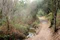
Dragoon Gulch Trail
This 2.5-mile loop ascends 325 feet along a creek and up a ridge to views over Sonora.
Hetch Hetchy
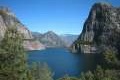
Hetch Hetchy Reservoir and Wapama Falls
This 5-mile hike tours a flooded valley to a thundering waterfall in the northwest corner of Yosemite National Park.
hikespeak
Fallen Leaf Campground South Lake Tahoe Camping Fallen Leaf Lake USDA Forest Service Lake Tahoe Basin Management Unit
While Lake Tahoe's deep blue waters are the region's biggest draw for summertime visitors, the under-the-radar Fallen Leaf Lake is a jewel in its own right. Fallen Leaf Campground is a great basecamp for exploring both lakes, thanks to its central location about 1/4 mile from the north end of Fallen Leaf Lake and a mile from the south end of Lake Tahoe. ...Read more.
TagsA green icon depicting a tags represents a list of words and phrases that this content is tagged with Tagged with · Lake Tahoe Basin National Forest Lands · Lakes · South Lake Tahoe · Tent Camping · Yurts
By: Published: September 11, 2024 Last updated: May 13, 2025
Fallen Leaf Lake Moraine Trail Lake Tahoe Basin South Lake Tahoe Hike
What's better than hiking by a lovely creek - maybe hiking by a lovely lake. You can do both on Moraine Trail, visiting Fallen Leaf Lake and Taylor Creek in the Lake Tahoe Basin National Forest Lands near South Lake Tahoe. This easy and level loop is 1.1 miles long, including a short side trail to Fallen Leaf Lake Dam. The mountain-cradled Fallen Leaf Lake is located just south of Lake Tahoe. ...Read more.
My Hikes: Completed hikeA green icon of shows a picture of a landscape with a check mark in the upper right corner, signifying that this is a hike you would like to put on your completed list.OK! Add to trails I've hiked
My Hikes: Want to hikeA green icon of shows a picture of a landscape with a heart in the upper right corner, signifying that this is a hike you would like to put on your to-do list.OK! Add to trails I want to hike
TagsA green icon depicting a tags represents a list of words and phrases that this content is tagged with Tagged with · Free Trails · Lake Tahoe Basin National Forest Lands · Lakes · South Lake Tahoe
Hike DistanceA green icon of a hiker used to label information about the length of the hike Distance: 1.1 miles · Elevation change: 35 feet
By: Published: July 26, 2023 Last updated: June 22, 2025
Way of the Mono Trail Sierra National Forest Bass Lake View Hike Oakhurst California
Interpretive trails are usually good places to appreciate the finer features of a forest, but they tend to lack grand vistas. This is not the case with Way of the Mono Trail, which rises to a splendid view over Bass Lake, a beauty in the Sierra Nevada Mountains south of Yosemite National Park. Way of the Mono Trail is a 0.6-mile loop with 140 feet of elevation change. ...Read more.
My Hikes: Completed hikeA green icon of shows a picture of a landscape with a check mark in the upper right corner, signifying that this is a hike you would like to put on your completed list.OK! Add to trails I've hiked
My Hikes: Want to hikeA green icon of shows a picture of a landscape with a heart in the upper right corner, signifying that this is a hike you would like to put on your to-do list.OK! Add to trails I want to hike
TagsA green icon depicting a tags represents a list of words and phrases that this content is tagged with Tagged with · Bass Lake · Free Trails · Lakes · Morteros · Native American Heritage · Nature Trails · Oakhurst
Hike DistanceA green icon of a hiker used to label information about the length of the hike Distance: 0.6 miles · Elevation change: 140 feet
By: Published: June 30, 2021 Last updated: June 30, 2021
Chimney Beach Trail Lake Tahoe Nevada Chimney Beach Hike Humboldt-Toiyabe National Forest
Before your visit to Lake Tahoe goes up in smoke, take a hike to Chimney Beach - where a standing-on-its-own fireplace and chimney serve as an unsual landmark for a lovely little cove. The brick chimney is all that's left of an old cabin built in the sand between boulder-strewn points on the east shore of Lake Tahoe. If curiosity about the chimney draws you to Chimney Beach, the beautiful lake views and clear turquoise water will be what keeps you hanging around. ...Read more.
My Hikes: Completed hikeA green icon of shows a picture of a landscape with a check mark in the upper right corner, signifying that this is a hike you would like to put on your completed list.OK! Add to trails I've hiked
My Hikes: Want to hikeA green icon of shows a picture of a landscape with a heart in the upper right corner, signifying that this is a hike you would like to put on your to-do list.OK! Add to trails I want to hike
TagsA green icon depicting a tags represents a list of words and phrases that this content is tagged with Tagged with · Beaches · Carson City · Free Trails · Ruins · South Lake Tahoe
Hike DistanceA green icon of a hiker used to label information about the length of the hike Distance: 1.1 miles · Elevation change: 215 feet
By: Published: July 30, 2019 Last updated: September 11, 2024
Cave Rock Trail Lake Tahoe Nevada Overlook Hike
Gaze out from Route 50 as it travels along the southeast side of Lake Tahoe and you'll find nice views of the lakeshore and its surrounding mountains. Seven miles up from the state border in South Lake Tahoe, Nevada Route 50 slips through a tunnel in a tall pointed ridge of volcanic rock. The road itself is scenic, but the sight of Cave Rock should have you speculating how superb things must look from the top. ...Read more.
My Hikes: Completed hikeA green icon of shows a picture of a landscape with a check mark in the upper right corner, signifying that this is a hike you would like to put on your completed list.OK! Add to trails I've hiked
My Hikes: Want to hikeA green icon of shows a picture of a landscape with a heart in the upper right corner, signifying that this is a hike you would like to put on your to-do list.OK! Add to trails I want to hike
TagsA green icon depicting a tags represents a list of words and phrases that this content is tagged with Tagged with · Free Trails · Glenbrook · South Lake Tahoe · Summits
Hike DistanceA green icon of a hiker used to label information about the length of the hike Distance: 0.9 miles · Elevation change: 165 feet
By: Published: July 25, 2019 Last updated: September 11, 2024