Next to Will Rogers State Historic Park is a shady canyon with a shady past. The ruins of Murphy Ranch, a compound built by Nazi sympathizers in the 1930s have been left behind to decay in Rustic Canyon. For adventuresome hikers, a trail enters Rustic Canyon from the east side of Will Rogers SHP. Beyond the end of the trail is a long unmaintained path up an overgrown canyon to the ruins. Murphy Ranch can be visited as a 4-mile out and back hike with 225 feet of elevation gain, or as a 5-mile loop with 950 feet of elevation gain that circles back to Will Rogers State Historic Park on the Backbone Trail. An alternate route, and the easiest way to the ruins, is to hike to Murphy Ranch from Sullivan Ridge Fire Road on the east side of Rustic Canyon.
The history of Murphy Ranch
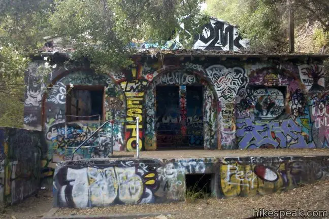
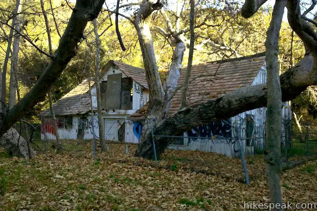
Nazi sympathizers Herr Schmidt, Winona and Norman Stephens, and their followers built this self-contained stronghold in the Pacific Palisades in the 1930s. They planted gardens up the walls of the canyon and constructed several facilities like a power building with a massive diesel generator capable of providing all their electricity. Murphy Ranch was designed to serve as a holdout for fans of the Third Reich waiting for America to fall to the Nazis. Instead, the ranch was raided by U.S. authorities and closed in 1941. The abandoned buildings were transformed into an artists’ colony in the 60s and 70s, before being abandoned after the Mandeville Canyon Fire in 1978. Today the grounds of Murphy Ranch are uninhabited, dilapidated, and covered in graffiti.
Before its demise, Murphy Ranch was said to attract dozens of local Nazi sympathizers who performed military drills during weekend gatherings. Winona and Norman Stephens invested $4 million in Murphy Ranch. They had become convinced that when Europe inevitably fell to Germany, America would be reduced to anarchy, and the National Socialist Party would need a self-sustaining stronghold in the mountains outside Los Angeles to survive the fall and plot the American takeover.
History proved to be a bit different. Authorities monitoring the ranch raided the facility shortly after the bombs fell on Pearl Harbor, arresting Schmidt and others for espionage. A radio capable of communicating with Germany may have been confiscated as well, but many of the specifics of this blight on Los Angeles history have been lost to time.
The Stephens had commissioned famed African-American architect Paul Williams (who designed the homestead now in ruins in Solstice Canyon) to build a four-story mansion within the canyon, but those plans were never executed. Elements of the bizarre retreat that were built have been left to decay by the Los Angeles Department of Parks and Recreation, and are open to the public to explore.
The hike to Murphy Ranch
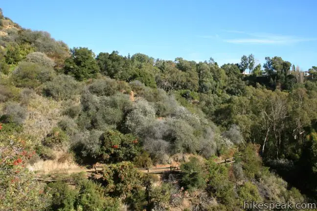
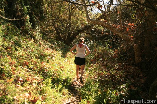
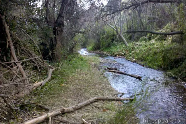
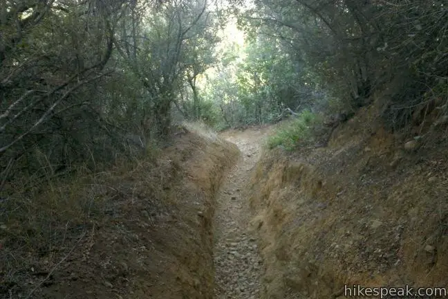
According to rangers at Will Rogers State Historic Park, the trail through Rustic Canyon is unmaintained “because it’s unmaintainable.” Indeed this is not your usual canyon trail with muddy stretches, steep stretches, and hard to follow stretches. The path crisscrosses a creek up a canyon that is very narrow in places. The flow of the creek fluctuates and can deliver its fair share of wet feet. By starting at the bottom of the canyon and hiking up, you reduce the chance of becoming overwhelmed by the water level or getting lost in the canyon. Be prepared for a slow-going adventure and remember that your safety is your responsibility.
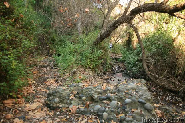
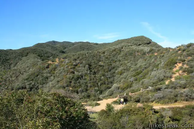
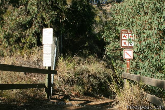
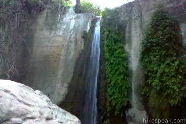
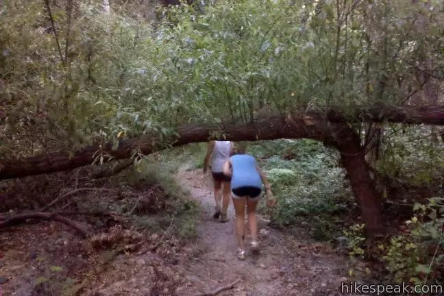
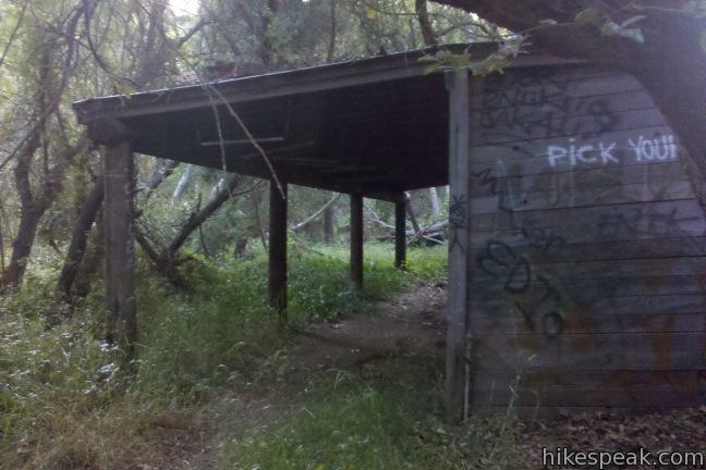
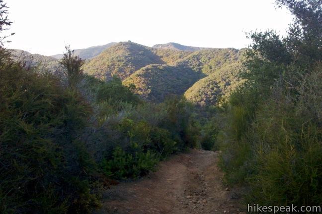
Find Rustic Canyon Trail entering Topanga State Park from the east side of the Will Rogers Polo Field. Hike a third of a mile down a maintained dirt single track dropping into the canyon. When you hit the creek turn left and head up the canyon. The nice trail disappears, leaving you to pick your way up the canyon. A footpath flip-flops across the creek up the narrow canyon through a jungle of vegetation. This is a wild canyon without much of a conduit for hikers. After half a mile you will reach a check dam built across the creek where an artificial waterfall flows. Take the steep track up the dirt slope to the right and continue upstream. It is another mile of bush washing and creek crossing to reach the ruins of Murphy Ranch. When you get close the main ruins, the trail crosses a wooden stable being overgrown by the forest. Stay on the right side of the creek and continue up a faint single track that breaks out of the trees onto a dirt road.
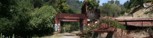
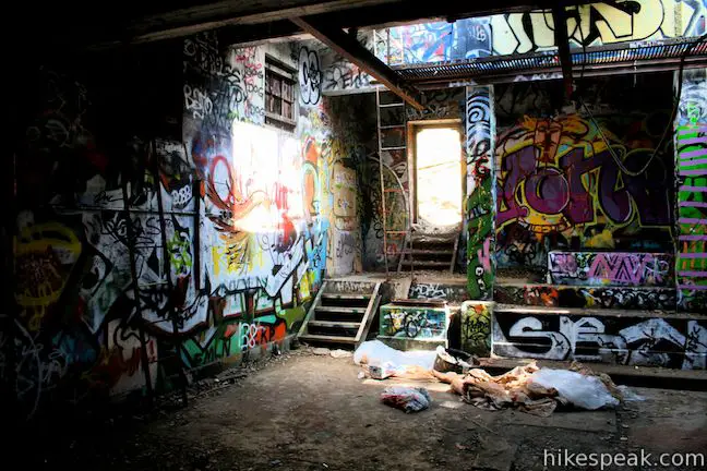
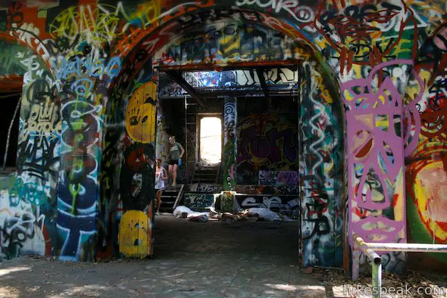
Eureka! Turn left and walk less than a quarter mile to the crumbling ruins of Murphy Ranch, cloaked by live oaks and sycamores. The first building you reach is covered in spray paint and once held the diesel generator and fuel tank that powered the ranch. Step inside the large concrete power building, which has been hollowed of its machinery for a haunting experience.
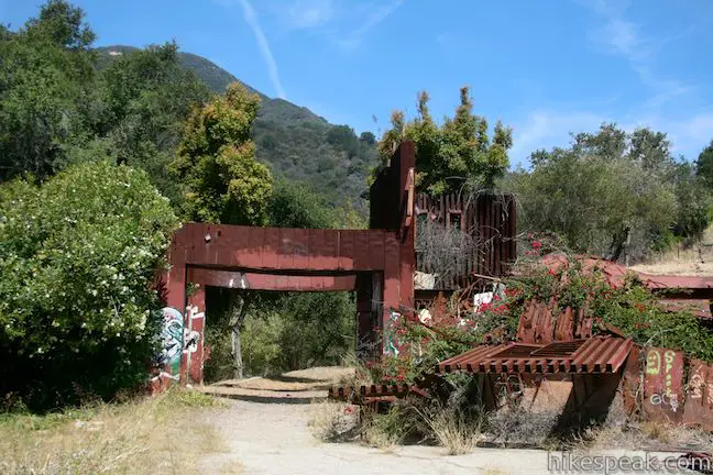
Around the power building are raised gardens and other foundations. The ruins include long cement staircases that climb all the way up the east side of the canyon to Sullivan Ridge Fire Road. These steps offer another way to visit the ruins, a 3.85-mile hike with 325 feet of elevation gain that does not require you to traipse through an arduous unmaintained canyon.
A few hundred feet north of the power building, the road passes a collapsed structure that served as the troop’s machine shed and garage. This is the last major building from the ranch, and the turnaround point for the out and back hike up Rustic Canyon.
To continue the loop, find a path heading farther up the canyon on the right side of the creek above the machine shed. The trail leads you past a large white spooky barn to a junction on the left, a third of a mile above the ruins. Straight ahead the trail continues toward Camp Josepho, a boy scout camp that is closed to hikers. Turn left, following the sign for the Backbone Trail.
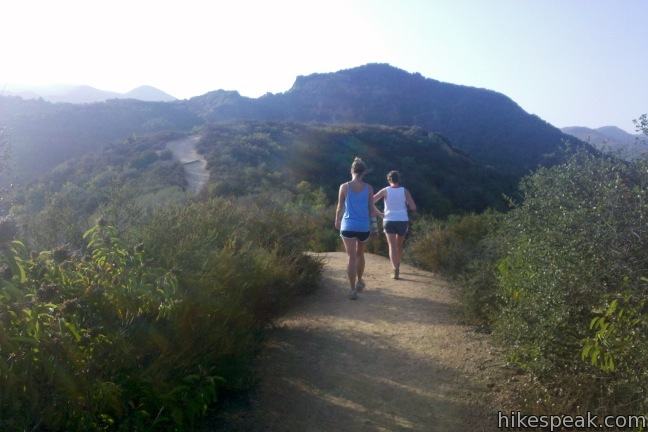
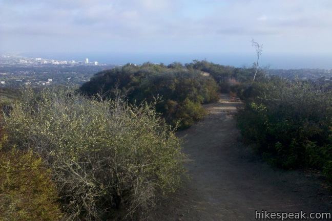
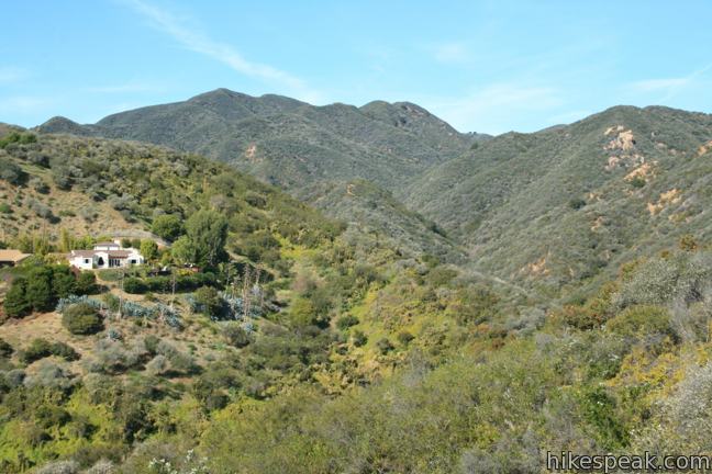
Cross the creek and begin up an ivy-covered forest on the west side of the canyon. The trail climbs a slope of chaparral, tackling 625 feet of elevation in 3/4 of a mile. The trail is steep and rutted toward the top. If the path through the bottom of Rustic Canyon was not so difficult to follow heading downhill, it would be advisable to hike the loop in reverse in order to go down this steep section instead of up. Pause to admire the view over Rustic Canyon as you soldier to the top.
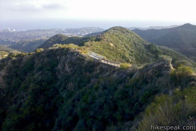
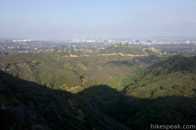
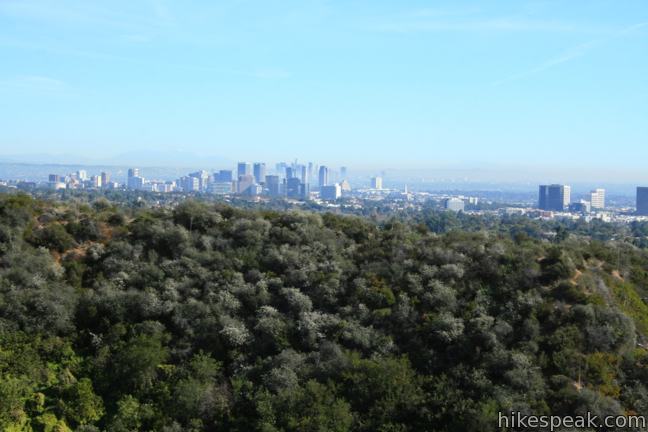
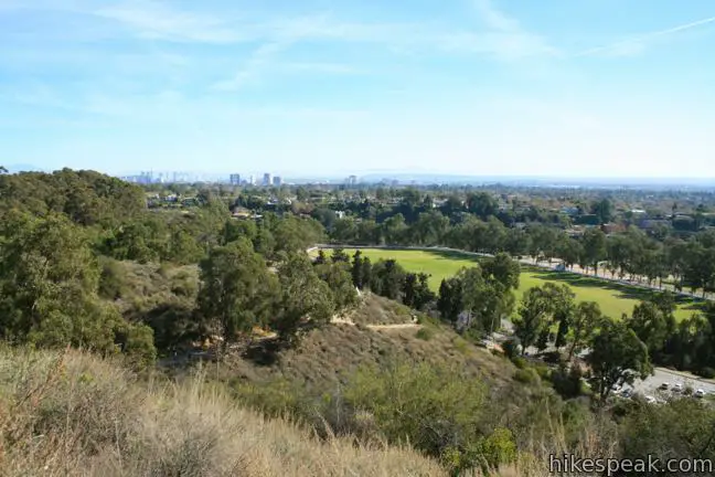
Turn left on the Backbone Trail and hike a short distance south to a panoramic summit to reap the rewards of your effort. The view looks southwest toward Santa Monica Bay and east across the city toward downtown Los Angeles. Continue down the Backbone Trail, crossing a white wooden bridge that straddles a saddle just below the summit. Hike another 0.9 miles down the Backbone Trail to reenter Will Rogers State Historic Park at a junction with Inspiration Point Loop Trail.
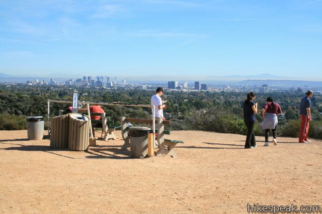
Continue straight (don’t turn left at the junction next to the large park map) to come to a split with the spur trail to Inspiration Point. If you haven’t been inspired yet, turn left and hike another tenth of a mile up to this easy overlook. A grand cityscape is to the southeast in front of downtown Los Angeles. To the southwest, the ocean curls around Santa Monica Bay, and to the north, the Santa Monica Mountains are capped by the 2,126-foot Temescal Peak.
Return to the junction and continue hiking southwest. After a third of a mile, you will come to a junction with a single track on the left. This shortcut heads south and reconnects with the trail below, trimming about 0.2 miles off the distance. Inspiration Point Loop Trail continues to the southwest for a bigger view of the Pacific. The trail bends left and descends east toward the polo fields and the ranch. Follow this trail all the way down to a large lawn east of Will Rogers House. Turn right down the grass to return to the parking area where you started. The lawn is an excellent place to have a picnic or play a game of catch if you still have energy.
Dogs and bikes are not permitted on this hike. The entrance fee for Will Rogers State Historic Park is $12 (as of 2017), but no permit is required to hike to Rustic Canyon, so get out and enjoy.
Update: LA’s Department of Recreation and Parks demolished some of the ruins of Murphy Ranch in the spring of 2016. To visit other area ruins around LA, check out Solstice Canyon, Old Zoo Picnic Area, and Echo Mountain.
Directions to the Trailhead
- Take Sunset Boulevard to Will Rogers State Park Road, located 4.5 miles west of the 405 and three miles east of PCH.
- At the light, turn north on Will Rogers State Park Road.
- Drive 3/4 of a mile up the mountainside to the park entrance.
- Go through the gate and drive straight past the Will Rogers House to the end of the lot above the polo field.
- Park and walk to the east side of the field to find the trail.
Trailhead Location
Trailhead address: 1501 Will Rogers State Park Road, Pacific Palisades, CA 90272
Trailhead coordinates: 34.0546, -118.5109 (34° 03′ 16.56″N 118° 30′ 39.24″W)
(The loop from Will Rogers State Park to Murphy Ranch is in dark blue)
View Santa Monica Mountains in a larger map
Or view a regional map of surrounding Los Angeles trails and campgrounds.


 | Murphy Ranch from Sullivan Ridge This 3.85-mile loop descending from Sullivan Ridge Fire Road into Rustic Canyon, east of Will Rogers State Park, where hikers can visit abandoned buildings once occupied by Nazi sympathizers. |
 | Sullivan Ridge A prominent lone-standing Live Oak along Sullivan Ridge makes a natural turnaround point and a 7.5 to 8.3 mile round trip hike. |
 | Inspiration Point This easy 2.25-mile loop in Will Rogers State Historic Park leads to an overlook with views from Santa Monica Bay to downtown LA. |
 | Rivas Canyon This 2.1-mile (one way) trail crosses a lush secluded canyon connecting Temescal Gateway Park to Will Rogers State Park. |
 | More trails in the Santa Monica Mountains Explore other destinations in the range. |
- Rustic Canyon Loop in Afoot & Afield Los Angeles County by Jerry Schad (opens in a new tab)
- A brochure for Will Rogers State Historic Park including a map of the trails. (opens in a new tab)
- A Los Angeles Times article on the ruins in Rustic Canyon (opens in a new tab)
- A second LA Times article on the ruins in Rustic Canyon (opens in a new tab)
- The official website for Topanga State Park (opens in a new tab)
- The official website for Will Rogers State Historic Park (opens in a new tab)
Common Questions about Rustic Canyon’s Murphy Ranch from Will Rogers State Historic Park
- Is the trail open?
- Yes. You should expect to find that Will Rogers State Park to Murphy Ranch is open. There are no recent reports of trail closures. If you discover that the trail is closed, please help your fellow hikers by reporting a closure.
- Do I need a permit for this hike?
- Yes. State Park Entrance Fee.
- How much time does this hike take?
- It takes approximately 1 hour 45 minutes to hike Will Rogers State Park to Murphy Ranch. Individual hiking times vary. Add extra time for breaks and taking in the views.
- How long is this hike?
- The hike to Will Rogers State Park to Murphy Ranch is 4 miles (out and back) or 5 miles (loop) with 225 feet of elevation change.
- Are dogs allowed on this trail?
- No, dogs are likely not allowed on Will Rogers State Park to Murphy Ranch. The trail is primarily open to hikers.
- Are there ruins on this trail?
- Yes, you can encounter ruins on Will Rogers State Park to Murphy Ranch.
- What mountain range is this trail in?
- Will Rogers State Park to Murphy Ranch is located in the Santa Monica Mountains.
- Where is the trailhead located?
- The trailhead for Will Rogers State Park to Murphy Ranch is located in Pacific Palisades, CA.
Trailhead Address:
1501 Will Rogers State Park Road
Pacific Palisades, CA 90272
Trailhead Coordinates:
34.0546, -118.5109 - What are the driving directions to the start of the hike?
To get to the trailhead: Take Sunset Boulevard to Will Rogers State Park Road, located 4.5 miles west of the 405 and three miles east of PCH. At the light, turn north on Will Rogers State Park Road. Drive 3/4 of a mile up the mountainside to the park entrance. Go through the gate and drive straight past the Will Rogers House to the end of the lot above the polo field. Park and walk to the east side of the field to find the trail.
View custom Google Maps directions from your current location.
- Are there other trails near Will Rogers State Park to Murphy Ranch?
- Yes, you can find other nearby hikes using the Hikespeak Hike Finder Map.

18 Comments on Rustic Canyon’s Murphy Ranch from Will Rogers State Historic Park
What hikers are saying:
✨ Generated summary of user commentsHikers describe this route as a mysterious yet treacherous obstacle course filled with decaying infrastructure and overgrown vegetation. The path frequently disappears into the creek bed, requiring visitors to scramble over downed trees and navigate through thick patches of poison oak. Stanton warns to watch for rattlesnakes near the long staircases, while the presence of heavy tick activity makes wearing long pants tucked into socks essential. Because the trail is not maintained, explorers should prepare for wet feet and significant navigation challenges.
Thanks for the history lesson! I never knew the history of those abandoned buildings until now. Cool, but very creepy.
I’ve done a bit of trail running in CA, WA, ID, and UT, and this has been my favorite one, precisely because it’s so mysterious. I ran it quite a few times when I was in school in L.A. 10 years ago, but never had the chance to do it again until just a couple of days ago (drove up from Dana Point just for it). I’d recommend doing the loop in reverse to what’s described above–it’s true that the trail going down Rustic Canyon is harder to follow than going up, but as long as you stick close to the creek bed, you won’t stray too far. I inevitably get my feet wet, and I’d rather that happen at the end of the run than at the start.
I took this “trail” just the other day with a friend… Unmaintained is an understatement. This path is NOT for the faint of heart.
We followed the path in reverse of what they talk about here. We started up the Backbone Trail, cut across then headed down the Rustic Creek Tail and back Will Rogers. The first two parts were ok. The Backbone Trail is well maintained, and easy to navigate. The cut across down into the canyon was not too bad to follow, however, portions of the trail were very steep. In one or two places loose gravel on the trail also make things rather slick, and you had to be careful not to lose your footing and slide down.
From there things just got worse. The Rustic Trail is not very well marked, when it is marked at all. There are stretches where the trail just disappears completely, and you have to find your way along narrow stretches of the creek bank. Jumping from one side to the other countless times.
There is a ton ducking and climbing. There are downed trees covering the trail at numerous points; some you can easily get over but not most. Being a bit tall myself (6’3″), I had to get down and crawl at a few points to navigate through some of the over growth.
Many times we had to stop and look ahead to try to figure out the best path down the creek. Or even just to see if we could find the path again. A few times we had to back track when we took what we thought was the right path only to find it dead end, or start to head off in the wrong direction.
I cannot even begin to guess how many times we crossed the creek, back and forth as we went along. It was all but impossible to stay dry as we progressed.
Overall this is a very challenging hike and not one I would recommend to just anybody. On the map the loop is a little over 4 miles, it took us just over 3 and a half hours to complete.
We just did this hike today and found this description of the trail, with some historical perspective. While somewhat challenging, the trail wasn’t that difficult, partially, because the water level was quite low. With a bunch of kids starting at 8 years old we took 3 hours to go around, taking plenty of stops along the way. I would recommend going in reverse direction to the description above, otherwise the description is spot on. The hike is different from most in the Santa Monica mountains and I recommend it to all with even a bit of adventurism.
My wife and I did this hike this last weekend and we would agree with Alec’s assessment. To call this a “unmaintained” trail is an understatement. We didn’t find it very pleasurable. We are experienced hikers and the canyon portion is not what I would call hiking. It is like a 2 mile obstacle course. Over logs, under branches, balancing on rocks to cross the stream, dodging poison oak and blazing your own trail at times. Once you get near the creek there is poison oak every couple feet. Usually I am not paranoid about deer ticks but after plowing through so much tall grasses and brush we checked every 1/2 mile. Backbone trail is nice, it is basic, nice views, well maintained. We started on the backbone and made the mistake of heading toward Rustic Canyon. The descent is pretty steep so I can see how going up it would be a workout. The highlight of Rustic Canyon is definitely the historic “spooky” buildings.
My recommendation is to keep the kids on the regular maintained trail. Avoid the possibility of getting poison oak or lyme’s disease and skip the 2 mile creek “hike”.
We’ve done this hike in the reverse direction (up the backbone, down the creek) several times. A unique and interesting hike. Not that challenging to find a trail, just takes a little patience to look at alternatives when you hit an obstacle. The main issue for us, as Allen talked about, were ticks and poison oak. Lots of both. This is the only hike in the Santa Monicas where we found ticks crawling on us at the end of the hike. So if you go, wear long pants and and long sleeved shirts and tuck your pants into your socks. Also some tick spray on your clothes might be worthwhile! All that said, we really enjoy this hike, and have taken our more adventurous friends. BTW, we’re in our 60s, so the hike is definitely accessible (and easier in the reverse direction).
I lived very near Rustic Canyon and hiked it many times back in the mid 1950’s as a kid. Actually hiked once from Canyon Elementary School to the artists’ retreat called the Huntington Hartford Foundation. There was a boy scout camp called Camp Josepho further up the canyon. It was a very wild place – never saw anyone. Also, then it wasn’t a park and as far as I know it was not open to the public. We just walked mostly right up the stream that ran year round. Usually started at Sunset Blvd. I remember a dam up pretty far which had a rusted ladder and there was an old, abandoned, rusted out car (how did it get there?)at the base of the dam. The first time I climbed over I was disappointed that it was filled completely with dirt. Was hoping for a pond. Would love to hike the canyon again!
I’d like to know your source for the claim that there was a Nazi compound in the canyon; there seems to be no evidence to support that claim. Rumors of Nazis may be responsible for the awful graffiti which ruined the appearance of the stone wall and gate off the Josepho road as well as the damage done to other structures in the canyon itself. Unsavory rumors attract vandals; sadly they have expanded their damage to the road itself, and graffiti is also sprayed on rocks along the main road. I wish your website would not spread such rumors; it encourages damage to the heavily-used public lands in the Santa Monica Mountains. People should be encouraged to take care of these properties, not to destroy them. Rustic Canyon used to be a nice place to hike; now it’s an eyesore.
The history of Murphy Ranch is drawn from the LA Times articles listed in the more info section above (article 1, article 2).
I realize that and have read the articles. The problem is that the articles are based on the word of one or two people who weren’t around at the time–they are just rumors. Just a little bit of research indicates that they are untrue. There is no record of anyone by the name of Stephens living in the canyon in the 1940 census. One rumor says arrests took place in the canyon in 1941, another says 1945, and none list any reliable source of information. As I indicate, these rumors could be responsible for the vandalism in the canyon and turning what could be a beautiful hike into walking through a trash heap. To the extent that your website is spreading these rumors, it is responsible to some extent for the damage.
Carol – you are entirely correct, the Nazi story is an urban legend that has grown and grown over time. There is no supporting evidence, just one person who told the story and started the whole thing. You can read the real history of the place in “The True Story of Murphy Ranch”, available on Amazon. It is written by the grandson of Norman and Winona Stevens (not Stephens).
A note to hikers – do watch out for rattlesnakes. I saw one by one of the long staircases in May 2023.
Carol, while it is true that the Nazi compound story is an urban legend (started and popularized by Betty Lou Young in her 1975 book and continued by her son), its unfair to blame this website for the vandalism. The Murphy Ranch site has been highlighted in countless newspaper articles, documentaries and television travel shows — internationally!
If you want to know more, I lead guided hikes into Rustic Canyon, the next one being May 1 – https://www.hikingwithdean.com/event/evening-hike-to-murphy-ranch/
My husband and I knew Betty Lou & Randy very well when we both worked and lived at Will Rogers SHP. My husband and I actually had our first date hiking Rustic Canyon. But I am a retired Ranger, and my husband worked maintenance. He remembers the Sullivan fire that destroyed many of the buildings and some state employee houses in the canyon. Back 20+ years now I would never recommend people hiking the canyon. I worked constant overtime looking for lost persons back then.
I am sure thanks to computers and the internet, it is way worse now! Betty lou and Randy’s book is 100% authentic on the history. If you attempt this area even during these modern times,do it at your own risk. Plan to get lost and prepare for an overnight stay. Don’t always expect a Ranger will find you in the middle of the night.
The story I was told by artists and residents of the Hartford Foundation who were there from the beginning and through the mid 1950s was that the previous owners – i.e. the Stephens – were more like old school back-to-the-land types or maybe apocalyptic survivalists. They lived there until 1948 along with a number of people trying to create a self-sustained community and were never arrested. Maybe there were some crazies in there amongst them. There always are in such undertakings. What is unclear is why (as the legend goes) the police or federal authorities would supposedly arrest suspected Nazi sympathizers the day after Pearl Harbor as the atrocities of Hitler’s Germany had not been yet revealed to the public at large. That occurred later when the allied forces penetrated Germany proper though, to be fair, they had been invading other european countries since 1939. I can see the liklihood of the detaining of Americans of Japanese heritage at that time as that was a tragic but common occurrence and a reaction to the attack.
Methinks this stinks too much of xenophobic local residents trying to rid themselves of undesirable neighbors.
Correct. See my reply to Carol Mathews above.
I went on a trail run out of Will Rogers State Park yesterday and came down this “trail.” I started up the Inspiration Point trail to the northwest of the polo field and then went up the Backbone Trail a total of 3.5 miles to the Lone Oak. On my way down I had hoped to take the Rustic Canyon Ridge Trail from the Lone Oak, but could not find anything resembling a second trail, despite it showing on maps and a faintly visible trail on Google Earth aerial images. Instead, I followed the same trail back down to a different fork and followed the Rustic Canyon trail described here in reverse. I thought it was just a different way back down to Will Rogers but, like others describe here, it is not maintained. The parts that were trail were overgrown. Down in the lower section, I saw virtually no sign of trail and resorted to walking in the creek at times. Some scrambling up and around the check dam with the waterfall was required. All in all a fun adventure. In addition to the few buildings, I saw old ovens and scrap metal.
DO NOT GO ON UNMAINTAINED TRAIL!
The unmaintained trail has poison oak. This is route has become more overgrown in recent years and is not safe unless you have ranger level hiking/knowledge/support. 4 miles of this surely will be a death sentence to novice hikers expecting something tame. I went from the park northbound on the eastern most trail with the hidden waterfall on it, I made it about a 1/5th of the way at an incredibly slow and exhausting pace as you have to jump the creek or climb drought-affected hills. Had to cross over to the main trail after climbing two hills with tall weeds and native CA bushes throughout (no trail).
Attempted this from Will Rogers. There is a well worn trail taking you 0.5 miles down into the creek from the trailhead in Will Rogers Park. It is a short but pleasant walk. You reach a trail marker that indicates you are .5 miles from Will Rogers. From there it is beyond not maintained. You’d have to really like a wet and dangerous trek to attempt it.
Even that first half mile from the Will Rogers side is decaying now. Fencing has fallen over sideways, several slats have fallen loose at the end of a wooden bridge, the trail is wildly overgrown, and I had to crawl under a fallen tree sitting on a pile of rocky rubble.
The beautiful chaparral plant life kept me going that far, despite hesitations. But when, *after* all that, I got to the “warning: non maintained trail” sign at the 0.5 mile mark, I bailed out. I wasn’t really prepared for the kind of epic adventure described on this page: there’s nothing at the trailhead suggesting it’s unmaintained. I did a short loop up to Inspiration Point instead.