Hermit Gulch Trail – Trans-Catalina Trail Loop
on Santa Catalina Island

Take an 11.75-mile hike over the ridges above Avalon on Hermit Gulch Trail – Trans-Catalina Trail Loop, gathering amazing ocean views, in two directions at times, as well as perspectives over the pristine interior of the island. This hike offers a scenic loop on picturesque southeast end of Santa Catalina Island.
Those staying at Hermit Gulch Campground are already at the trailhead for the C-shaped loop. Otherwise, from the center of Avalon, walk a mile up Avalon Canyon Road to get to the campground.
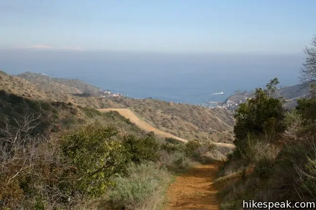
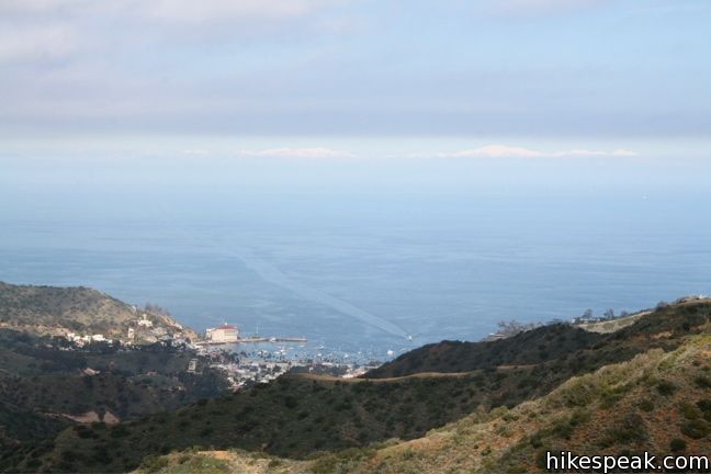
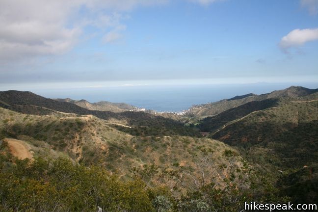
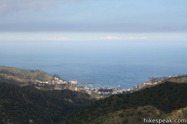
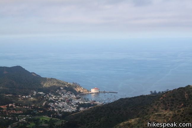
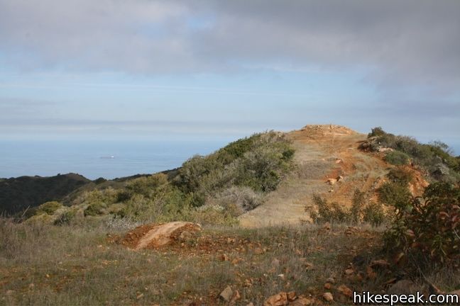
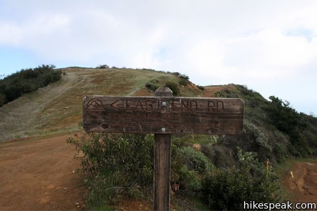
Just past the campground, turn right on Hermit Gulch Trail. A sign here notes the access to the Trans-Catalina Trail. This 1.7-mile long single trail climbs some 1,200 feet to a junction with East Road (a fire road straddling the divide at the southern end of Catalina Island). Hermit Gulch Trail is the steepest part of the hike. Luckily that effort is rewarded by expanding ocean views. The top of the trail offers a breathtaking look over Avalon and the channel beyond.
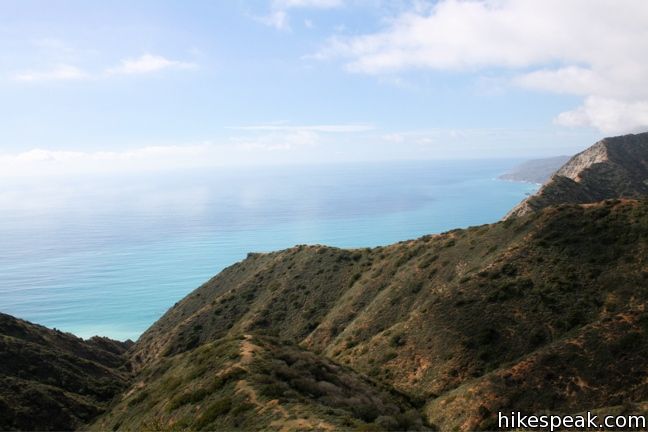
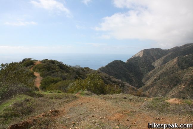
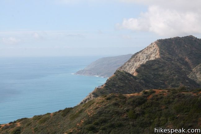
Turn left and start down East Road (Trans-Catalina Trail), where you will be greeted by another ocean view, this one facing west. Look left. Look right. It’s the big blue in both directions.
A footpath breaks off the road to the left, accompanied by a sign marked “Avalon.” Indeed one could descent here to the Botanical Gardens below for a shorter 6.25-mile loop. But the views only improve on East Road, so why turn back now?
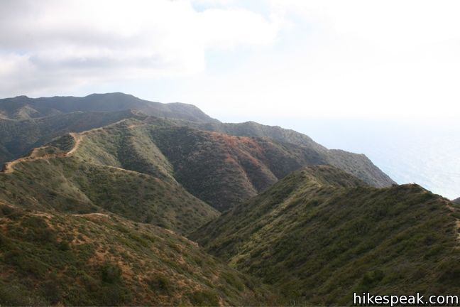
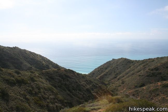
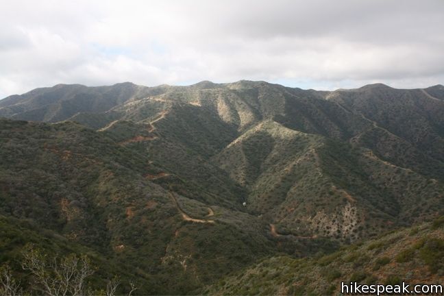
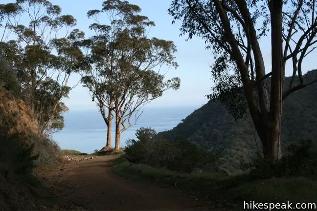
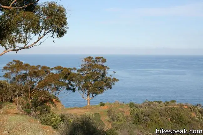
The fire road meanders southward, undulating along the ridge, but never becoming as steep as Hermit Gulch Trail. Simply stay on the fire road as it climbs to an elevation of 1600 feet. The bi-coastal views are extraordinary.
The road bends to the east and heads down to an old junction. Take the fire road heading uphill to the left to stay on the Trans-Catalina Trail, now Renton Mine Road. The road heads north toward Avalon and winds its way down to the sea. When the trail ends at the paved Wrigley Road, one can turn either left or right to return to Avalon.
Turning left, the trail climbs up to Wrigley Terrace passing the Inn on Mount Ada before dropping into Avalon.
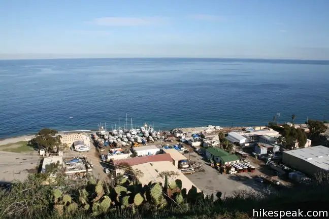
Turning right, the road descends to the industrial sector of Avalon. At road’s end, turn left on Pebbly Beach Road and follow the shoreline back to Avalon. The road passes Lover’s Cove before coming to the port and the city of Avalon.
This long island hike is easy to follow and provides breathtaking views of the southern end of Catalina Island.
A free permit is required to hike on Catalina Island. To obtain a permit, visit the Catalina Island Conservancy on Clarissa Street (located at the starting point on the GPS trace below).
Directions to the Trailhead
- Take a ferry 22-miles across the Pacific to the city of Avalon on Catalina Island.
- Walk through town and up Avalon Canyon Road to Hermit Gulch Campground and the start of the trail.
Trailhead address: 125 Claressa Avenue, Avalon, CA 90704
Trailhead coordinates: 33.3424, -118.32495 (33° 20′ 32.6″N 118° 19′ 29.8″W)
View Catalina Island in a larger map
Or view a regional map of surrounding Los Angeles trails and campgrounds.


 | La Jolla Canyon Loop This 11.75-mile hike explores Point Mugu State Park on the west end of the Santa Monica Mountains, offering extraordinary ocean views. |
 | Parker Mesa Overlook This steep out-and-back hike rewards the effort with excellent views of the Pacific Ocean. |
 | Sandstone Peak This 6.25-mile loop summits the tallest peak in the Santa Monica Mountains. |
 | Zuma Ridge Trail This wide dirt service road which weaves northwest up the back of the ridge west of Zuma Canyon offering access to several trails in the area. |
 | More trails in Los Angeles Explore other destinations around Los Angeles. |
 | Hermit Gulch Campground This 43-site campground on the edge of Avalon sits at the base of Hermit Gulch Trail. |
Common Questions about Hermit Gulch Trail – Trans-Catalina Trail Loop on Santa Catalina Island
- Is the trail open?
- Yes. You should expect to find that Hermit Gulch Trail - Trans-Catalina Trail Loop is open. There are no recent reports of trail closures. If you discover that the trail is closed, please help your fellow hikers by reporting a closure.
- Is this trail free to access?
- Yes, Hermit Gulch Trail - Trans-Catalina Trail Loop is free to access. No entrance fee, pass, or permit is required. If you discover that access rules have changed, please provide feedback on your experience.
- How much time does this hike take?
- It takes approximately 5 hours 45 minutes to hike Hermit Gulch Trail - Trans-Catalina Trail Loop. Individual hiking times vary. Add extra time for breaks and taking in the views.
- How long is this hike?
- The hike to Hermit Gulch Trail - Trans-Catalina Trail Loop is a 11.75 mile loop with 1600 feet of elevation change.
- Are dogs allowed on this trail?
- No, dogs are likely not allowed on Hermit Gulch Trail - Trans-Catalina Trail Loop. The trail is primarily open to hikers.
- Is Hermit Gulch Trail - Trans-Catalina Trail Loop a difficult hike?
- This hike should be considered strenuous. Hikers should be prepared for a workout covering 11.75 miles and 1600 feet of climbing.
- Are there ocean views on this hike?
- Yes, Hermit Gulch Trail - Trans-Catalina Trail Loop offers views of the ocean.
- Where is the trailhead located?
- The trailhead for Hermit Gulch Trail - Trans-Catalina Trail Loop is located in Avalon, CA.
Trailhead Address:
125 Claressa Avenue
Avalon, CA 90704
Trailhead Coordinates:
33.3424, -118.32495 - What are the driving directions to the start of the hike?
- To get to the trailhead: Take a ferry 22-miles across the Pacific to the city of Avalon on Catalina Island. Walk through town and up Avalon Canyon Road to Hermit Gulch Campground and the start of the trail.
View custom Google Maps directions from your current location. - Are there other trails near Hermit Gulch Trail - Trans-Catalina Trail Loop?
- Yes, you can find other nearby hikes using the Hikespeak Hike Finder Map.

I hiked the entire Trans Catalina Trail back in the spring. Springtime is probably the best possible time to do this. It’s not too hot and everything is very green. The wildflowers were insane!
The entire TCT is a tough trek. Lots of up and down. But really beautiful.
Thanks for the idea on the trail route, the wife and I did it for our third anniversary this past weekend. On the downside, the highest points of the hike were up in the clouds, so we didn’t get to have the amazing views, but on the plus side we ran across our first rattlesnake. I’m looking forward to doing it again on a clear day!
Approximately how long does it take to do the Garden to Sky Loop walking to and from Avalon? The permit says it is 5 miles, but I’m not sure how long that might take. Is the trail rigorous? Also, what kind of shoes, clothing would be required in May. I’m guessing hiking boots or tennis shoes, and layers of clothing for weather changes.
Whatever you would normally wear hiking is fine. The road leaving Avalon is easy to walk along. There’s some good elevation on the loop, but the trails aren’t too rigorous. You could certainly do the hike in a few hours.