Willow Springs Loop Pictographs Red Rock Canyon National Conservation Area Las Vegas Nevada Lost Creek Canyon Willow Springs Picnic Area Hike
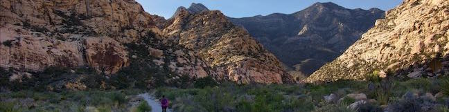
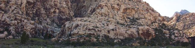
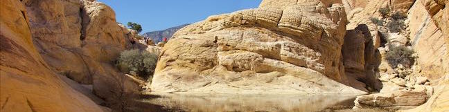
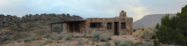
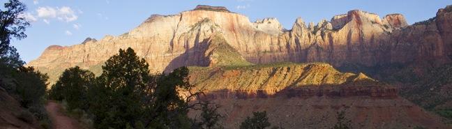
Willow Springs Loop explores an area off the northwest side of the Scenic Drive through Red Rock Canyon National Conservation Area. While it is bordered by steep mountains, the loop actually crosses easy terrain along Red Rock Wash. Visit pictographs left behind by Native American's near Willow Springs Picnic Area and meander through desert landscapes. ...Read more.
My Hikes: Completed hikeA green icon of shows a picture of a landscape with a check mark in the upper right corner, signifying that this is a hike you would like to put on your completed list.OK! Add to trails I've hiked
My Hikes: Want to hikeA green icon of shows a picture of a landscape with a heart in the upper right corner, signifying that this is a hike you would like to put on your to-do list.OK! Add to trails I want to hike
TagsA green icon depicting a tags represents a list of words and phrases that this content is tagged with Tagged with · Bureau of Land Management · Desert Canyons · Las Vegas · Pictographs · Waterfalls
Hike DistanceA green icon of a hiker used to label information about the length of the hike Distance: 1.33 miles · Elevation change: 165 feet
By: Published: Last updated: December 5, 2025
Lost Creek Canyon Trail Red Rock Canyon National Conservation Area Las Vegas Nevada Lost Creek Waterfall
This short hike ventures into a canyon to Lost Creek Waterfall, a seasonal desert falls. Cross through a riparian area below tall cliffs in the Spring Mountains of Red Rock Canyon National Conservation Area. Lost Creek Canyon Trail is 0.35 miles long and can be done as a 0.7-mile out and back hike with 165 feet of elevation change. Form a circuit with Lost Creek Children's Discovery Loop Trail to explore surrounding rock formations (including a pictograph) on a 0. ...Read more.
My Hikes: Completed hikeA green icon of shows a picture of a landscape with a check mark in the upper right corner, signifying that this is a hike you would like to put on your completed list.OK! Add to trails I've hiked
My Hikes: Want to hikeA green icon of shows a picture of a landscape with a heart in the upper right corner, signifying that this is a hike you would like to put on your to-do list.OK! Add to trails I want to hike
TagsA green icon depicting a tags represents a list of words and phrases that this content is tagged with Tagged with · Bureau of Land Management · Desert Canyons · Las Vegas · Waterfalls
Hike DistanceA green icon of a hiker used to label information about the length of the hike Distance: 0.7 miles · Elevation change: 165 feet
By: Published: Last updated: December 5, 2025
Calico Tanks Trail Red Rock Canyon National Conservation Area Las Vegas Nevada Sandstone Quarry Hike to Calico Tanks
Calico Tanks Trail is one of the most popular hikes in Red Rock Canyon National Conservation Area, and for good reason. The trail ventures up a canyon colored in both yellow and red sandstone. Add the gray-blue mountains to the northwest and you get some seriously vibrant views. The trail ends with two rewards, a hopefully-not-dry pond and an overlook of Las Vegas. ...Read more.
My Hikes: Completed hikeA green icon of shows a picture of a landscape with a check mark in the upper right corner, signifying that this is a hike you would like to put on your completed list.OK! Add to trails I've hiked
My Hikes: Want to hikeA green icon of shows a picture of a landscape with a heart in the upper right corner, signifying that this is a hike you would like to put on your to-do list.OK! Add to trails I want to hike
TagsA green icon depicting a tags represents a list of words and phrases that this content is tagged with Tagged with · Bureau of Land Management · Desert Canyons · Las Vegas · Tanks
Hike DistanceA green icon of a hiker used to label information about the length of the hike Distance: 2.5 miles · Elevation change: 420 feet
By: Published: Last updated: December 5, 2025
Mouse's Tank Trail Petroglyphs Canyon Trail Hike to Mouses Tank Valley of Fire State Park Nevada
The best outing for seeing petroglyphs in Valley of Fire State Park is Petroglyph Canyon Trail. This 0.75-mile round trip hike passes rock faces that are covered in Native American rock art. The abundance of prehistoric petroglyphs on this trail is amazing. To cap things off, the trail ends at Mouse's Tank, a natural basin (or tinaja) of water suspended in sandstone. ...Read more.
My Hikes: Completed hikeA green icon of shows a picture of a landscape with a check mark in the upper right corner, signifying that this is a hike you would like to put on your completed list.OK! Add to trails I've hiked
My Hikes: Want to hikeA green icon of shows a picture of a landscape with a heart in the upper right corner, signifying that this is a hike you would like to put on your to-do list.OK! Add to trails I want to hike
TagsA green icon depicting a tags represents a list of words and phrases that this content is tagged with Tagged with · Desert Canyons · Nevada State Parks · Petroglyphs · Tanks
Hike DistanceA green icon of a hiker used to label information about the length of the hike Distance: 0.75 miles · Elevation change: 25 feet
By: Published: Last updated: December 5, 2025
Rock Spring Mojave National Park Rock Spring Loop Trail Rock House Hike
Water is something you don't see much of in Mojave National Preserve, certainly not just pooling on the ground as it does at Rock Spring. The constant source at Rock Spring helped inhabitants survive in the Mojave Desert for thousands of years and was even the site of a small U.S. Army post in the 1860s. Today you can reach the spring easily, along with a Rock House built in the 1920s and the ruins of a mill used by miners, on a 1 1/3-mile loop with 100 feet of elevation change that also features panoramic desert views. ...Read more.
My Hikes: Completed hikeA green icon of shows a picture of a landscape with a check mark in the upper right corner, signifying that this is a hike you would like to put on your completed list.OK! Add to trails I've hiked
My Hikes: Want to hikeA green icon of shows a picture of a landscape with a heart in the upper right corner, signifying that this is a hike you would like to put on your to-do list.OK! Add to trails I want to hike
TagsA green icon depicting a tags represents a list of words and phrases that this content is tagged with Tagged with · Desert Canyons · Free Trails
Hike DistanceA green icon of a hiker used to label information about the length of the hike Distance: 1.33 miles · Elevation change: 100 feet
By: Published: Last updated: December 5, 2025
Watchman Trail Zion National Park hike
The closest trail to the south entrance of Zion Nation Park, and one of the best introductions to Zion, is Watchman Trail. This 3.5-mile lollipop loop climbs 500 feet to a rocky bench on the east side of Zion Canyon. The destination serves up stunning views of a nearby tower named The Watchman and several standout rock formations on the walls of Zion Canyon. ...Read more.
My Hikes: Completed hikeA green icon of shows a picture of a landscape with a check mark in the upper right corner, signifying that this is a hike you would like to put on your completed list.OK! Add to trails I've hiked
My Hikes: Want to hikeA green icon of shows a picture of a landscape with a heart in the upper right corner, signifying that this is a hike you would like to put on your to-do list.OK! Add to trails I want to hike
TagsA green icon depicting a tags represents a list of words and phrases that this content is tagged with Tagged with · Desert Canyons · National Parks · Zion Canyon
Hike DistanceA green icon of a hiker used to label information about the length of the hike Distance: 3.5 miles · Elevation change: 500 feet
By: Published: Last updated: December 5, 2025
Canyon Overlook Trail Zion National Park hike
Rarely is a mile-long hike as action packed and rewarding as Canyon Overlook Trail. The overlook sits on the rim of Pine Creek Canyon, which adjoins Zion Canyon to provide massive views of thousand-foot tall sandstone bluffs. There are ravines and overhangs along the short trail that will keep you entertained along the way. This excellent hike is appealing to all, especially those with limited time in Zion National Park. ...Read more.
My Hikes: Completed hikeA green icon of shows a picture of a landscape with a check mark in the upper right corner, signifying that this is a hike you would like to put on your completed list.OK! Add to trails I've hiked
My Hikes: Want to hikeA green icon of shows a picture of a landscape with a heart in the upper right corner, signifying that this is a hike you would like to put on your to-do list.OK! Add to trails I want to hike
TagsA green icon depicting a tags represents a list of words and phrases that this content is tagged with Tagged with · Desert Canyons · National Parks · Zion Canyon
Hike DistanceA green icon of a hiker used to label information about the length of the hike Distance: 1 mile · Elevation change: 150 feet
By: Published: Last updated: December 5, 2025
Riverside Walk Zion National Park trail river narrows hike
Riverside Walk accesses the notorious narrows north of Zion Canyon, making it one of the most popular trails in Zion National Park. To the end of the trail (at the start of the narrows) and back is a 1.8-mile hike over a level walkway bordering the Virgin River. Those looking to escape the Utah summer heat can leave the trail at any of several river access points to take a refreshing swim. ...Read more.
My Hikes: Completed hikeA green icon of shows a picture of a landscape with a check mark in the upper right corner, signifying that this is a hike you would like to put on your completed list.OK! Add to trails I've hiked
My Hikes: Want to hikeA green icon of shows a picture of a landscape with a heart in the upper right corner, signifying that this is a hike you would like to put on your to-do list.OK! Add to trails I want to hike
TagsA green icon depicting a tags represents a list of words and phrases that this content is tagged with Tagged with · Creeks · Desert Canyons · National Parks · Zion Canyon
Hike DistanceA green icon of a hiker used to label information about the length of the hike Distance: 1.8 miles · Elevation change: 60 feet
By: Published: Last updated: December 5, 2025
Maidenhair Falls Hellhole Canyon Trail Anza-Borrego Desert State Park
Hellhole Canyon is backed up against the San Ysidro Mountains just southwest of the Anza-Borrego Desert State Park Visitor Center in Borrego Springs. The ominously named canyon is home to Maidenhair Falls, a seasonal 20-foot waterfall that makes a refreshing hiking destination on a hot day in the California desert. If you are visiting the park in early spring, or any time rains bring water to Hellhole Canyon, Maidenhair Falls should be on your itinerary. ...Read more.
My Hikes: Completed hikeA green icon of shows a picture of a landscape with a check mark in the upper right corner, signifying that this is a hike you would like to put on your completed list.OK! Add to trails I've hiked
My Hikes: Want to hikeA green icon of shows a picture of a landscape with a heart in the upper right corner, signifying that this is a hike you would like to put on your to-do list.OK! Add to trails I want to hike
TagsA green icon depicting a tags represents a list of words and phrases that this content is tagged with Tagged with · Borrego Springs · California State Parks · Desert Canyons · Free Trails · Oases · Off Trail · San Ysidro Mountains
Hike DistanceA green icon of a hiker used to label information about the length of the hike Distance: 5.5 miles · Elevation change: 1000 feet
By: Published: Last updated: December 5, 2025
Borrego Palm Canyon Trail Anza-Borrego Desert State Park
Borrego Palm Canyon is a wide trench descending west to east down the San Ysidro Mountains just west of Borrego Springs. The creation of Anza-Borrego Desert State Park began in the 1930s with the protection of this palm-filled canyon. The popularity of the trail exploring Borrego Palm Canyon has endured, even as the park has expanded to protect a thousand square miles of southeastern California. ...Read more.
My Hikes: Completed hikeA green icon of shows a picture of a landscape with a check mark in the upper right corner, signifying that this is a hike you would like to put on your completed list.OK! Add to trails I've hiked
My Hikes: Want to hikeA green icon of shows a picture of a landscape with a heart in the upper right corner, signifying that this is a hike you would like to put on your to-do list.OK! Add to trails I want to hike
TagsA green icon depicting a tags represents a list of words and phrases that this content is tagged with Tagged with · Borrego Springs · California State Parks · Desert Canyons · Oases · San Ysidro Mountains
Hike DistanceA green icon of a hiker used to label information about the length of the hike Distance: 3.25 miles · Elevation change: 450 feet
By: Published: Last updated: December 5, 2025

Tag!

You've come to a tag page, one of the blogiest ways to browse hikespeak.com.

Here are some more tags. The most common tags are the big ones at the top of the list. Have a look around. You may also find what you seek with the search feature on the Hike Finder Map.

Free TrailsNational ParksOcean ViewsCalifornia State ParksSummitsWaterfallsTent CampingCreeksLakesNature TrailsAngeles National ForestMalibuAdventure PassCascade RangeNew Zealand Department of ConservationDesert CanyonsOff TrailWildflowersBeachesLos Padres National ForestNew Zealand National ParksMountains Recreation and Conservation AuthoritySan Gabriel Mountains National MonumentGriffith ParkBig SurWheelchair-FriendlyCampervan CampingRuinsSequoia GrovesOregon State ParksLos OsosPacific Crest TrailHydrothermalCavesHollywoodBackpackingMontaña de Oro State ParkAustralian National ParksTopanga State ParkYosemite ValleyRedwood GrovesAltadenaSanta Ynez MountainsSanta Monica Mountains National Recreation AreaTopangaIrish HillsLone PineMalibu Creek State ParkBorrego SpringsAgoura HillsTrail CampArchesBureau of Land ManagementLookout TowersPacific PalisadesBoulderingDeschutes National ForestColumbia River Gorge National Scenic AreaBackbone TrailLavaWest Hills of PortlandMorrosTualatin MountainsArthur's Pass VillageMinesNevada State ParksTongariro National ParkMammoth LakesWalk-in CampingFruitaGrand JunctionArthur's Pass National ParkBendGiant ForestLa Cañada FlintridgeTide PoolsMorro BayCleveland National ForestRotoruaAzusaJohn Muir TrailAccommodationsOvertonArcadiaPasadenaZion CanyonLava TubesGoletaIsland in the SkyCalabasasTasmania's 60 Great Short WalksHot SpringsSanta Lucia MountainsClaremontGaviota State ParkBadlandsVerdugo MountainsBoardwalksGolden Trout WildernessClosedTillamookPhillip IslandAoraki Mount Cook National ParkRainforestsShasta-Trinity National ForestClosed SeasonallyVolcanoesNorthwest PortlandLas VegasSan Bernardino National ForestGrand Canyon of the YellowstoneForest ParkMount CookVolcanoNewbury ParkPetroglyphsGrant GroveGeyser BasinsStairsButtesBrentwoodGifford Pinchot National ForestFreycinet PeninsulaSan Ysidro MountainsColes BayMorro Bay State ParkTopatopa MountainsThousand OaksPalos Verdes PeninsulaSand DunesOakhurstOnondaga CountyAdirondack ParkAdirondack MountainsMorterosGiant Sequoia National MonumentAnsel Adams WildernessOhakuneOjaiMemorialsFreycinet National ParkLighthousesJohn Muir WildernessTasman PeninsulaTrabuco Ranger DistrictSan Bernardino MountainsWestern DivideSanta Ana MountainsSilver Moccasin TrailOrange County ParksPoint Mugu State ParkWestridge-Canyonback Wilderness ParkPaicinesSunriverWestern Divide Ranger DistrictNatural BridgesWill Rogers State ParkCratersNelder GroveTopanga CanyonStevensonWhakapapa VillageLava Butte Lava FlowWashington State ParksMount Hood National ForestCastle Crags State ParkMount ShastaThree Capes Scenic RouteNewberry National Volcanic MonumentWater SlidesMount HoodTarzanaContinental DivideSouth Lake TahoeSistersHobartReservoir Canyon Natural ReserveDomesPfeiffer Big Sur State ParkHumboldt Redwoods State ParkSouthwest PortlandOasesLeo Carrillo State ParkMoabGovernment CampNewhallLaguna BeachJulianSouth Coast WildernessTemescal Gateway ParkSilver Falls State ParkCambriaHutsSublimityGlacier LakesCliff JumpingGoing-to-the-Sun RoadPearblossomMontecitoHawaii State ParksKlamath MountainsSpringvilleRancho Palos VerdesWawonaDeschutes RiverCamp ShermanWildlife ViewingBeacon Rock State ParkLos Robles Open SpaceTanksYellowstone RiverSan Vicente Mountain ParkSwimming HolesObservatoriesIdyllwildSan Jacinto Ranger DistrictWaiotapuBurbankPalomar Ranger DistrictCalifornia Coastal TrailTasman National ParkLabrador Hollow Unique AreaCortland CountyTullyNew York State ForestsMount William National ParkVestalPicnic AreaWind CavesSan Jacinto MountainsSilver Peak WildernessBinghamton University Nature PreserveCedar GroveBlack HillsAvila BeachJulia Pfeiffer Burns State ParkCinder ConesLake ElsinoreMurrietaWenatche National ForestElephant SealsGlendaleSnowshoeingSan Mateo Canyon WildernessWilsons Promontory National ParkCrestlineEmma Wood State BeachWhananaki NorthCarpinteriaPlacerita Canyon Natural AreaPlacerita Canyon State ParkBike TrailSan PedroTujungaSanta Susana MountainsNew York State ParksSun ValleyCrescent CityRedwood Mountain GroveBishop Peak Natural ReserveAvila ValleySimi HillsSheep Mountain WildernessCrystal Cove State ParkSierra Pelona MountainsSanta MargaritaBeverly HillsConejo ValleyBlue Mountain LakeNicholas Flat Natural PreserveHume Lake Ranger DistrictGlaciersTe AwamutuRangitikeiSummit ValleySummit Valley Edmund D. Edelman ParkFish HatcheryWoodland HillsCastle Crags WildernessPepperwoodTryon Creek State Natural AreaTaurangaTaupoLodgeSanta PaulaTwentynine PalmsSherman OaksWillamette National ForestSouthern AlpsPortlandMount Thomas Forest Conservation AreaOkukuCusterCal PolyMacleay ParkWaimangu Volcanic ValleyPictographsOkere Falls Scenic ReserveOkere FallsArroyo GrandeMarvin Braude Mulholland Gateway ParkHood RiverEaglehawk NeckCampervan ReviewMount WellingtonWellington ParkTree MoldsLauncestonWaipio ValleyAndrew Molera State ParkCatalina IslandLimekiln State ParkHiloMount Field National ParkBritzRichardson Grove Redwoods State ParkColumbia River GorgeLake Tahoe Basin National Forest LandsPuakoCampervan RentalRocky MountainsLyleSaltwater RiverDeschutes River State Recreation AreaBlowholesWascoLord of the RingsBoat CruiseHarmony Headlands State ParkCayucosSanta Clarita Woodlands ParkAgua DulceCrazy Horse MemorialMonrovia Canyon ParkMonroviaRefugio State BeachPrimitive CampingSatellite CommunicatorsSOS BeaconsMount MaunganuiCulver CityHigh LineMatamataMount San Jacinto State ParkSan Jacinto WildernessMuruparaBanningFiscalini Ranch PreserveKings CanyonWhitewater RaftingTop 10 Holiday ParkPapamoaAerial GreenwayManhattanGPS NavigatorsPalomar MountainsAmboy Crater National Natural LandmarkPetrified LogsPowell Butte Nature ParkSoutheast PortlandBig Bear LakeCross Country SkiingCarpinteria Salt Marsh Nature ParkSonoraCarpinteria Bluffs Nature PreserveLas CrucesVentura RiverPilot Butte State ParkOak ParkMount Lowe RailwayLaguna Coast Wilderness ParkWarner SpringsOrangePeters Canyon Regional ParkSanta Lucia WildernessCarpinteria Seal SanctuaryGetty View ParkHearst San Simeon State ParkMalibu Lagoon State BeachKura Tawhiti / Castle Hill Conservation AreaCastle HillCentral ParkHuntington BeachAwbrey ButteHobbitonLiffeyFallbrookBerriedaleVasquez Rocks Natural Area ParkJamesvilleClark Reservation State ParkBeaver Lake Nature CenterBaldwinsvilleOnondaga County ParkWhitewater PreserveDocent-led HikesPlaya VistaAnaheimCataract Gorge ReserveSan SimeonTauwhara BayLiffey Falls State ReserveGreat Western TiersCape Woolamai State Faunal ReserveKoalasSaint Columba Falls State ReservePyenganaFallbrook Land ConservancyHokianga HarbourDouglas-Apsley National ParkBechinoOtamure BayOtamure Recreation ReserveYucca ValleySan Rafael HillsApp ReviewGuy W. Talbot State ParkEugeneMission Trails Regional ParkTurangiSanteeSanta Rosa and San Jacinto Mountains National MonumentGreen Lakes State ParkFayettevilleConcretionsMangawekaHuntervilleBel AirNewport BeachNewport BayJedediah Smith Redwoods State ParkSantiago Oaks Regional ParkMacKerricher State ParkSalt Point State ParkWeir Canyon Wilderness ParkB&BEl Capitán State BeachFreeride TrailsWest HillsBackpackers LodgeUpper Newport Bay Nature PreserveLake Tikitapu Scenic ReserveMotor LodgeSespe WildernessMyers FlatKlamath National ForestSeasideBaldwin Hills Scenic Overlook State ParkLaCrosseLas Virgines View ParkPalouse Falls State ParkArcoEl Chorro Regional ParkOregon CityWillamette RiverHappy ValleyCamassia Natural AreaWest LinnMontagueWeedCorbettGeorge Himes Nature ParkWeottOrickFort BraggJennerWhite SalmonCamasLacamas Lake Regional ParkPrairie Creek Redwoods State ParkMcKenzie BridgeDuartePalos Verdes EstatesThe Nature ConservancyLincoln CityDepoe BayCooke CityClatskanieGlenbrookCarson CityDevils TowerLake MichiganTuna Canyon ParkWelchesRhododendronOceansideNative American HeritageBass LakeStroller-FriendlyBisonDunsmuirSiletz Bay National Wildlife RefugeSanta ClaritaFishpondsKonaCastaicKohala Forest ReserveKenneth Hahn State Recreation AreaHonomuHollywood HillsStudio CityPu‘uhonua O Hōnaunau National Historical ParkHonaunauLongridge ParkYurtsBreaCape Meares State ParkArroyo Sequit ParkOceano Dunes State Vehicular Recreation AreaCape Lookout State ParkNipomoCannon BeachEldorado State ParkColorado State ParksBoulderMarquam Nature ParkShasta LakeCalaveras Big Trees State ParkMojave Trails National MonumentAtascaderoCape Kiwanda Natural AreaCucamonga WildernessPacific CityCarbon Canyon Regional ParkCape Meares State Scenic ViewpointEcola State ParkMosierSimi ValleyCanoe & KayakAdirondack High PeaksMonserate Mountain PreserveTumalo CreekMaricopaShevlin ParkKlamathPortervilleTualatin Hills Nature ParkBeavertonGarbervilleUpper Ojai ValleyArchie Briggs Natural AreaArboretumsPismo BeachAmboySan BernardinoSkyforestCascade LocksLake ArrowheadLake Placid