Cottonwood Lakes Trail Inyo National Forest John Muir Wilderness Sierra lake hike
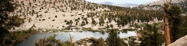
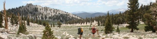
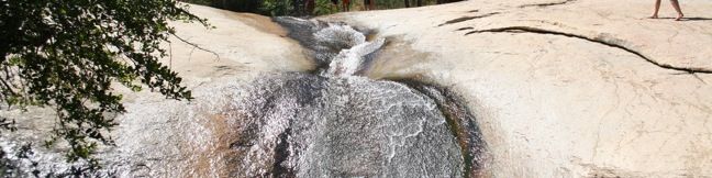
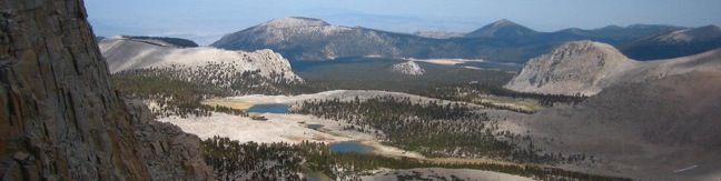
Cottonwood Lakes Trail provides a scenic romp through the Southeastern Sierra with alpine lakes and mountain views. Located south of Mount Whitney and west of the city of Lone Pine, the trail travels through the Golden Trout Wilderness and the John Muir Wilderness to end at the border of Sequoia National Park. This is a superb trail for day hikers and backpackers alike. ...Read more.
My Hikes: Completed hikeA green icon of shows a picture of a landscape with a check mark in the upper right corner, signifying that this is a hike you would like to put on your completed list.OK! Add to trails I've hiked
My Hikes: Want to hikeA green icon of shows a picture of a landscape with a heart in the upper right corner, signifying that this is a hike you would like to put on your to-do list.OK! Add to trails I want to hike
TagsA green icon depicting a tags represents a list of words and phrases that this content is tagged with Tagged with · Creeks · Free Trails · Golden Trout Wilderness · John Muir Wilderness · Lakes · Lone Pine
Hike DistanceA green icon of a hiker used to label information about the length of the hike Distance: 15 miles · Elevation change: 2350 feet
By: Published: September 21, 2010 Last updated: January 16, 2018
Chicken Spring Lake Trail Golden Trout Wilderness Inyo National Forest Hike Sierra Nevada Mountains Cottonwood Pass
This mountain lake is 0.6 miles from Cottonwood Pass, making it an easy 8.2-mile round trip hike from Horseshoe Meadow. With just 1,330 feet of elevation gain en route to the lake, this is a desirable destination for day-hikers and a good first camp for backpackers. Follow Cottonwood Pass Trail to a junction at the pass with Pacific Crest Trail. Turn right and continue through a rocky forest of Foxtail Pines. ...Read more.
My Hikes: Completed hikeA green icon of shows a picture of a landscape with a check mark in the upper right corner, signifying that this is a hike you would like to put on your completed list.OK! Add to trails I've hiked
My Hikes: Want to hikeA green icon of shows a picture of a landscape with a heart in the upper right corner, signifying that this is a hike you would like to put on your to-do list.OK! Add to trails I want to hike
TagsA green icon depicting a tags represents a list of words and phrases that this content is tagged with Tagged with · Free Trails · Golden Trout Wilderness · Lakes · Lone Pine · Pacific Crest Trail
Hike DistanceA green icon of a hiker used to label information about the length of the hike Distance: 8.2 miles · Elevation change: 1330 feet
By: Published: September 17, 2010 Last updated: December 21, 2017
eastern sierra campground lone pine Horseshoe Meadow Inyo National Forest Cottonwood Golden Trout Wilderness Horseshoe Meadow Campground Cottonwood Lakes Campground
Cottonwood Pass Trail and Cottonwood Lakes Trail provide great portals into Inyo National Forest and Sequoia National Park. Hiking begins at an elevation of 10,000 feet, providing a launch pad into the high sierra. Because you start so high up, acclimating is a key to avoiding altitude sickness. For this reason, a pair of first-come first-serve campgrounds offer a valuable resource for hikers. ...Read more.
TagsA green icon depicting a tags represents a list of words and phrases that this content is tagged with Tagged with · Golden Trout Wilderness · Lone Pine · Tent Camping
By: Published: September 16, 2010 Last updated: January 7, 2019
Cottonwood Pass Trail Golden Trout Wilderness hike backpacking Sierra trails
At an elevation of 11,200 feet, Cottonwood Pass serves as a gateway to the Golden Trout Wilderness and Sequoia National Park. The pass is reached via a 3.5-mile one way trail from Horseshoe Meadow, which has an elevation of 10,000 feet, making this is one of the easiest passes for hikers to reach in the Eastern Sierra. A view of Trail Peak from Horseshoe Meadow Pick up the trail at Horsehoe Meadow Campground and begin hiking east over packed sand along the northern edge of Horseshoe Meadow. ...Read more.
My Hikes: Completed hikeA green icon of shows a picture of a landscape with a check mark in the upper right corner, signifying that this is a hike you would like to put on your completed list.OK! Add to trails I've hiked
My Hikes: Want to hikeA green icon of shows a picture of a landscape with a heart in the upper right corner, signifying that this is a hike you would like to put on your to-do list.OK! Add to trails I want to hike
TagsA green icon depicting a tags represents a list of words and phrases that this content is tagged with Tagged with · Free Trails · Golden Trout Wilderness · Lone Pine · Pacific Crest Trail
Hike DistanceA green icon of a hiker used to label information about the length of the hike Distance: 7 miles · Elevation change: 1200 feet
By: Published: September 16, 2010 Last updated: January 16, 2018
Sequoia National Forest Water Slide trail waterslide hike Western Divide Ranger District Sierra Nevada Mountains
On a hot summer day in the Sierra, what could be better than a cool water slide? Answer: a natural water slide. Fortunately, Giant Sequoia National Monument is nice enough to offer one. However, you wouldn't know it from the park literature. Nature's slip-n-slide goes unmentioned in handouts and websites. For that reason, many visitors miss out on this unadvertised attraction. ...Read more.
My Hikes: Completed hikeA green icon of shows a picture of a landscape with a check mark in the upper right corner, signifying that this is a hike you would like to put on your completed list.OK! Add to trails I've hiked
My Hikes: Want to hikeA green icon of shows a picture of a landscape with a heart in the upper right corner, signifying that this is a hike you would like to put on your to-do list.OK! Add to trails I want to hike
TagsA green icon depicting a tags represents a list of words and phrases that this content is tagged with Tagged with · Creeks · Free Trails · Giant Sequoia National Monument · Springville · Water Slides · Western Divide · Western Divide Ranger District
Hike DistanceA green icon of a hiker used to label information about the length of the hike Distance: 1.5 miles · Elevation change: 150 feet
By: Published: June 21, 2010 Last updated: May 13, 2025