Alcove Nature Trail in Colorado National Monument near Grand Junction Colorado
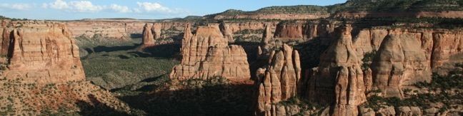
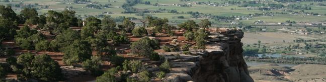
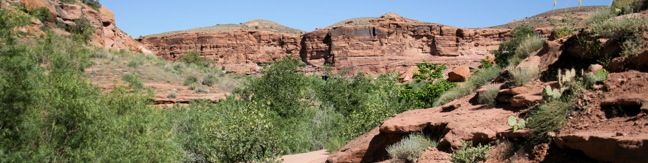
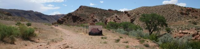
Across the road from the park visitor center (and Canyon Rim Trail) is Alcove Nature Trail. This track is set back from the canyon rim, which limits views of the great landscape. What this trail offers instead is an informative hike with numbered markers that coincide with entries in a guide booklet. The entries describe plants and animals in the park as well as the geological history. ...Read more.
My Hikes: Completed hikeA green icon of shows a picture of a landscape with a check mark in the upper right corner, signifying that this is a hike you would like to put on your completed list.OK! Add to trails I've hiked
My Hikes: Want to hikeA green icon of shows a picture of a landscape with a heart in the upper right corner, signifying that this is a hike you would like to put on your to-do list.OK! Add to trails I want to hike
TagsA green icon depicting a tags represents a list of words and phrases that this content is tagged with Tagged with · Desert Canyons · Fruita · Grand Junction · Nature Trails
Hike DistanceA green icon of a hiker used to label information about the length of the hike Distance: 1 mile · Elevation change: 175 feet
By: Published: Last updated: July 24, 2025
Canyon Rim Trail Colorado National Monument
For a view of Praying Hands, Independence Monument, and the other statuesque monoliths in Monument Canyon, take a stroll along Canyon Rim Trail. The track crosses the canyon rim between Saddlehorn Visitor Center and Book Cliff View, and is a great way to begin your visit of Colorado National Monument. The trail is half a mile one-way or one mile round trip. ...Read more.
My Hikes: Completed hikeA green icon of shows a picture of a landscape with a check mark in the upper right corner, signifying that this is a hike you would like to put on your completed list.OK! Add to trails I've hiked
My Hikes: Want to hikeA green icon of shows a picture of a landscape with a heart in the upper right corner, signifying that this is a hike you would like to put on your to-do list.OK! Add to trails I want to hike
TagsA green icon depicting a tags represents a list of words and phrases that this content is tagged with Tagged with · Desert Canyons · Fruita · Grand Junction
Hike DistanceA green icon of a hiker used to label information about the length of the hike Distance: 1 mile · Elevation change: 100 feet
By: Published: Last updated: July 24, 2025
Window Rock Trail in Colorado National Monument Colorado hiking Window Rock Trail begins next to Bookcliff Shelter, not far from Saddlehorn Campground. The trail looks south into Monument Canyon and north over the cities below. This 1/3-mile round trip hike ends at a distinct point at the north end of the western wall of Monument Canyon where a natural window pierces the top of the cliff.
Window Rock Trail begins next to Bookcliff Shelter, not far from Saddlehorn Campground. The trail looks south into Monument Canyon and north over the cities below. This 1/3-mile round trip hike ends at a distinct point at the north end of the western wall of Monument Canyon where a natural window pierces the top of the cliff. Window Rock Window Rock Trail is wide and easy to follow, descending gradually about 60 vertical feet through a forest of Pinyon pines and Utah junipers. ...Read more.
My Hikes: Completed hikeA green icon of shows a picture of a landscape with a check mark in the upper right corner, signifying that this is a hike you would like to put on your completed list.OK! Add to trails I've hiked
My Hikes: Want to hikeA green icon of shows a picture of a landscape with a heart in the upper right corner, signifying that this is a hike you would like to put on your to-do list.OK! Add to trails I want to hike
TagsA green icon depicting a tags represents a list of words and phrases that this content is tagged with Tagged with · Desert Canyons · Fruita · Grand Junction
Hike DistanceA green icon of a hiker used to label information about the length of the hike Distance: 0.35 miles · Elevation change: 60 feet
By: Published: Last updated: July 24, 2025
Rim Rock Drive scenic road overlooks viewpoints vista points in Colorado National Monument
Rim Rock Drive is a 23-mile stretch of road crossing the rugged terrain of Colorado National Monument. The drive delivers dizzying cliff's edge views and is a memorable part of any visit to the park. The winding roadway plots an improbable course along the rim of Monument Canyon. Nineteen overlooks and fourteen trails are along the drive, which is the main artery through the park. ...Read more.
TagsA green icon depicting a tags represents a list of words and phrases that this content is tagged with Tagged with · Desert Canyons · Fruita · Grand Junction
By: Published: Last updated: July 1, 2025
Balanced Rock Colorado National Monument
Balanced Rock is a natural attractions in Colorado National Monument, similar to Balanced Rock in Arches National Park. The defiant sandstone statue stands at the edge of a bluff and is easy to see from a turnout along Rim Rock Drive. Those entering the park through the west entrance near the city of Fruita, should make Balanced Rock View their first stop. ...Read more.
TagsA green icon depicting a tags represents a list of words and phrases that this content is tagged with Tagged with · Fruita · Grand Junction
By: Published: Last updated: April 19, 2018
Saddlehorn Campground Colorado National Monument
Saddlehorn Campground is the only campground in Colorado National Monument, and is well located within the park. This 80-site campground is adjacent to the park visitor center and several hiking options are nearby, including Window Rock Trail, Alcove Nature Trail, and Canyon Rim Trail. Saddlehorn Campground is situated on a high bluff overlooking the cities of Fruita and Redlands to the north. ...Read more.
TagsA green icon depicting a tags represents a list of words and phrases that this content is tagged with Tagged with · Fruita · Grand Junction · Tent Camping
By: Published: Last updated: February 5, 2025
Moab Campgrounds Utah Bureau of Land Management Camping Areas
If you are visiting Arches or Canyonlands and are planning to camp, you should know that camping within these national parks is quite limited. Fortunately, the Bureau of Land Management operates over two dozen developed campgrounds (with over 400 individual sites) outside these parks around the city of Moab. Each of the BLM campgrounds are first-come first-serve, so it is best to arrive early and plan ahead. ...Read more.
TagsA green icon depicting a tags represents a list of words and phrases that this content is tagged with Tagged with · Bureau of Land Management · Moab · Tent Camping
By: Published: Last updated: June 29, 2025
Utah Hikes Negro Bill Canyon Trail Morning Glory Bridge hike Colorado River Moab Utah Hike
This 4.65-mile round trip hike starts above the banks of the Colorado River east of Moab, Utah, and travels up a scenic canyon alongside a much smaller stream. The trek terminates at a stunning 243-foot long natural bridge, the sixth largest natural rock span in America. The level dirt trail to Morning Glory Bridge ascends just 300 feet and offers plenty of serenity along the way. ...Read more.
My Hikes: Completed hikeA green icon of shows a picture of a landscape with a check mark in the upper right corner, signifying that this is a hike you would like to put on your completed list.OK! Add to trails I've hiked
My Hikes: Want to hikeA green icon of shows a picture of a landscape with a heart in the upper right corner, signifying that this is a hike you would like to put on your to-do list.OK! Add to trails I want to hike
TagsA green icon depicting a tags represents a list of words and phrases that this content is tagged with Tagged with · Bureau of Land Management · Creeks · Desert Canyons · Free Trails · Moab · Natural Bridges
Hike DistanceA green icon of a hiker used to label information about the length of the hike Distance: 4.65 miles · Elevation change: 300 feet
By: Published: Last updated: February 10, 2020
Hike Utah Moab Mill Creek Trail Swimming Hole Hike cliff jumping Moab Utah
If you visit Arches or Canyonlands National Parks in the summer, you may be greeted by long days with temperatures in the triple digits. In those conditions, a simply swim in a cold creek can be as satisfying as any of those parks' amazing landmarks. The Colorado River around Moab is swift and silty, so instead bathe in the refreshing waters of Mill Creek. ...Read more.
My Hikes: Completed hikeA green icon of shows a picture of a landscape with a check mark in the upper right corner, signifying that this is a hike you would like to put on your completed list.OK! Add to trails I've hiked
My Hikes: Want to hikeA green icon of shows a picture of a landscape with a heart in the upper right corner, signifying that this is a hike you would like to put on your to-do list.OK! Add to trails I want to hike
TagsA green icon depicting a tags represents a list of words and phrases that this content is tagged with Tagged with · Bureau of Land Management · Cliff Jumping · Creeks · Moab · Water Slides · Waterfalls
Hike DistanceA green icon of a hiker used to label information about the length of the hike Distance: 0.5 miles · Elevation change: 50 feet
By: Published: Last updated: February 26, 2024
Hiking Arches North and South Window Arch Turret Arch Utah North and South Window Arch and Turret Arch Loop Arches National Park
This one-mile loop visits three impressive arches in close vicinity. The North and South Window Arches form openings in the same sandstone fin, while Turret Arch stands within a more castle-like formation. The circle between the arches has three spurs leading to the base of each arch, creating an action-packed hike with just 150 feet of elevation gain. ...Read more.
My Hikes: Completed hikeA green icon of shows a picture of a landscape with a check mark in the upper right corner, signifying that this is a hike you would like to put on your completed list.OK! Add to trails I've hiked
My Hikes: Want to hikeA green icon of shows a picture of a landscape with a heart in the upper right corner, signifying that this is a hike you would like to put on your to-do list.OK! Add to trails I want to hike
TagsA green icon depicting a tags represents a list of words and phrases that this content is tagged with Tagged with · Arches · National Parks
Hike DistanceA green icon of a hiker used to label information about the length of the hike Distance: 1 mile · Elevation change: 150 feet
By: Published: Last updated: February 10, 2020