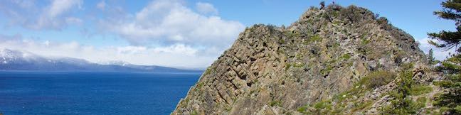
Chimney Beach Trail Lake Tahoe Nevada Chimney Beach Hike Humboldt-Toiyabe National Forest
Before your visit to Lake Tahoe goes up in smoke, take a hike to Chimney Beach - where a standing-on-its-own fireplace and chimney serve as an unsual landmark for a lovely little cove. The brick chimney is all that's left of an old cabin built in the sand between boulder-strewn points on the east shore of Lake Tahoe. If curiosity about the chimney draws you to Chimney Beach, the beautiful lake views and clear turquoise water will be what keeps you hanging around. ...Read more.
My Hikes: Completed hikeA green icon of shows a picture of a landscape with a check mark in the upper right corner, signifying that this is a hike you would like to put on your completed list.OK! Add to trails I've hiked
My Hikes: Want to hikeA green icon of shows a picture of a landscape with a heart in the upper right corner, signifying that this is a hike you would like to put on your to-do list.OK! Add to trails I want to hike
TagsA green icon depicting a tags represents a list of words and phrases that this content is tagged with Tagged with · Beaches · Carson City · Free Trails · Ruins · South Lake Tahoe
Hike DistanceA green icon of a hiker used to label information about the length of the hike Distance: 1.1 miles · Elevation change: 215 feet
By: Published: Last updated: July 25, 2025
Cave Rock Trail Lake Tahoe Nevada Overlook Hike
Gaze out from Route 50 as it travels along the southeast side of Lake Tahoe and you'll find nice views of the lakeshore and its surrounding mountains. Seven miles up from the state border in South Lake Tahoe, Nevada Route 50 slips through a tunnel in a tall pointed ridge of volcanic rock. The road itself is scenic, but the sight of Cave Rock should have you speculating how superb things must look from the top. ...Read more.
My Hikes: Completed hikeA green icon of shows a picture of a landscape with a check mark in the upper right corner, signifying that this is a hike you would like to put on your completed list.OK! Add to trails I've hiked
My Hikes: Want to hikeA green icon of shows a picture of a landscape with a heart in the upper right corner, signifying that this is a hike you would like to put on your to-do list.OK! Add to trails I want to hike
TagsA green icon depicting a tags represents a list of words and phrases that this content is tagged with Tagged with · Free Trails · Glenbrook · South Lake Tahoe · Summits
Hike DistanceA green icon of a hiker used to label information about the length of the hike Distance: 0.9 miles · Elevation change: 165 feet
By: Published: Last updated: September 11, 2024
Crater Rim Drive Hike Keanakakoi Crater Keanakakoi Overlook Trail Keanakako'i Crater Hike Hawaii Volcanoes National Park Big Island Kilauea Summit
In the summer of 2018, Hawaiʻi Volcanoes National Park experienced the most dramatic volcanic activity in it's more than century long history. Land considered stable was humbled and demolished. When the earth stopped exploding and when the shaking of 60,000 earthquakes ceased, Crater Rim Drive, the road that ringed Kīlauea, was ruined in many places. ...Read more.
My Hikes: Completed hikeA green icon of shows a picture of a landscape with a check mark in the upper right corner, signifying that this is a hike you would like to put on your completed list.OK! Add to trails I've hiked
My Hikes: Want to hikeA green icon of shows a picture of a landscape with a heart in the upper right corner, signifying that this is a hike you would like to put on your to-do list.OK! Add to trails I want to hike
TagsA green icon depicting a tags represents a list of words and phrases that this content is tagged with Tagged with · National Parks · Volcano · Volcanoes
Hike DistanceA green icon of a hiker used to label information about the length of the hike Distance: 2.15 miles · Elevation change: 100 feet
By: Published: Last updated: May 13, 2025
Kipukapuaulu Trail Forest Hike Nature Trail Loop Hawaii Volcanoes National Park
Filled with bold volcanic features and landscapes reinvented by eruptions, Hawaiʻi Volcanoes National Park might seem an unlikely place to find a deep-rooted forest packed with plant diversity and a thriving bird population. Kīpukapuaulu rises like an oasis, framed the less-fertile lands forged by more recent lava flows. Kīpukapuaulu Trail is a 1. ...Read more.
My Hikes: Completed hikeA green icon of shows a picture of a landscape with a check mark in the upper right corner, signifying that this is a hike you would like to put on your completed list.OK! Add to trails I've hiked
My Hikes: Want to hikeA green icon of shows a picture of a landscape with a heart in the upper right corner, signifying that this is a hike you would like to put on your to-do list.OK! Add to trails I want to hike
TagsA green icon depicting a tags represents a list of words and phrases that this content is tagged with Tagged with · National Parks · Nature Trails · Volcano · Volcanoes
Hike DistanceA green icon of a hiker used to label information about the length of the hike Distance: 1.2 miles · Elevation change: 185 feet
By: Published: Last updated: June 13, 2019
Tree Molds Hawaii Volcanoes National Park Lava Tree Molds Hawaii
Trees grow big and strong, but they are outmatched by the forces of lava. A tree's last stand against a lava flow can result in a tree mold - a hole in the surface of hardened lava where a tree once stood. Tree molds provide information about lava flows and preceeeding forests. See tree molds with your own eyes at a spot near the entrance of Hawai‘i Volcanoes National Park. ...Read more.
TagsA green icon depicting a tags represents a list of words and phrases that this content is tagged with Tagged with · Lava · Tree Molds · Volcano · Volcanoes
By: Published: Last updated: July 2, 2021
Sulphur Banks Trail Kilauea Crater Rim Trail Loop Hawaii Volcanoes National Park Hike Hawaii
Kīlauea Volcano underwent major transformations when it erupted in the summer of 2018. See changed landscapes in and around Kīlauea Caldera from Steaming Bluff, where steam escapes from hot spots just below your feet! Behind the bluff, a hydrothermal area called Sulphur Banks displays colorful mineral deposits, accompanied by eggy smells. Sulphur Banks Trail – Crater Rim Trail Loop starts from Kīlauea Visitor Center, takes a boardwalk through the Sulphur Banks, stops at Steaming Bluff, and then circles back through rainforest along Crater Rim Trail. ...Read more.
My Hikes: Completed hikeA green icon of shows a picture of a landscape with a check mark in the upper right corner, signifying that this is a hike you would like to put on your completed list.OK! Add to trails I've hiked
My Hikes: Want to hikeA green icon of shows a picture of a landscape with a heart in the upper right corner, signifying that this is a hike you would like to put on your to-do list.OK! Add to trails I want to hike
TagsA green icon depicting a tags represents a list of words and phrases that this content is tagged with Tagged with · Hydrothermal · National Parks · Nature Trails · Volcano · Volcanoes
Hike DistanceA green icon of a hiker used to label information about the length of the hike Distance: 1.6 miles · Elevation change: 50 feet
By: Published: Last updated: October 21, 2025
Holei Sea Arch Trail Hawaii Volcanoes National Park Basalt Arch Pacific Ocean Sea Arch Hike Chain of Craters Road Hawaii
Hawai‘i Volcanoes National Park protects a changing landscape. This is true from the eruptive developments at Kīlauea Caldera all the way down to the ocean erosion at Hōlei Sea Arch. How much longer will this 90-foot tall bridge of basalt withstand the surf? Take a short walk - 100 yards each way - to Hōlei Sea Arch and see it while you can! Hōlei Sea Arch is 22 scenic miles from Kīlauea Visitor Center at the bottom of Chain of Craters Road. ...Read more.
My Hikes: Completed hikeA green icon of shows a picture of a landscape with a check mark in the upper right corner, signifying that this is a hike you would like to put on your completed list.OK! Add to trails I've hiked
My Hikes: Want to hikeA green icon of shows a picture of a landscape with a heart in the upper right corner, signifying that this is a hike you would like to put on your to-do list.OK! Add to trails I want to hike
TagsA green icon depicting a tags represents a list of words and phrases that this content is tagged with Tagged with · Arches · National Parks · Ocean Views · Volcano
Hike DistanceA green icon of a hiker used to label information about the length of the hike Distance: 0.1 miles · Elevation change: 15 feet
By: Published: Last updated: June 13, 2019
Pu'u Loa Petroglyphs Trail Hawaii Volcanoes National Park Boardwalk Hike Big Island Hawaiian Rock Carvings
Pu‘u Loa Petroglyphs Trail puts recent geological history and human history on full display. This level 1.4-mile hike crosses a pahoehoe lava flow to a boardwalk loop through an exciting area with thousands of petroglyphs carved by early Hawaiians. The petroglyphs honor the births of those that lived here hundreds of years ago. This short trek in Hawai‘i Volcanoes National Park is sure to inspire curiosity in the not-so-distant past. ...Read more.
My Hikes: Completed hikeA green icon of shows a picture of a landscape with a check mark in the upper right corner, signifying that this is a hike you would like to put on your completed list.OK! Add to trails I've hiked
My Hikes: Want to hikeA green icon of shows a picture of a landscape with a heart in the upper right corner, signifying that this is a hike you would like to put on your to-do list.OK! Add to trails I want to hike
TagsA green icon depicting a tags represents a list of words and phrases that this content is tagged with Tagged with · National Parks · Petroglyphs · Volcano
Hike DistanceA green icon of a hiker used to label information about the length of the hike Distance: 1.4 miles · Elevation change: 25 feet
By: Published: Last updated: May 13, 2025
Royal Ground Puuhonua Place of Refuge Loop Puuhonua o Honahnah National Historical Park Big Island of Hawaii
To walk through Hawaiian history, head to Pu‘uhonua O Hōnaunau National Historical Park, located on the west coast of the Big Island of Hawai‘i, south of Kona. A convenient hiking trail weaves through the park's Royal Grounds and the Pu‘uhonua (place of refuge). This half-mile long loop passes sixteen numbered markers that correspond with entries in a park brochure to put an educational spin to the scenic surroundings. ...Read more.
My Hikes: Completed hikeA green icon of shows a picture of a landscape with a check mark in the upper right corner, signifying that this is a hike you would like to put on your completed list.OK! Add to trails I've hiked
My Hikes: Want to hikeA green icon of shows a picture of a landscape with a heart in the upper right corner, signifying that this is a hike you would like to put on your to-do list.OK! Add to trails I want to hike
TagsA green icon depicting a tags represents a list of words and phrases that this content is tagged with Tagged with · Honaunau · National Parks · Nature Trails · Ocean Views · Pu‘uhonua O Hōnaunau National Historical Park
Hike DistanceA green icon of a hiker used to label information about the length of the hike Distance: 0.5 miles · Elevation change: 15 feet
By: Published: Last updated: September 13, 2025
Kaumana Caves Lava Tube Park Hilo Big Island Hawaii
The Big Island of Hawai‘i is a dynamic land, where you can find a lava tube on the edge of the island's main city. An 1881 lava flow from Mauna Loa stopped just short of Hilo. Venture up and down a lava tube created by that flow. Enter through a collapsed skylight at Kaumana Caves Park and start exploring. While the entire tube may measure over twenty miles long, visitors can expect to see somewhere under two miles from the Kaumana Caves entrance. ...Read more.
My Hikes: Completed hikeA green icon of shows a picture of a landscape with a check mark in the upper right corner, signifying that this is a hike you would like to put on your completed list.OK! Add to trails I've hiked
My Hikes: Want to hikeA green icon of shows a picture of a landscape with a heart in the upper right corner, signifying that this is a hike you would like to put on your to-do list.OK! Add to trails I want to hike
TagsA green icon depicting a tags represents a list of words and phrases that this content is tagged with Tagged with · Caves · Free Trails · Hilo · Lava Tubes
Hike DistanceA green icon of a hiker used to label information about the length of the hike Distance: 1 mile · Elevation change: 50 feet
By: Published: Last updated: May 13, 2025