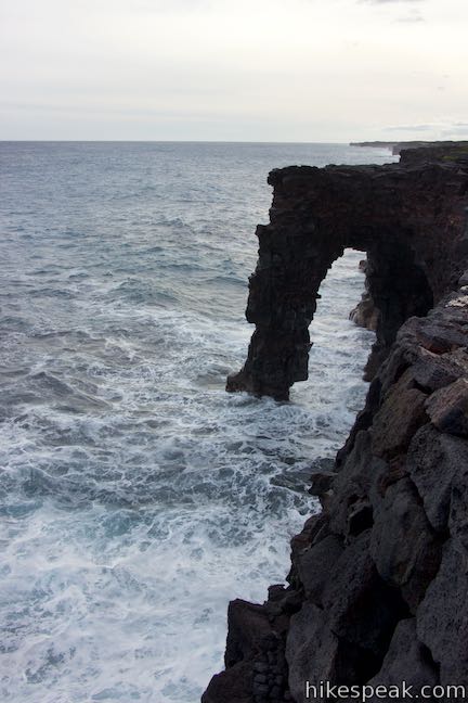
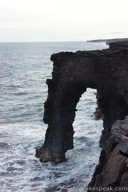
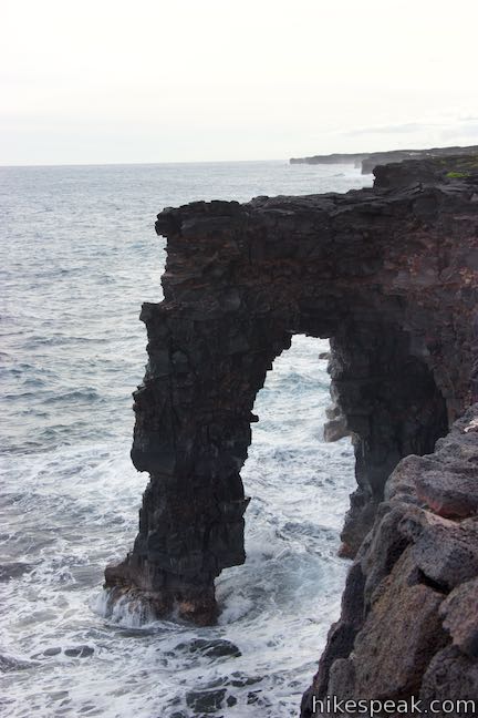
Hōlei Sea Arch
in Hawai‘i Volcanoes National Park
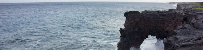
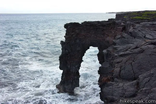
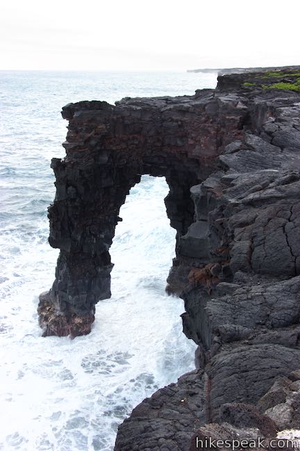
Hawai‘i Volcanoes National Park protects a changing landscape. This is true from the eruptive developments at Kīlauea Caldera all the way down to the ocean erosion at Hōlei Sea Arch. How much longer will this 90-foot tall bridge of basalt withstand the surf? Take a short walk – 100 yards each way – to Hōlei Sea Arch and see it while you can!
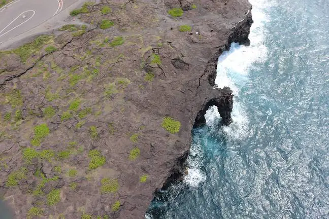
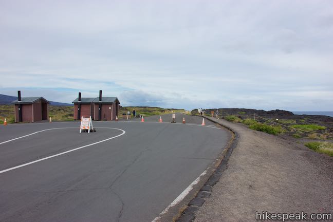
Hōlei Sea Arch is 22 scenic miles from Kīlauea Visitor Center at the bottom of Chain of Craters Road. From the end of the portion of the road that can be driven (eruptions from Kīlauea volcano have closed the rest of the road), it is a short walk to an overlook by Hōlei Sea Arch.
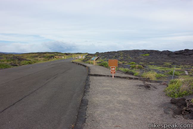
Leave the turnaround at road’s end (by the bathrooms) and walk a few paces up the continuation of the road, which is open to hikers and cyclists. Arrive immediately at the start of the trail down to Hōlei Sea Arch Overlook. Turn right onto the trail.
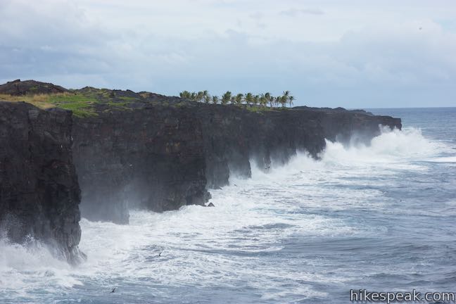
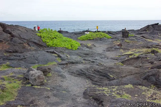
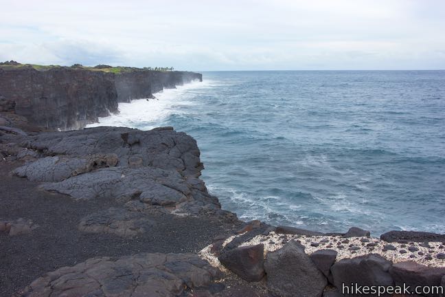
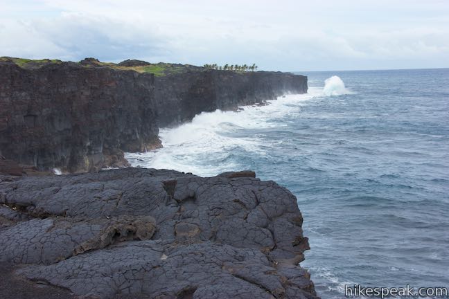
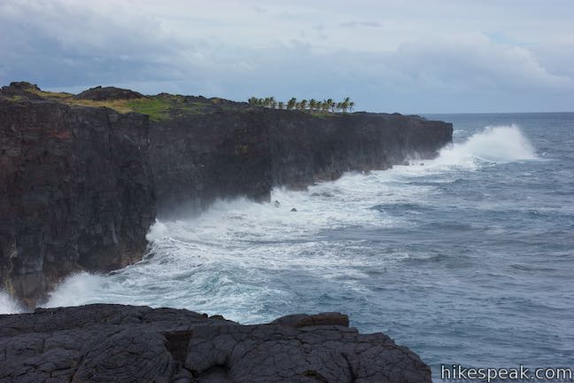
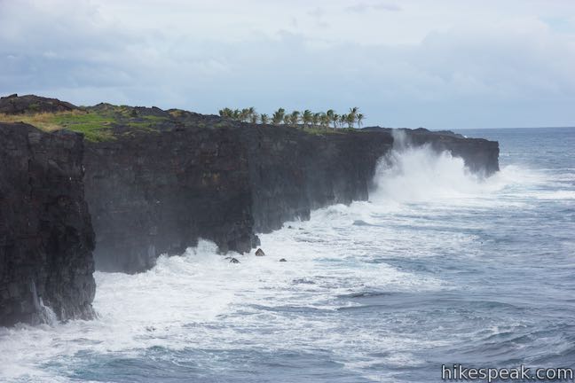
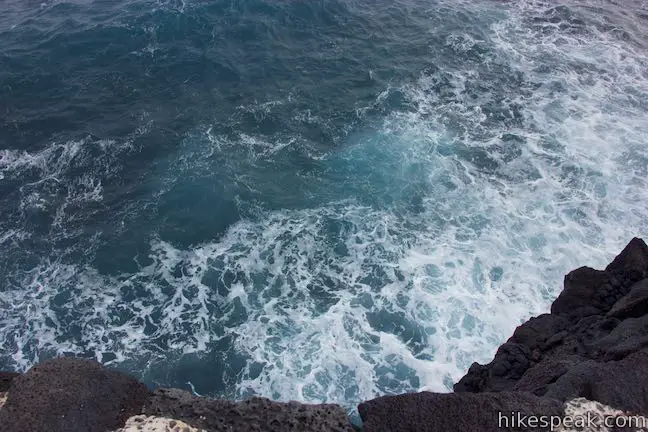
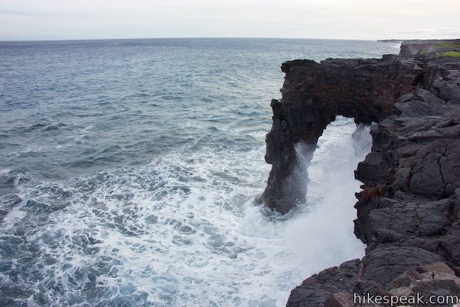
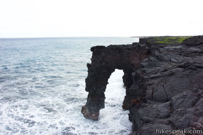
The short trail heads toward the edge of sea cliffs east of the sea arch. Trail’s end also boasts a fine perspective up the shoreline to the east, where punchy waves collide with the black wall of basalt sea cliffs.
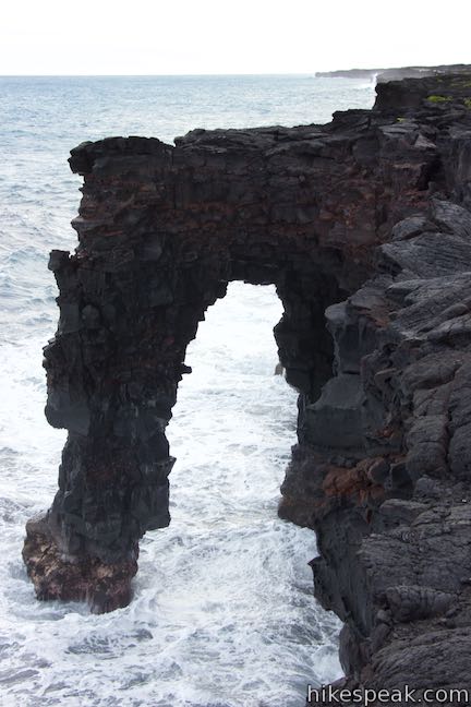
Look west to see Hōlei Sea Arch, a short distance away. The arch extends from the sea cliffs into the ocean like an elephant’s trunk. Hōlei Sea Arch is a natural bridge made of basalt. The lava for Hōlei Sea Arch came from an eruption of Kāne Nui O Hamo, a shield volcano to the northwest. Since the eruption, around 600 years ago, marine erosion provided by the ocean’s waves has slowly carved out the sea arch.
How do waves create an arch? When some layers of lava are softer than others, the soft spots erode faster than the harder rock. Sometimes this differential erosion generates inspired shapes, like the natural bridge at Hōlei Sea Arch.
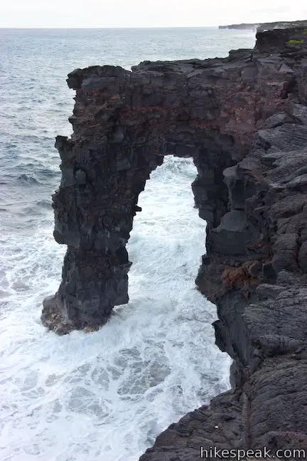
Hōlei Sea Arch is one of the park’s youngest features, having been created in the last 100 years. Unfortunately, it may also be one of the soonest to disappear. The battering waves never cease washing up the arch. How long can Hōlei Sea Arch withstand the abuse?
Waves aren’t the only threat to Hōlei Sea Arch. A 2018 facebook post from Hawaii Volcanoes National Park suggests that the arch may be standing on borrowed time. “As seen in the picture, a new substantial crack is located where the arch meets the cliff. It was sustained from all of the recent earthquake activity happening on the volcano.”
When Hōlei Sea Arch finally does fall, it should give visitors the opportunity to observe other phases of the geological development of the coastine, becoming a sea stack or a sea cave as the basalt cliffs retreats inland.
Take in views of the 90-foot tall Hōlei Sea Arch (while it stands) and then return to Chain of Craters Road for a 0.1-mile round trip hike with 15 feet of elevation change. A panel by the start of the trail explains that you are close to the start of the Hawaiian Islands:
Just offshore, magma pushes through the ocean floor and new volcanoes come to life. Fueled by a hot spot, colossal volcanoes gradually build from the ocean’s dark depths. At the horizon, about 28 miles (45 kilometers) in the distance, lies the submerged summit of the newest volcano – Lō‘ihi (also know as Kama‘ehu in Hawaiian chants). At 3,180 feet (969 m) below sea level, the sun’s rays never reach its summit. These young volcanoes emerge to form the next new islands.
Hōlei Sea Arch is just a small bridge in one of the world’s longest chains of islands stretching from Lō‘ihi and the Big Island past Kaua‘i to Kure Atoll, over 1,600 miles across the Pacific Ocean. As the plates shift and volcanic islands move farther from the hotspot, they grow dormant and, with the passing of enough time, erode back into the ocean. So it goes.
Hōlei Sea Arch Trail is open to hikers, but closed to pets, bikes, and horses. No permit is required for this hike, but an entrance fee is charged to visit Hawai‘i Volcanoes National Park.
- Don’t miss nearby Pu‘u Loa Petroglyphs Trail, 2.5 miles up Chain of Craters Road
Directions to the Trailhead
- Take Hawaii Belt Road (Route 11) to the entrance of Hawaii Volcanoes National Park (which is 30 miles south of Hilo).
- The park entrance is on the left when traveling from Hilo.
- Drive past an entrance station to the first intersection.
- (Kīlauea Visitor Center is just to the right.)
- Turn left and drive 3 miles down Crater Rim Drive to an intersection with Chain of Craters Road and the Devastation Trail Parking Area.
- Turn left onto Chain of Craters Road and drive another 18.5 miles down to the Hōlei Sea Arch Trailhead at road's end.
Trailhead Location
Trailhead address: Chain of Craters Road, Hawaii Volcanoes National Park, HI 96778
Trailhead coordinates: 19.29515, -155.0983 (19° 17′ 42.5″N 155° 05′ 53.9″W)
View Hawai‘i Volcanoes National Park in a larger map
Or view a regional map of surrounding Hawaii trails and campgrounds.


 | Pu‘u Loa Petroglyphs Trail This 1.4-mile hike in Hawai‘i Volcanoes National Park traverses an old lava flow to a boardwalk loop within a special area of preserved petroglyphs. |
 | Keanakāko‘i Crater & Overlook Trail This 2.15-mile hike follows eruption-damaged Crater Rim Drive to views into Keanakako'i Crater and the far grander Kilauea Summit. |
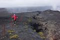
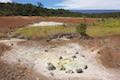 | Sulphur Banks Trail - Crater Rim Trail Loop This 1.6-mile hike starting from Kīlauea Visitor Center tours a colorful hydrothermal area and looks into Kīlauea Caldera from Steaming Bluff. |
 | Kīpukapuaulu Trail This 1.2-mile nature trail loop visits a forest oasis within the lava flows below Mauna Loa in Hawaii Volcanoes National Park. |
 | Rainbow Falls This 0.2-mile hike around Rainbow Falls Lookout explores a viewpoint facing a lovely waterfall and also ventures up to the top of the falls. |
 | Kaumana Caves This underground hike explores lava tubes on the edge of Hilo, created by an 1881 eruption of Mauna Loa. |
 | ‘Akaka Falls This short loop slips through a tropical valley to bold views of a 442-foot single-drop waterfall. |
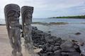 | Royal Grounds – Pu‘uhonua Loop This half-mile loop on the coast south of Kona explores Hawaiian royal grounds and a place of sanctuary in Pu‘uhonua O Hōnaunau National Historical Park. |
 | Trails in Hawaii Explore more hikes on the Big Island of Hawai‘i. |
- A facebook post from Hawaii Volcanoes National Park about a crack forming behind Hōlei Sea Arch (opens in a new tab)
- Hōlei Sea Arch on wikipedia.org (opens in a new tab)
- Hōlei Sea Arch and the end of Chain of Craters Road on bigislandhikes.com (opens in a new tab)
- The official Hawaii National Parks webpage for Hōlei Sea Arch (opens in a new tab)
Common Questions about Hōlei Sea Arch in Hawai‘i Volcanoes National Park
- Is the trail open?
- Yes. You should expect to find that Sea Arch Trail is open. There are no recent reports of trail closures. If you discover that the trail is closed, please help your fellow hikers by reporting a closure.
- Do I need a permit for this hike?
- Yes. National Park Entrance Fee.
- How long is this hike?
- The hike to Sea Arch Trail is a 0.1 mile out and back with 15 feet of elevation change.
- Are dogs allowed on this trail?
- No, dogs are likely not allowed on Sea Arch Trail. The trail is primarily open to hikers.
- Is Sea Arch Trail good for kids?
- Yes, this hike is likely suitable for children. It is relatively short (0.1 miles) with manageable elevation gain.
- Are there ocean views on this hike?
- Yes, Sea Arch Trail offers views of the ocean.
- Where is the trailhead located?
- The trailhead for Sea Arch Trail is located in Hawaii Volcanoes National Park, Hawaii.
Trailhead Address:
Chain of Craters Road
Hawaii Volcanoes National Park, Hawaii 96778
Trailhead Coordinates:
19.29515, -155.0983 - What are the driving directions to the start of the hike?
To get to the trailhead: Take Hawaii Belt Road (Route 11) to the entrance of Hawaii Volcanoes National Park (which is 30 miles south of Hilo). The park entrance is on the left when traveling from Hilo. Drive past an entrance station to the first intersection. (Kīlauea Visitor Center is just to the right.) Turn left and drive 3 miles down Crater Rim Drive to an intersection with Chain of Craters Road and the Devastation Trail Parking Area. Turn left onto Chain of Craters Road and drive another 18.5 miles down to the Hōlei Sea Arch Trailhead at road's end.
View custom Google Maps directions from your current location.
- Are there other trails near Sea Arch Trail?
- Yes, you can find other nearby hikes using the Hikespeak Hike Finder Map.

Go the extra miles...
Submit a rating of this hike to go with your comment. Contribute to the average trail rating.