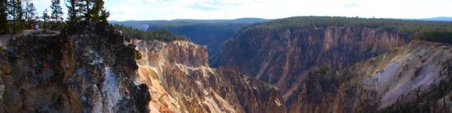
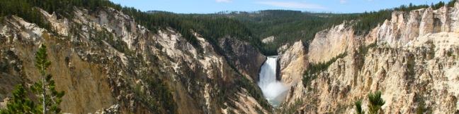
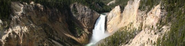
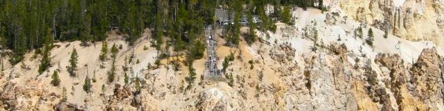
Point Sublime Trail South Rim Hike Grand Canyon of the Yellowstone River in Yellowstone National Park
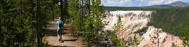
The people in charge of naming landmarks at Yellowstone National Park didn't hold back when they assigned the name Point Sublime to a viewpoint on the south rim of the Grand Canyon of the Yellowstone River. The trail to Point Sublime offers views that can't be seen from a car, exploring the picturesque canyon wall beyond Artist Point. It is 3 miles round trip to Point Sublime with a gradual 250 feet of elevation gain. ...Read more.
My Hikes: Completed hikeA green icon of shows a picture of a landscape with a check mark in the upper right corner, signifying that this is a hike you would like to put on your completed list.OK! Add to trails I've hiked
My Hikes: Want to hikeA green icon of shows a picture of a landscape with a heart in the upper right corner, signifying that this is a hike you would like to put on your to-do list.OK! Add to trails I want to hike
TagsA green icon depicting a tags represents a list of words and phrases that this content is tagged with Tagged with · Grand Canyon of the Yellowstone · National Parks
Hike DistanceA green icon of a hiker used to label information about the length of the hike Distance: 3 miles · Elevation change: 250 feet
By: Published: Last updated: April 23, 2017
North Rim Trail Grand Canyon of the Yellowstone River in Yellowstone National Park
No trip to Yellowstone National Park is complete without a visit to the Grand Canyon of the Yellowstone River, a deep chasm with two fetching waterfalls. You can get numerous memorable views of the canyon by hiking along North Rim Trail, which stretches 3.8 miles over a paved and unpaved path crossing the northwest wall of the Grand Canyon of the Yellowstone River (with just 250 feet of elevation change). ...Read more.
My Hikes: Completed hikeA green icon of shows a picture of a landscape with a check mark in the upper right corner, signifying that this is a hike you would like to put on your completed list.OK! Add to trails I've hiked
My Hikes: Want to hikeA green icon of shows a picture of a landscape with a heart in the upper right corner, signifying that this is a hike you would like to put on your to-do list.OK! Add to trails I want to hike
TagsA green icon depicting a tags represents a list of words and phrases that this content is tagged with Tagged with · Grand Canyon of the Yellowstone · National Parks · Waterfalls
Hike DistanceA green icon of a hiker used to label information about the length of the hike Distance: 7.6 miles · Elevation change: 250 feet
By: Published: Last updated: January 9, 2018
Artist Point viewpoint Grand Canyon of the Yellowstone River in Yellowstone National Park
Artist Point is one of the marquee overlooks on the Grand Canyon of the Yellowstone River, with an exceptional perspective of canyon's most famous feature, the 308-foot Lower Falls. The viewpoint juts out from the south wall of the canyon and is just a short 0.1-mile walk from South Rim Drive. Beyond the paved trail, you can continue hiking along the south rim of the canyon to places like Point Sublime. ...Read more.
My Hikes: Completed hikeA green icon of shows a picture of a landscape with a check mark in the upper right corner, signifying that this is a hike you would like to put on your completed list.OK! Add to trails I've hiked
My Hikes: Want to hikeA green icon of shows a picture of a landscape with a heart in the upper right corner, signifying that this is a hike you would like to put on your to-do list.OK! Add to trails I want to hike
TagsA green icon depicting a tags represents a list of words and phrases that this content is tagged with Tagged with · Grand Canyon of the Yellowstone · National Parks · Waterfalls
Hike DistanceA green icon of a hiker used to label information about the length of the hike Distance: 0.2 miles · Elevation change: 50 feet
By: Published: Last updated: January 8, 2019
Brink of the Upper Falls Trail Grand Canyon of the Yellowstone River in Yellowstone National Park
The Grand Canyon of the Yellowstone River begins at Upper Falls, cutting a 20-mile long, 1,000-foot deep gash across Yellowstone National Park. Walk right up to the edge of the dramatic tumbler on Brink of the Upper Falls Trail and stare down the thundering 109-foot waterfall. You can visit the Brink of the Upper Falls as a spur off North Rim Trail or as a short standalone hike from a parking area just uphill from the waterfall. ...Read more.
My Hikes: Completed hikeA green icon of shows a picture of a landscape with a check mark in the upper right corner, signifying that this is a hike you would like to put on your completed list.OK! Add to trails I've hiked
My Hikes: Want to hikeA green icon of shows a picture of a landscape with a heart in the upper right corner, signifying that this is a hike you would like to put on your to-do list.OK! Add to trails I want to hike
TagsA green icon depicting a tags represents a list of words and phrases that this content is tagged with Tagged with · Grand Canyon of the Yellowstone · National Parks · Waterfalls
Hike DistanceA green icon of a hiker used to label information about the length of the hike Distance: 0.4 miles · Elevation change: 75 feet
By: Published: Last updated: April 23, 2017
Lookout Point Lower Falls North Rim Grand Canyon of the Yellowstone River in Yellowstone National Park
Lookout Point, like Inspiration Point, is a panoramic overlook on the north rim of the Grand Canyon of the Yellowstone River. Lookout Point offers a stunning view of the 308-foot Lower Falls tier of Yellowstone Falls. Similar to Inspiration Point, you may drive right up to Lookout Point or visit the overlook as a stop on North Rim Trail. The minimum distance to Lookout Point is 0. ...Read more.
My Hikes: Completed hikeA green icon of shows a picture of a landscape with a check mark in the upper right corner, signifying that this is a hike you would like to put on your completed list.OK! Add to trails I've hiked
My Hikes: Want to hikeA green icon of shows a picture of a landscape with a heart in the upper right corner, signifying that this is a hike you would like to put on your to-do list.OK! Add to trails I want to hike
TagsA green icon depicting a tags represents a list of words and phrases that this content is tagged with Tagged with · Grand Canyon of the Yellowstone · National Parks · Waterfalls
Hike DistanceA green icon of a hiker used to label information about the length of the hike Distance: 0.15 miles · Elevation change: 25 feet
By: Published: Last updated: April 19, 2018
Inspiration Point viewpoint North Rim Overlook Grand Canyon of the Yellowstone River in Yellowstone National Park
Starting with the Upper Falls of Yellowstone Falls, The Grand Canyon of the Yellowstone River runs northeast for over 20 miles, carving a 1,000-foot deep gash in the pine-covered landscape. The north and south rims are separated by a mere 3/4 of a mile, with treacherously steep canyon walls painted in oranges, yellows and reds. While you can only see a sliver of Yellowstone Falls from Inspiration Point, there is plenty to get inspired about. ...Read more.
My Hikes: Completed hikeA green icon of shows a picture of a landscape with a check mark in the upper right corner, signifying that this is a hike you would like to put on your completed list.OK! Add to trails I've hiked
My Hikes: Want to hikeA green icon of shows a picture of a landscape with a heart in the upper right corner, signifying that this is a hike you would like to put on your to-do list.OK! Add to trails I want to hike
TagsA green icon depicting a tags represents a list of words and phrases that this content is tagged with Tagged with · Grand Canyon of the Yellowstone · National Parks
Hike DistanceA green icon of a hiker used to label information about the length of the hike Distance: 0.1 miles · Elevation change: 50 feet
By: Published: Last updated: April 19, 2018
Porcelain Basin Trail Norris Geyser Basin in Yellowstone National Park
Norris Geyser Basin is one of Yellowstone's prime hydrothermal areas, found on the west side of the park, several miles north of Old Faithful. Norris Geyser Basin is split into two areas, Porcelain Basin and the Back Basin. Each area has its own set of trails. The Porcelain Basin side of Norris Geyser Basin can be explored on two easy boardwalk loops. ...Read more.
My Hikes: Completed hikeA green icon of shows a picture of a landscape with a check mark in the upper right corner, signifying that this is a hike you would like to put on your completed list.OK! Add to trails I've hiked
My Hikes: Want to hikeA green icon of shows a picture of a landscape with a heart in the upper right corner, signifying that this is a hike you would like to put on your to-do list.OK! Add to trails I want to hike
TagsA green icon depicting a tags represents a list of words and phrases that this content is tagged with Tagged with · Geyser Basins · Hydrothermal · National Parks
Hike DistanceA green icon of a hiker used to label information about the length of the hike Distance: 1.1 miles · Elevation change: 100 feet
By: Published: Last updated: January 9, 2018
Back Basin Trail Steamboat Geyser Norris Geyser Basin in Yellowstone National Park
Norris Geyser Basin is home to Steamboat Geyser, the tallest geyser in the world, found on Back Basin Trail. You'll have to get quite lucky to see Steamboat at full strength, as the geyser can go 50 years between major eruptions. Back Basin Trail is a 1.75-mile loop passing numerous hot springs and geysers. You can cut that distance in half by exploiting a shortcut just past Steamboat Geyser. ...Read more.
My Hikes: Completed hikeA green icon of shows a picture of a landscape with a check mark in the upper right corner, signifying that this is a hike you would like to put on your completed list.OK! Add to trails I've hiked
My Hikes: Want to hikeA green icon of shows a picture of a landscape with a heart in the upper right corner, signifying that this is a hike you would like to put on your to-do list.OK! Add to trails I want to hike
TagsA green icon depicting a tags represents a list of words and phrases that this content is tagged with Tagged with · Geyser Basins · Hydrothermal · National Parks
Hike DistanceA green icon of a hiker used to label information about the length of the hike Distance: 1.75 miles · Elevation change: 100 feet
By: Published: Last updated: January 10, 2018
Old Faithful Geyser Yellowstone National Park
Sixty-percent of the world's geysers are found in Yellowstone National Park and the most famous of all is Old Faithful Geyser. Like Biscuit Basin, Old Faithful is found in Yellowstone's Upper Geyser Basin, an incredible one square mile area that contains over 150 geysers. Old Faithful Geyser has soaring bursts and is one of Yellowstone's most predictable geysers, erupting about every 90 minutes. ...Read more.
My Hikes: Completed hikeA green icon of shows a picture of a landscape with a check mark in the upper right corner, signifying that this is a hike you would like to put on your completed list.OK! Add to trails I've hiked
My Hikes: Want to hikeA green icon of shows a picture of a landscape with a heart in the upper right corner, signifying that this is a hike you would like to put on your to-do list.OK! Add to trails I want to hike
TagsA green icon depicting a tags represents a list of words and phrases that this content is tagged with Tagged with · Boardwalks · Hydrothermal · National Parks
Hike DistanceA green icon of a hiker used to label information about the length of the hike Distance: 0.5 miles · Elevation change: 25 feet
By: Published: Last updated: May 13, 2025
Fountain Paint Pot area Lower Geyser Basin in Yellowstone National Park, Silex Spring, Red Spouter, Fumeroles, Fountain Geyser, Clepsydra Geyser, Celestine Spring
Yellowstone National Park has several hydrothermal areas, so what makes the Fountain Paint Pot Area worth visiting? For starters, this part of Lower Geyser Basin has all four of the hydrothermal features found in the park (mudpots, geysers, hot springs, and fumaroles) and you can see them all from a compact half-mile long boardwalk loop. While none of the many Fountain Paint Pot Area geysers are as famous as Old Faithful, they erupt so frequently that you are almost guaranteed a great show on your short hike. ...Read more.
My Hikes: Completed hikeA green icon of shows a picture of a landscape with a check mark in the upper right corner, signifying that this is a hike you would like to put on your completed list.OK! Add to trails I've hiked
My Hikes: Want to hikeA green icon of shows a picture of a landscape with a heart in the upper right corner, signifying that this is a hike you would like to put on your to-do list.OK! Add to trails I want to hike
TagsA green icon depicting a tags represents a list of words and phrases that this content is tagged with Tagged with · Geyser Basins · Hydrothermal · National Parks
Hike DistanceA green icon of a hiker used to label information about the length of the hike Distance: 0.5 miles · Elevation change: 50 feet
By: Published: Last updated: January 10, 2018