Rankin Ridge Trail Hike Wind Cave National Park Black Hills South Dakota Rankin Ridge Fire Tower Lookout Tower Hike
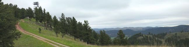
Rankin Ridge forms part of the southeast edge of the Black Hills and at 5,013 feet in elevation, it is the highest point in Wind Cave National Park. A lookout tower rises above the ridge top, which can be reached via a 250-foot ascent on a 0.55-mile long single track. Take a wide dirt trail back down the ridge to form a one-mile loop. Although this hike is short, it is not short on rewards. ...Read more.
My Hikes: Completed hikeA green icon of shows a picture of a landscape with a check mark in the upper right corner, signifying that this is a hike you would like to put on your completed list.OK! Add to trails I've hiked
My Hikes: Want to hikeA green icon of shows a picture of a landscape with a heart in the upper right corner, signifying that this is a hike you would like to put on your to-do list.OK! Add to trails I want to hike
TagsA green icon depicting a tags represents a list of words and phrases that this content is tagged with Tagged with · Black Hills · Custer · Free Trails · Lookout Towers · National Parks · Nature Trails · Summits
Hike DistanceA green icon of a hiker used to label information about the length of the hike Distance: 1 mile · Elevation change: 250 feet
By: Published: Last updated: April 19, 2018
Crazy Horse Memorial Hike Black Hills South Dakota Crazy Horse Volksmarch
It is not every day that you can hike to the top of a 563-foot tall granite carving honoring an American legend. Actually, you can only do this hike a few days a year when the active construction on Crazy Horse Memorial is suspended so that the public can get a close look. The hike passes through forests and fields below the work-in-progress memorial and follows the same road used by construction vehicles up to the arm of the monument where you can walk out and stand below the 8-story tall face of Crazy Horse! ...Read more.
My Hikes: Completed hikeA green icon of shows a picture of a landscape with a check mark in the upper right corner, signifying that this is a hike you would like to put on your completed list.OK! Add to trails I've hiked
My Hikes: Want to hikeA green icon of shows a picture of a landscape with a heart in the upper right corner, signifying that this is a hike you would like to put on your to-do list.OK! Add to trails I want to hike
TagsA green icon depicting a tags represents a list of words and phrases that this content is tagged with Tagged with · Black Hills · Crazy Horse Memorial · Memorials
Hike DistanceA green icon of a hiker used to label information about the length of the hike Distance: 4.75 miles · Elevation change: 775 feet
By: Published: Last updated: July 23, 2025
Binghamton University Nature Preserve hike Ravine Trail Vernal Pool Trail Oak Trail Vestal New York hiking trail
The smart people who shaped Binghamton University knew that deep-rooted oaks can teach us more than ivory towers. With the good foresight, the SUNY Binghamton campus set aside 182 acres of wetlands and woodlands for the benefit of students, faculty, and the community. On a first visit to Binghamton University Nature Preserve, Pond Trail and Marsh Trail are recommended routes for appreciating the heart of the preserve. ...Read more.
My Hikes: Completed hikeA green icon of shows a picture of a landscape with a check mark in the upper right corner, signifying that this is a hike you would like to put on your completed list.OK! Add to trails I've hiked
My Hikes: Want to hikeA green icon of shows a picture of a landscape with a heart in the upper right corner, signifying that this is a hike you would like to put on your to-do list.OK! Add to trails I want to hike
TagsA green icon depicting a tags represents a list of words and phrases that this content is tagged with Tagged with · Binghamton University Nature Preserve · Free Trails · Vestal
Hike DistanceA green icon of a hiker used to label information about the length of the hike Distance: 1.15 miles · Elevation change: 200 feet
By: Published: Last updated: May 13, 2025
Binghamton University Nature Preserve hike Pond Trail Marsh Trail Redwing Trail Loop Vestal New York hiking trail
Some centers of higher learning probably overlook nature's value in education, but not Binghamton University. This SUNY Institution in Vestal, New York set aside 182 acres for the benefit of students, faculty, and the community. Several intersecting trails explore Binghamton University Nature Preserve, creating numerous hiking options, like this one — a figure-eight loop on the easiest and most scenic trails around the wetlands in the middle of the preserve. ...Read more.
My Hikes: Completed hikeA green icon of shows a picture of a landscape with a check mark in the upper right corner, signifying that this is a hike you would like to put on your completed list.OK! Add to trails I've hiked
My Hikes: Want to hikeA green icon of shows a picture of a landscape with a heart in the upper right corner, signifying that this is a hike you would like to put on your to-do list.OK! Add to trails I want to hike
TagsA green icon depicting a tags represents a list of words and phrases that this content is tagged with Tagged with · Binghamton University Nature Preserve · Free Trails · Vestal
Hike DistanceA green icon of a hiker used to label information about the length of the hike Distance: 2.6 miles · Elevation change: 90 feet
By: Published: Last updated: May 13, 2025
Binghamton University Nature Preserve hike Forest Loop Trail Vestal New York hiking trail
We can learn a lot from nature, which is probably why Binghamton University, a SUNY Institution in Vestal, New York had the foresight to preserve a 182-acre natural space right on its campus. Binghamton University Nature Preserve has hillsides and valleys full of forests and marshes with lots of interconnected trails open to the students and the public. ...Read more.
My Hikes: Completed hikeA green icon of shows a picture of a landscape with a check mark in the upper right corner, signifying that this is a hike you would like to put on your completed list.OK! Add to trails I've hiked
My Hikes: Want to hikeA green icon of shows a picture of a landscape with a heart in the upper right corner, signifying that this is a hike you would like to put on your to-do list.OK! Add to trails I want to hike
TagsA green icon depicting a tags represents a list of words and phrases that this content is tagged with Tagged with · Binghamton University Nature Preserve · Free Trails · Vestal
Hike DistanceA green icon of a hiker used to label information about the length of the hike Distance: 1.15 miles · Elevation change: 255 feet
By: Published: Last updated: April 23, 2017
High Line Trail in New York City Manhattan Aerial Greenway The High Line Walk
On the lower west side of Manhattan, an old raised rail line that was headed for demolition has been transformed into an attractive asset, a surprising park that hovers above city streets. The High Line has become a New York City landmark, offering a one-of-a-kind walk with a refreshing perspective of NYC. Like the rest of New York City, the High Line Trail has something for everyone, whether you need a bit of nature, crave art, enjoy bird watching or people watching. ...Read more.
My Hikes: Completed hikeA green icon of shows a picture of a landscape with a check mark in the upper right corner, signifying that this is a hike you would like to put on your completed list.OK! Add to trails I've hiked
My Hikes: Want to hikeA green icon of shows a picture of a landscape with a heart in the upper right corner, signifying that this is a hike you would like to put on your to-do list.OK! Add to trails I want to hike
TagsA green icon depicting a tags represents a list of words and phrases that this content is tagged with Tagged with · Aerial Greenway · Free Trails · High Line · Manhattan · Wheelchair-Friendly
Hike DistanceA green icon of a hiker used to label information about the length of the hike Distance: 3 miles · Elevation change: 40 feet
By: Published: Last updated: July 26, 2025
Spencer Butte Hike Eugene Oregon Ridgeline Trail Spencer Butte Summit
Spencer Butte rises high above the south end of the Willamette Valley near Eugene, Oregon. A 5.2-mile round trip hike to the mountaintop crosses through a lush forest covered in ferns and ascends to a nearly treeless 2,060-foot summit where there are round-the-compass views over Lane County's bucolic valleys and evergreen-covered hills. The woodland walk at the start is pleasant enough to be its own attraction, and the panoramic summit really puts this hike over the top. ...Read more.
My Hikes: Completed hikeA green icon of shows a picture of a landscape with a check mark in the upper right corner, signifying that this is a hike you would like to put on your completed list.OK! Add to trails I've hiked
My Hikes: Want to hikeA green icon of shows a picture of a landscape with a heart in the upper right corner, signifying that this is a hike you would like to put on your to-do list.OK! Add to trails I want to hike
TagsA green icon depicting a tags represents a list of words and phrases that this content is tagged with Tagged with · Buttes · Eugene · Summits
Hike DistanceA green icon of a hiker used to label information about the length of the hike Distance: 5.2 miles · Elevation change: 1100 feet
By: Published: Last updated: June 14, 2021
Latourell Falls Trail Waterfall hike Columbia River Gorge Talbot State Park Oregon Lower Latourell Falls loop trail to Upper Latourell Falls
Latourell Falls is a stunning waterfalls tumbling into the Columbia River Gorge east of Portland. More precisely, there are two waterfalls on Latourell Creek totaling 359 feet of falls. Lower Latourell Falls is a beautiful 225-foot single drop waterfall that can be seen right from the trailhead along Historic Columbia River Highway. Farther up the canyon is Upper Latourell Falls, which is 134 feet tall, sliding down a basalt overhang before twisting to a freefalling plunge. ...Read more.
My Hikes: Completed hikeA green icon of shows a picture of a landscape with a check mark in the upper right corner, signifying that this is a hike you would like to put on your completed list.OK! Add to trails I've hiked
My Hikes: Want to hikeA green icon of shows a picture of a landscape with a heart in the upper right corner, signifying that this is a hike you would like to put on your to-do list.OK! Add to trails I want to hike
TagsA green icon depicting a tags represents a list of words and phrases that this content is tagged with Tagged with · Cascade Range · Free Trails · Guy W. Talbot State Park · Oregon State Parks · Waterfalls
Hike DistanceA green icon of a hiker used to label information about the length of the hike Distance: 2.3 miles · Elevation change: 475 feet
By: Published: Last updated: January 9, 2018
Clark Reservation State Park New York Syracuse hike Cliff Trail Long Trail Mildred Faust Trail
The New York State Park website describes Clark Reservation as 'a geologic wonder of the last ice age and a botanist's paradise.' It's all that and just 5 miles from Syracuse! The star of the park is Glacier Lake, a glacial plunge pool lake surrounded by dramatic limestone cliffs. Over a dozen trails explore this 365-acre park, allowing visitors to put together several different hikes. ...Read more.
My Hikes: Completed hikeA green icon of shows a picture of a landscape with a check mark in the upper right corner, signifying that this is a hike you would like to put on your completed list.OK! Add to trails I've hiked
My Hikes: Want to hikeA green icon of shows a picture of a landscape with a heart in the upper right corner, signifying that this is a hike you would like to put on your to-do list.OK! Add to trails I want to hike
TagsA green icon depicting a tags represents a list of words and phrases that this content is tagged with Tagged with · Clark Reservation State Park · Jamesville · Lakes · New York State Parks · Onondaga County
Hike DistanceA green icon of a hiker used to label information about the length of the hike Distance: 1.95 miles · Elevation change: 150 feet
By: Published: Last updated: September 3, 2025
North County National Scenic Trail hike Hang Glider Launch Site Labrador Hollow Unique Area New York State Forest
For a soaring view over Labrador Hollow Unique Area, a state forest in Central New York, take a hike up Jones Hill to a scenic overlook at a Hang Glider Launch Site. There are two overlapping routes to the launch site from the trailhead for Tinker Falls Trail (a short hike to a lovely waterfall). Onondaga Sky Line Trail is a wide dirt road offering a 1. ...Read more.
My Hikes: Completed hikeA green icon of shows a picture of a landscape with a check mark in the upper right corner, signifying that this is a hike you would like to put on your completed list.OK! Add to trails I've hiked
My Hikes: Want to hikeA green icon of shows a picture of a landscape with a heart in the upper right corner, signifying that this is a hike you would like to put on your to-do list.OK! Add to trails I want to hike
TagsA green icon depicting a tags represents a list of words and phrases that this content is tagged with Tagged with · Cortland County · Labrador Hollow Unique Area · New York State Forests · Onondaga County · Tully
Hike DistanceA green icon of a hiker used to label information about the length of the hike Distance: 2.5 miles · Elevation change: 650 feet
By: Published: Last updated: April 12, 2017