Heaps Peak Arboretum Sequoia Trail San Bernardino Mountains Nature Trail San Bernardino National Forest Arboretum hike Lake Arrowhead California
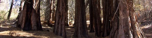
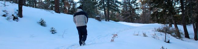
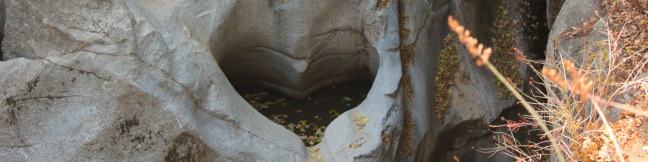
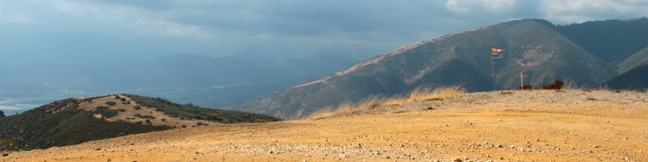
Get to know the plants, animals, and natural history of Southern California at Heaps Peak Arboretum. Located near Lake Arrowhead, the arboretum is a developed piece of San Bernardino National Forest. Sequoia Trail is the main trail through Heaps Peak Arboretum, covering 3/4 of a mile with 90 feet of elevation change. The star of the trail is a planted grove of sequoiadendron giganteum, or what us non-Latin speakers call giant sequoias. ...Read more.
My Hikes: Completed hikeA green icon of shows a picture of a landscape with a check mark in the upper right corner, signifying that this is a hike you would like to put on your completed list.OK! Add to trails I've hiked
My Hikes: Want to hikeA green icon of shows a picture of a landscape with a heart in the upper right corner, signifying that this is a hike you would like to put on your to-do list.OK! Add to trails I want to hike
TagsA green icon depicting a tags represents a list of words and phrases that this content is tagged with Tagged with · Adventure Pass · Arboretums · Lake Arrowhead · Nature Trails · San Bernardino Mountains · San Bernardino National Forest · Skyforest
Hike DistanceA green icon of a hiker used to label information about the length of the hike Distance: 0.75 miles · Elevation change: 90 feet
By: Published: Last updated: September 3, 2025
Towne Trail Big Bear Lake San Bernardino Mountains California hike
If you travel to Big Bear Lake in the San Bernardino Mountains, there's a good chance you like the outdoors. Those looking for a short hike that's quick to access from town should set out on Towne Trail. This 2 2/3-mile round trip hike ascends 200 feet on a gradual rolling course along the base of the mountains on the south side of Big Bear Lake. Discover periodic views north over the lake and the surrounding peaks as you enjoy this pleasant woodland hike between Snow Summit Mountain Resort and Forest Service Road 2N08, just above Knickerbacker Road. ...Read more.
My Hikes: Completed hikeA green icon of shows a picture of a landscape with a check mark in the upper right corner, signifying that this is a hike you would like to put on your completed list.OK! Add to trails I've hiked
My Hikes: Want to hikeA green icon of shows a picture of a landscape with a heart in the upper right corner, signifying that this is a hike you would like to put on your to-do list.OK! Add to trails I want to hike
TagsA green icon depicting a tags represents a list of words and phrases that this content is tagged with Tagged with · Big Bear Lake · Cross Country Skiing · Free Trails · San Bernardino Mountains · San Bernardino National Forest · Snowshoeing
Hike DistanceA green icon of a hiker used to label information about the length of the hike Distance: 2.66 miles · Elevation change: 200 feet
By: Published: Last updated: May 19, 2024
Heart Rock Trail San Bernardino Mountains hike Crestline California Seeley Creek Falls heart shaped rock trail
How is it possible? How is it possible that a perfectly heart-shaped hole could form in the rock wall flanking Seeley Creek Falls? This amazing formation does exist and can be reached via a short, relatively easy one-mile round trip hike in the San Bernardino Mountains near the town of Crestline. The dirt trail to Heart Rock descends 200 feet, following Seeley Creek on a gradual northward descent through a mountain forest of black oaks and Jeffrey pines. ...Read more.
My Hikes: Completed hikeA green icon of shows a picture of a landscape with a check mark in the upper right corner, signifying that this is a hike you would like to put on your completed list.OK! Add to trails I've hiked
My Hikes: Want to hikeA green icon of shows a picture of a landscape with a heart in the upper right corner, signifying that this is a hike you would like to put on your to-do list.OK! Add to trails I want to hike
TagsA green icon depicting a tags represents a list of words and phrases that this content is tagged with Tagged with · Crestline · Free Trails · San Bernardino Mountains · San Bernardino National Forest · Water Slides · Waterfalls
Hike DistanceA green icon of a hiker used to label information about the length of the hike Distance: 1.4 miles · Elevation change: 200 feet
By: Published: Last updated: July 24, 2025
Marshall Peak Trail San Bernardino Mountains summit California
The San Bernardino Mountains are a rugged east-west running mountain range in San Bernardino County east of the San Gabriel Mountains. While the range tops out at the 11,500-foot summit of San Gorgonio Mountain, you can find great panoramic view from a 4,000-foot peak that is much easier to reach. Marshall Peak rises above the foothills of the mighty San Bernardino Mountains and is just a short trip from cities in the San Bernardino Valley. ...Read more.
My Hikes: Completed hikeA green icon of shows a picture of a landscape with a check mark in the upper right corner, signifying that this is a hike you would like to put on your completed list.OK! Add to trails I've hiked
My Hikes: Want to hikeA green icon of shows a picture of a landscape with a heart in the upper right corner, signifying that this is a hike you would like to put on your to-do list.OK! Add to trails I want to hike
TagsA green icon depicting a tags represents a list of words and phrases that this content is tagged with Tagged with · Adventure Pass · Crestline · San Bernardino · San Bernardino Mountains · San Bernardino National Forest · Summits
Hike DistanceA green icon of a hiker used to label information about the length of the hike Distance: 3.25 miles · Elevation change: 375 feet
By: Published: Last updated: July 24, 2025