Kumeyaay Village Site in Anza-Borrego Desert State Park
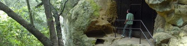
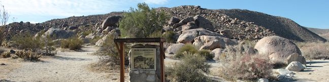
Labeled simply as the Village Site on park maps, the Kumeyaay Village in Anza-Borrego Desert State Park is an easy to visit location where Native Americans lived for thousands of years. Take a short stroll around a pile of boulders along Mine Wash Road and spot grinding holes among the rocks. A sign at the Kumeyaay Village reads: Native desert people have been attracted to the cave of this bouldered hillside for thousands of years. ...Read more.
By: Published: April 20, 2013 Last updated: April 9, 2026
Artist Point on the Grand Canyon of the Yellowstone River in Yellowstone National Park
Artist Point is one of the marquee overlooks on the Grand Canyon of the Yellowstone River, with an exceptional perspective of canyon's most famous feature, the 308-foot Lower Falls. The viewpoint juts out from the south wall of the canyon and is just a short 0.1-mile walk from South Rim Drive. Beyond the paved trail, you can continue hiking along the south rim of the canyon to places like Point Sublime. ...Read more.
Distance: 0.2 miles · Elevation change: 50 feet
By: Published: September 6, 2012 Last updated: April 13, 2026
Lookout Point on the Grand Canyon of the Yellowstone River in Yellowstone National Park
Lookout Point, like Inspiration Point, is a panoramic overlook on the north rim of the Grand Canyon of the Yellowstone River. Lookout Point offers a stunning view of the 308-foot Lower Falls tier of Yellowstone Falls. Similar to Inspiration Point, you may drive right up to Lookout Point or visit the overlook as a stop on North Rim Trail. The minimum distance to Lookout Point is 0. ...Read more.
Distance: 0.15 miles · Elevation change: 25 feet
By: Published: September 4, 2012 Last updated: April 13, 2026
Inspiration Point on the Grand Canyon of the Yellowstone River in Yellowstone National Park
Starting with the Upper Falls of Yellowstone Falls, The Grand Canyon of the Yellowstone River runs northeast for over 20 miles, carving a 1,000-foot deep gash in the pine-covered landscape. The north and south rims are separated by a mere 3/4 of a mile, with treacherously steep canyon walls painted in oranges, yellows and reds. While you can only see a sliver of Yellowstone Falls from Inspiration Point, there is plenty to get inspired about. ...Read more.
Distance: 0.1 miles · Elevation change: 50 feet
By: Published: September 3, 2012 Last updated: April 16, 2026
Old Faithful Geyser in Yellowstone National Park
Sixty-percent of the world's geysers are found in Yellowstone National Park and the most famous of all is Old Faithful Geyser. Like Biscuit Basin, Old Faithful is found in Yellowstone's Upper Geyser Basin, an incredible one square mile area that contains over 150 geysers. Old Faithful Geyser has soaring bursts and is one of Yellowstone's most predictable geysers, erupting about every 90 minutes. ...Read more.
Distance: 0.5 miles · Elevation change: 25 feet
By: Published: August 29, 2012 Last updated: April 17, 2026
Lamar Valley in Yellowstone National Park
No other destination in Yellowstone gives you a greater opportunity to see wild bison than Lamar Valley. The Lamar River feeds a wide grassy valley, drawing the massive grazers to the northeast corner of Yellowstone National Park. Route 212 (Northeast Entrance Road) runs down the valley past numerous viewpoints where you are almost guaranteed a sighting of the Lamar Valley Bison Herd. ...Read more.
By: Published: August 24, 2012 Last updated: April 8, 2026
Calcite Springs Overlook in Yellowstone National Park
When you drive by an overlook in Yellowstone National Park, it pays to stop. A short walk from a turnout on Grand Loop Road just north of Tower Fall brings travelers to Calcite Springs Overlook, perched on a bluff above the narrowest section of the Grand Canyon of Yellowstone. The mesmerizing northward view puts a rugged section of the Yellowstone River on display, accented by bleached cliffs and steam venting hydrothermal springs. ...Read more.
Distance: 0.25 miles · Elevation change: 25 feet
By: Published: August 19, 2012 Last updated: April 13, 2026
Chumash Painted Cave State Historic Park in Santa Barbara
Chumash Painted Cave State Historic Park preserves centuries old Native American artwork that graces the wall of a sandstone cave in the Santa Ynez Mountains behind Santa Barbara. Chumash Painted Cave can be reached by walking a couple hundred feet up a trail on Painted Cave Road. The trailhead is just two miles from California Route 154, making it a quick, convenient, and interesting stop for travelers crossing the 154 between Santa Barbara and the Santa Ynez Valley. ...Read more.
Distance: 0.1 miles · Elevation change: 20 feet
By: Published: July 13, 2012 Last updated: December 5, 2025
Old Zoo Picnic Area in Griffith Park
The old zoo in Griffith Park is one of the strangest ruins in Los Angeles (putting it in the running for strangest ruins worldwide). When the Los Angeles Zoo opened at its current location in the 1960s, the former zoo, a few miles away was not torn down or destroyed. Instead, the zoo was abandoned and converted into a picnic area. Explore one of LA's best off-the-beaten-path attractions on a half mile hike (or more) through the picnic area past old animal cages and exhibits. ...Read more.
Distance: 0.5 miles · Elevation change: 50 feet
By: Published: November 18, 2011 Last updated: April 20, 2026
Glacier Point in Yosemite National Park
Glacier Point is in incredible overlook in Yosemite National Park. The road to Glacier Point closes in the winter and spring because of snow, but maybe the road should be closed year round. Hear me out... The views from Glacier Point are too extraordinary to be able to drive right up to them! It shouldn't be that easy. Imagine how someone would feel after hiking all the way to the top of Half Dome, only to find out that a nearby view over Yosemite Valley requires barely any hiking. ...Read more.
By: Published: May 24, 2011 Last updated: April 13, 2026