Mojave Desert Petroglyphs North Lava Bed Wash 17 mile point Mojave National Preserve California
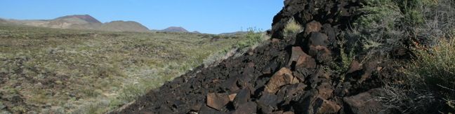
Visitors driving though Mojave National Preserve between Baker and Kelso Depot may wish to stop near Seventeen Mile Point for a quick walk to simple petroglyphs drawn into the volcanic rock outcroppings along the road. While certainly not the only petroglyphs in the preserve, these might be the easiest to get to. A petroglyph engraved into the rock On Kelbaker Road, 13.4 miles from... Read more.
By: Published: Last updated: November 9, 2018
Silver Peak Trail Hike Mojave National Preserve California
This 8.5-mile hike ascends 2,500 feet to summit a 6,365-foot peak in the small range of mountains in the southwestern corner of Mojave National Preserve. Silver Peak looks out across the Granite Mountains toward the Kelso Dunes, Cima Dome, and the peaks of the Providence Range - a worthy view of Mojave National Preserve to be sure. Nearby Granite Peak is the tallest mountain in the range... Read more.
By: Published: Last updated: February 19, 2020
Lava Tube Trail Mojave National Preserve hike California desert cave -- A field of cinder cones stands out dramatically from the surrounding Mojave Desert between the city of Baker and Kelso Depot Visitor Center. Within the lava field is a short trail leading to a tube formed long ago by molten lava. A ladder takes hikers down into the tube where skylights (holes in the rock ceiling) illuminate a subterranean world.
A field of cinder cones stands out dramatically from the surrounding Mojave Desert between the city of Baker and Kelso Depot Visitor Center in Mojave National Preserve. Within the lava field is a short trail leading to a tube formed long ago by molten lava. A ladder takes hikers down into the tube where skylights (holes in the rock ceiling) illuminate a subterranean world. From the... Read more.
By: Published: Last updated: January 1, 2019
Joshua Tree Summit Hike Warren Peak Trail Joshua Tree National Park
Warren Peak is a high point on the western edge of the Little San Bernardino Mountains in Joshua Tree National Park. Located away from Park Boulevard, Warren Peak offers private peace of mind and near endless views. A 5.5-mile round trip hike to the 5,103-foot summit begins from Black Rock Campground, the only campground in the park where visitors can sleep surrounded by Joshua trees. ... Read more.
By: Published: Last updated: June 7, 2017
Lucky Boy Vista Trail Joshua Tree Lucky Boy Vista Hike
Lucky Boy Vista Trail offers a level 2.5-mile round trip hike to a modest overlook at the site of an old mine. The trailhead is a half-mile from the Pine City - Desert Queen Mine Trailhead and easy to find. There are no junctions along the trail to be concerned with. From the parking area, hike southeast across the desert on an easy track that climbs just 125 feet over 1.25 miles. ... Read more.
By: Published: Last updated: January 16, 2020
Inspiration Peak Joshua Tree Hike Keys View Joshua Tree National Park California
With its vast view of Coachella Valley, the Salton Sea, and Mount San Jacinto, Keys View is the principal overlook in Joshua Tree National Park. The excellent vantage more than justifies the 7-mile drive from Park Boulevard, but why stop there? Keys View is also the starting point for a short trek to Inspiration Peak. Leave the crowds behind and visit this 5,550-foot summit, which is just... Read more.
By: Published: Last updated: June 7, 2017
Santa Ynez Falls Santa Ynez Canyon Topanga State Park Pacific Palisades Waterfall Hike Los Angeles
Santa Ynez Falls Trail follows a shaded creek to a gorge containing a short waterfall. This 2.5-mile hike is a popular family outing because it is fairly level (just 250 feet of elevation change) and interesting enough to hold a child's attention for the duration. Santa Ynez Falls is one of the Los Angeles waterfall hikes. The hike begins from a free trailhead into Topanga State... Read more.
By: Published: Last updated: June 11, 2019
Wildflowers Los Angeles Malibu California flowers
Wildflowers in the Santa Monica Mountains, San Gabriel Mountains and other open areas of Los Angeles County bloom each spring adding splashes of color along the area's trails. Some flowers can be seen into the summer and fall. Below are some examples of common wildflowers that appear beside Los Angeles hiking trails. The flowers are listed alphabetically with a link to the trails where they... Read more.
Tagged with · Wildflowers
By: Published: Last updated: January 8, 2019
Lower Canyonback Ridge Trail on Canyonback Ridge in the Santa Monica Mountains in Brentwood, Los Angeles
Lower Canyonback Trail crosses Canyonback Ridge between Brentwood and a development of estate homes built along the ridge. The trail offers views of west Los Angeles, Santa Monica Bay, and neighboring ridges in the Santa Monica Mountains. The Getty Museum to the east is also in view and on the same plane with trail. From the top of Kenter Avenue to Mountain Gate Country Club Estates is 4.2... Read more.
By: Published: Last updated: December 7, 2018
Canyonback Ridge Trail Santa Monica Mountains Brentwood Hike Los Angeles
Canyonback Ridge runs north to south in the area of the Santa Monica Mountains known as the Big Wild. The ridge is located east of Mandeville Canyon near San Vicente Mountain. Much like the neighboring ridges, Westridge, Sullivan Ridge, and Temescal Ridge, there is both a wide fire road and a narrow single-track running along Canyonback Ridge allowing hikers to choose their own adventure on... Read more.
By: Published: Last updated: December 7, 2018