Yaqui Well Trail Anza-Borrego Desert State Park Nature Trail self-guided hike San Felipe Wash Yaqui Well springs Tamarisk Grove Campground hike
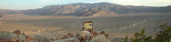
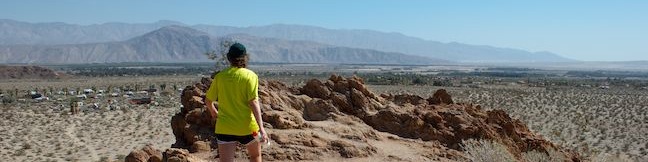
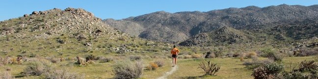
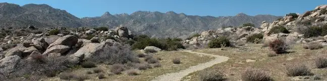
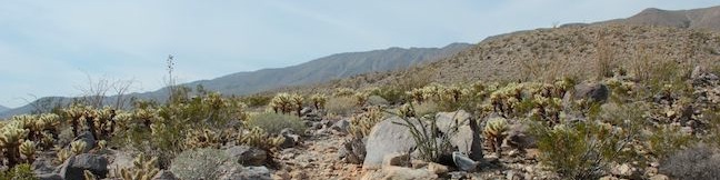
Yaqui Well Trail is one of the free self-guided nature trails in Anza-Borrego Desert State Park. Pair a trail guide (that you can pick up at the trailhead) with numbered markers along the way to learn about the history and botany of Anza-Borrego Desert State Park as you enjoy the surrounding scenery. The 1.6-mile round trip trail with 100 feet of elevation gain ends at Yaqui Well, a vital year-round water source that stands out from its arid desert surrounding. ...Read more.
My Hikes: Completed hikeA green icon of shows a picture of a landscape with a check mark in the upper right corner, signifying that this is a hike you would like to put on your completed list.OK! Add to trails I've hiked
My Hikes: Want to hikeA green icon of shows a picture of a landscape with a heart in the upper right corner, signifying that this is a hike you would like to put on your to-do list.OK! Add to trails I want to hike
TagsA green icon depicting a tags represents a list of words and phrases that this content is tagged with Tagged with · Borrego Springs · California State Parks · Free Trails · Nature Trails
Hike DistanceA green icon of a hiker used to label information about the length of the hike Distance: 1.6 miles · Elevation change: 100 feet
By: Published: Last updated: December 5, 2025
Kenyon Overlook Trail loop viewpoint Yaqui Pass hike Anza-Borrego Desert State Park California Bill Kenyon Trail
Looks can be deceiving. Kenyon Overlook Trail doesn't impress at the start - a dirt single track leaving the most primitive campground in Anza-Borrego Desert State Park. The trail crosses pleasant but generic desert landscape at Yaqui Pass. Stick with this hike because the payoff is massive - a huge view across Mescal Bajada toward Sunset Mountain (which puts on a colorful display from the overlook at sunset). ...Read more.
My Hikes: Completed hikeA green icon of shows a picture of a landscape with a check mark in the upper right corner, signifying that this is a hike you would like to put on your completed list.OK! Add to trails I've hiked
My Hikes: Want to hikeA green icon of shows a picture of a landscape with a heart in the upper right corner, signifying that this is a hike you would like to put on your to-do list.OK! Add to trails I want to hike
TagsA green icon depicting a tags represents a list of words and phrases that this content is tagged with Tagged with · Borrego Springs · California State Parks · Free Trails
Hike DistanceA green icon of a hiker used to label information about the length of the hike Distance: 1.15 miles · Elevation change: 125 feet
By: Published: Last updated: December 5, 2025
Marshal South Home Trail Yaquitepec site Ghost Mountain Blair Valley hike Anza-Borrego Desert State Park California
The Anza-Borrego Desert is a beautiful place to visit, but a tough place to live. The areas inhabitants usually built homes near water, trees, and roads, but not Marshal South, who traded utility for scenery when he built a homestead in the 1930s atop Ghost Mountain (Yaquitepec) near Blair Valley in Anza-Borrego Desert State Park. The trail to the ruins of the South's adobe cabin is 1. ...Read more.
My Hikes: Completed hikeA green icon of shows a picture of a landscape with a check mark in the upper right corner, signifying that this is a hike you would like to put on your completed list.OK! Add to trails I've hiked
My Hikes: Want to hikeA green icon of shows a picture of a landscape with a heart in the upper right corner, signifying that this is a hike you would like to put on your to-do list.OK! Add to trails I want to hike
TagsA green icon depicting a tags represents a list of words and phrases that this content is tagged with Tagged with · California State Parks · Free Trails · Ruins
Hike DistanceA green icon of a hiker used to label information about the length of the hike Distance: 1.3 miles · Elevation change: 450 feet
By: Published: Last updated: December 5, 2025
Panoramic Overlook Trail Borrego Palm Canyon hike Anza-Borrego Desert State Park California
Grab your hiking boots and your camera for this short hike to 360-degree views. Panoramic Overlook Trail is a vista-filled one-mile out and back hike with 275 feet of elevation gain. The brief steep effort is rewarded by sweeping views over Borrego Valley from a ridge flanking Borrego Palm Canyon at the base of San Ysidro Mountains, the towering western boundary of Anza-Borrego Desert State Park. ...Read more.
My Hikes: Completed hikeA green icon of shows a picture of a landscape with a check mark in the upper right corner, signifying that this is a hike you would like to put on your completed list.OK! Add to trails I've hiked
My Hikes: Want to hikeA green icon of shows a picture of a landscape with a heart in the upper right corner, signifying that this is a hike you would like to put on your to-do list.OK! Add to trails I want to hike
TagsA green icon depicting a tags represents a list of words and phrases that this content is tagged with Tagged with · Borrego Springs · California State Parks · San Ysidro Mountains
Hike DistanceA green icon of a hiker used to label information about the length of the hike Distance: 1 mile · Elevation change: 275 feet
By: Published: Last updated: December 5, 2025
Tubb Canyon Trail to Big Spring in Anza-Borrego Desert State Park hike
Driving around Anza-Borrego Desert State Park, you will pass quite a few unnamed or unmarked footpaths heading off somewhere into the desert. If you are curious enough to venture down one of these mysterious trails, make your way to Tubb Canyon. Located near Culp Valley Primitive Campground in the San Ysidro Mountains on the west side of the park, Tubb Canyon Trail offers an easy 1. ...Read more.
My Hikes: Completed hikeA green icon of shows a picture of a landscape with a check mark in the upper right corner, signifying that this is a hike you would like to put on your completed list.OK! Add to trails I've hiked
My Hikes: Want to hikeA green icon of shows a picture of a landscape with a heart in the upper right corner, signifying that this is a hike you would like to put on your to-do list.OK! Add to trails I want to hike
TagsA green icon depicting a tags represents a list of words and phrases that this content is tagged with Tagged with · California State Parks · Free Trails · San Ysidro Mountains
Hike DistanceA green icon of a hiker used to label information about the length of the hike Distance: 1.5 miles · Elevation change: 200 feet
By: Published: Last updated: December 5, 2025
Culp Valley Loop Culp Valley Primitive Campground hike Culp Valley Trail to Culp Valley Overlook California Riding and Hiking Trail to Peña Springs in the San Ysidro Mountains in Anza-Borrego Desert State Park
If you like mountain views without a mountainous amount of effort, set out on Culp Valley Loop. This 2.2-mile hike with 200 feet of elevation change begins from Culp Valley Primitive Campground in the San Ysidro Mountains west of Borrego Springs. The campground is just off Montezuma Highway, the main road into the park from the west, making Culp Valley Loop a convenient first stop for Anza-Borrego Desert State Park visitors coming from Los Angeles, San Diego, or somewhere in between. ...Read more.
My Hikes: Completed hikeA green icon of shows a picture of a landscape with a check mark in the upper right corner, signifying that this is a hike you would like to put on your completed list.OK! Add to trails I've hiked
My Hikes: Want to hikeA green icon of shows a picture of a landscape with a heart in the upper right corner, signifying that this is a hike you would like to put on your to-do list.OK! Add to trails I want to hike
TagsA green icon depicting a tags represents a list of words and phrases that this content is tagged with Tagged with · California State Parks · Free Trails · San Ysidro Mountains · Wheelchair-Friendly
Hike DistanceA green icon of a hiker used to label information about the length of the hike Distance: 2.2 miles · Elevation change: 200 feet
By: Published: Last updated: December 5, 2025
Culp Valley Campground Anza-Borrego Desert State Park Culp Valley Primitive Camping California Desert
Culp Valley is a primitive campground in the San Ysidro Mountains west of Borrego Springs. At 3,375 feet above sea level, the campground a cradled by peaks. Here's what Culp Valley Primitive Campground doesn't have: water, picnics tables, fire rings, and charcoal grills. Here is what the campground does have: vault toilets and ground to put a tent on. ...Read more.
TagsA green icon depicting a tags represents a list of words and phrases that this content is tagged with Tagged with · California State Parks · Primitive Camping · San Ysidro Mountains · Tent Camping
By: Published: Last updated: October 8, 2024
Malibu Springs Trail to Nicholas Flat Malibu California hike Santa Monica Mountains Leo Carrillo State Park Mulholland Highway hike to Nicholas Flat Natural Preserve
Near the west end of Mulholland Highway north of Leo Carrillo State Park, you will find an almost hidden trailhead for Malibu Springs Trail. This spring-loaded single track is faint and overgrown in areas, providing a sense of adventure as you take in fantastic views of the highest peaks Santa Monica Mountains. At the end of an arduous climb, you will drop down to Nicholas Flat in Nicholas Flat Natural Preserve. ...Read more.
My Hikes: Completed hikeA green icon of shows a picture of a landscape with a check mark in the upper right corner, signifying that this is a hike you would like to put on your completed list.OK! Add to trails I've hiked
My Hikes: Want to hikeA green icon of shows a picture of a landscape with a heart in the upper right corner, signifying that this is a hike you would like to put on your to-do list.OK! Add to trails I want to hike
TagsA green icon depicting a tags represents a list of words and phrases that this content is tagged with Tagged with · California State Parks · Free Trails · Leo Carrillo State Park · Malibu · Nicholas Flat Natural Preserve · Ocean Views · Wildflowers · Santa Monica Mountains
Hike DistanceA green icon of a hiker used to label information about the length of the hike Distance: 7 miles · Elevation change: 1425 feet
By: Published: Last updated: December 5, 2025
Mesa Peak hike Backbone Trail Piuma Trailhead Malibu Creek State Park hike Tapia Park ocean view summit Malibu California
A mesa is defined as a flat-topped hill with steep sides. A peak is defined as the pointed top of a mountain. Put these contradictions together and you get a subtle summit with substantial ocean views. This short perch on a mesa-like ridge behind Pepperdine University in Malibu delivers panoramic views over the surrounding Santa Monica Mountains. The hike to Mesa Peak up the steep sides of the mesa begins from the Piuma Trailhead in Malibu Creek State Park and follows 2. ...Read more.
My Hikes: Completed hikeA green icon of shows a picture of a landscape with a check mark in the upper right corner, signifying that this is a hike you would like to put on your completed list.OK! Add to trails I've hiked
My Hikes: Want to hikeA green icon of shows a picture of a landscape with a heart in the upper right corner, signifying that this is a hike you would like to put on your to-do list.OK! Add to trails I want to hike
TagsA green icon depicting a tags represents a list of words and phrases that this content is tagged with Tagged with · Backbone Trail · California State Parks · Malibu · Ocean Views · Summits · Malibu Creek State Park · Santa Monica Mountains
Hike DistanceA green icon of a hiker used to label information about the length of the hike Distance: 6.5 miles · Elevation change: 1375 feet
By: Published: Last updated: December 9, 2025
Moonstone Beach Boardwalk in Cambria San Luis Obispo County California Big Sur Coast beach hike stroll walk central coast
The city of Cambria is located on Highway One at the north end of San Luis Obispo County, and has earned the nickname "Gateway to the Big Sur Coast." Like that stunning area to the north, Cambria has its own beautiful waterfront. Explore sandy beaches and rocky tide pools on a 2.85-mile round trip hike down Moonstone Beach Boardwalk, crossing a pristine beach that is preserved by Hearst San Simeon State Park. ...Read more.
My Hikes: Completed hikeA green icon of shows a picture of a landscape with a check mark in the upper right corner, signifying that this is a hike you would like to put on your completed list.OK! Add to trails I've hiked
My Hikes: Want to hikeA green icon of shows a picture of a landscape with a heart in the upper right corner, signifying that this is a hike you would like to put on your to-do list.OK! Add to trails I want to hike
TagsA green icon depicting a tags represents a list of words and phrases that this content is tagged with Tagged with · Big Sur · Boardwalks · California State Parks · Cambria · Free Trails · Hearst San Simeon State Park · Ocean Views · Tide Pools · Wheelchair-Friendly
Hike DistanceA green icon of a hiker used to label information about the length of the hike Distance: 2.85 miles · Elevation change: 40 feet
By: Published: Last updated: December 5, 2025

Tag!

You've come to a tag page, one of the blogiest ways to browse hikespeak.com.

Here are some more tags. The most common tags are the big ones at the top of the list. Have a look around. You may also find what you seek with the search feature on the Hike Finder Map.

Free TrailsNational ParksOcean ViewsCalifornia State ParksSummitsWaterfallsTent CampingCreeksLakesNature TrailsAngeles National ForestMalibuAdventure PassCascade RangeNew Zealand Department of ConservationDesert CanyonsOff TrailWildflowersBeachesLos Padres National ForestNew Zealand National ParksMountains Recreation and Conservation AuthoritySan Gabriel Mountains National MonumentGriffith ParkBig SurWheelchair-FriendlyCampervan CampingRuinsSequoia GrovesOregon State ParksLos OsosPacific Crest TrailHydrothermalCavesHollywoodBackpackingMontaña de Oro State ParkAustralian National ParksTopanga State ParkYosemite ValleyRedwood GrovesAltadenaSanta Ynez MountainsSanta Monica Mountains National Recreation AreaTopangaIrish HillsLone PineMalibu Creek State ParkBorrego SpringsAgoura HillsTrail CampArchesBureau of Land ManagementLookout TowersPacific PalisadesBoulderingDeschutes National ForestColumbia River Gorge National Scenic AreaBackbone TrailLavaWest Hills of PortlandMorrosTualatin MountainsArthur's Pass VillageMinesNevada State ParksTongariro National ParkMammoth LakesWalk-in CampingFruitaGrand JunctionArthur's Pass National ParkBendGiant ForestLa Cañada FlintridgeTide PoolsMorro BayCleveland National ForestRotoruaAzusaJohn Muir TrailAccommodationsOvertonArcadiaPasadenaZion CanyonLava TubesGoletaIsland in the SkyCalabasasTasmania's 60 Great Short WalksHot SpringsSanta Lucia MountainsClaremontGaviota State ParkBadlandsVerdugo MountainsBoardwalksGolden Trout WildernessClosedTillamookPhillip IslandAoraki Mount Cook National ParkRainforestsShasta-Trinity National ForestClosed SeasonallyVolcanoesNorthwest PortlandLas VegasSan Bernardino National ForestGrand Canyon of the YellowstoneForest ParkMount CookVolcanoNewbury ParkPetroglyphsGrant GroveGeyser BasinsStairsButtesBrentwoodGifford Pinchot National ForestFreycinet PeninsulaSan Ysidro MountainsColes BayMorro Bay State ParkTopatopa MountainsThousand OaksPalos Verdes PeninsulaSand DunesOakhurstOnondaga CountyAdirondack ParkAdirondack MountainsMorterosGiant Sequoia National MonumentAnsel Adams WildernessOhakuneOjaiMemorialsFreycinet National ParkLighthousesJohn Muir WildernessTasman PeninsulaTrabuco Ranger DistrictSan Bernardino MountainsWestern DivideSanta Ana MountainsSilver Moccasin TrailOrange County ParksPoint Mugu State ParkWestridge-Canyonback Wilderness ParkPaicinesSunriverWestern Divide Ranger DistrictNatural BridgesWill Rogers State ParkCratersNelder GroveTopanga CanyonStevensonWhakapapa VillageLava Butte Lava FlowWashington State ParksMount Hood National ForestCastle Crags State ParkMount ShastaThree Capes Scenic RouteNewberry National Volcanic MonumentWater SlidesMount HoodTarzanaContinental DivideSouth Lake TahoeSistersHobartReservoir Canyon Natural ReserveDomesPfeiffer Big Sur State ParkHumboldt Redwoods State ParkSouthwest PortlandOasesLeo Carrillo State ParkMoabGovernment CampNewhallLaguna BeachJulianSouth Coast WildernessTemescal Gateway ParkSilver Falls State ParkCambriaHutsSublimityGlacier LakesCliff JumpingGoing-to-the-Sun RoadPearblossomMontecitoHawaii State ParksKlamath MountainsSpringvilleRancho Palos VerdesWawonaDeschutes RiverCamp ShermanWildlife ViewingBeacon Rock State ParkLos Robles Open SpaceTanksYellowstone RiverSan Vicente Mountain ParkSwimming HolesObservatoriesIdyllwildSan Jacinto Ranger DistrictWaiotapuBurbankPalomar Ranger DistrictCalifornia Coastal TrailTasman National ParkLabrador Hollow Unique AreaCortland CountyTullyNew York State ForestsMount William National ParkVestalPicnic AreaWind CavesSan Jacinto MountainsSilver Peak WildernessBinghamton University Nature PreserveCedar GroveBlack HillsAvila BeachJulia Pfeiffer Burns State ParkCinder ConesLake ElsinoreMurrietaWenatche National ForestElephant SealsGlendaleSnowshoeingSan Mateo Canyon WildernessWilsons Promontory National ParkCrestlineEmma Wood State BeachWhananaki NorthCarpinteriaPlacerita Canyon Natural AreaPlacerita Canyon State ParkBike TrailSan PedroTujungaSanta Susana MountainsNew York State ParksSun ValleyCrescent CityRedwood Mountain GroveBishop Peak Natural ReserveAvila ValleySimi HillsSheep Mountain WildernessCrystal Cove State ParkSierra Pelona MountainsSanta MargaritaBeverly HillsConejo ValleyBlue Mountain LakeNicholas Flat Natural PreserveHume Lake Ranger DistrictGlaciersTe AwamutuRangitikeiSummit ValleySummit Valley Edmund D. Edelman ParkFish HatcheryWoodland HillsCastle Crags WildernessPepperwoodTryon Creek State Natural AreaTaurangaTaupoLodgeSanta PaulaTwentynine PalmsSherman OaksWillamette National ForestSouthern AlpsPortlandMount Thomas Forest Conservation AreaOkukuCusterCal PolyMacleay ParkWaimangu Volcanic ValleyPictographsOkere Falls Scenic ReserveOkere FallsArroyo GrandeMarvin Braude Mulholland Gateway ParkHood RiverEaglehawk NeckCampervan ReviewMount WellingtonWellington ParkTree MoldsLauncestonWaipio ValleyAndrew Molera State ParkCatalina IslandLimekiln State ParkHiloMount Field National ParkBritzRichardson Grove Redwoods State ParkColumbia River GorgeLake Tahoe Basin National Forest LandsPuakoCampervan RentalRocky MountainsLyleSaltwater RiverDeschutes River State Recreation AreaBlowholesWascoLord of the RingsBoat CruiseHarmony Headlands State ParkCayucosSanta Clarita Woodlands ParkAgua DulceCrazy Horse MemorialMonrovia Canyon ParkMonroviaRefugio State BeachPrimitive CampingSatellite CommunicatorsSOS BeaconsMount MaunganuiCulver CityHigh LineMatamataMount San Jacinto State ParkSan Jacinto WildernessMuruparaBanningFiscalini Ranch PreserveKings CanyonWhitewater RaftingTop 10 Holiday ParkPapamoaAerial GreenwayManhattanGPS NavigatorsPalomar MountainsAmboy Crater National Natural LandmarkPetrified LogsPowell Butte Nature ParkSoutheast PortlandBig Bear LakeCross Country SkiingCarpinteria Salt Marsh Nature ParkSonoraCarpinteria Bluffs Nature PreserveLas CrucesVentura RiverPilot Butte State ParkOak ParkMount Lowe RailwayLaguna Coast Wilderness ParkWarner SpringsOrangePeters Canyon Regional ParkSanta Lucia WildernessCarpinteria Seal SanctuaryGetty View ParkHearst San Simeon State ParkMalibu Lagoon State BeachKura Tawhiti / Castle Hill Conservation AreaCastle HillCentral ParkHuntington BeachAwbrey ButteHobbitonLiffeyFallbrookBerriedaleVasquez Rocks Natural Area ParkJamesvilleClark Reservation State ParkBeaver Lake Nature CenterBaldwinsvilleOnondaga County ParkWhitewater PreserveDocent-led HikesPlaya VistaAnaheimCataract Gorge ReserveSan SimeonTauwhara BayLiffey Falls State ReserveGreat Western TiersCape Woolamai State Faunal ReserveKoalasSaint Columba Falls State ReservePyenganaFallbrook Land ConservancyHokianga HarbourDouglas-Apsley National ParkBechinoOtamure BayOtamure Recreation ReserveYucca ValleySan Rafael HillsApp ReviewGuy W. Talbot State ParkEugeneMission Trails Regional ParkTurangiSanteeSanta Rosa and San Jacinto Mountains National MonumentGreen Lakes State ParkFayettevilleConcretionsMangawekaHuntervilleBel AirNewport BeachNewport BayJedediah Smith Redwoods State ParkSantiago Oaks Regional ParkMacKerricher State ParkSalt Point State ParkWeir Canyon Wilderness ParkB&BEl Capitán State BeachFreeride TrailsWest HillsBackpackers LodgeUpper Newport Bay Nature PreserveLake Tikitapu Scenic ReserveMotor LodgeSespe WildernessMyers FlatKlamath National ForestSeasideBaldwin Hills Scenic Overlook State ParkLaCrosseLas Virgines View ParkPalouse Falls State ParkArcoEl Chorro Regional ParkOregon CityWillamette RiverHappy ValleyCamassia Natural AreaWest LinnMontagueWeedCorbettGeorge Himes Nature ParkWeottOrickFort BraggJennerWhite SalmonCamasLacamas Lake Regional ParkPrairie Creek Redwoods State ParkMcKenzie BridgeDuartePalos Verdes EstatesThe Nature ConservancyLincoln CityDepoe BayCooke CityClatskanieGlenbrookCarson CityDevils TowerLake MichiganTuna Canyon ParkWelchesRhododendronOceansideNative American HeritageBass LakeStroller-FriendlyBisonDunsmuirSiletz Bay National Wildlife RefugeSanta ClaritaFishpondsKonaCastaicKohala Forest ReserveKenneth Hahn State Recreation AreaHonomuHollywood HillsStudio CityPu‘uhonua O Hōnaunau National Historical ParkHonaunauLongridge ParkYurtsBreaCape Meares State ParkArroyo Sequit ParkOceano Dunes State Vehicular Recreation AreaCape Lookout State ParkNipomoCannon BeachEldorado State ParkColorado State ParksBoulderMarquam Nature ParkShasta LakeCalaveras Big Trees State ParkMojave Trails National MonumentAtascaderoCape Kiwanda Natural AreaCucamonga WildernessPacific CityCarbon Canyon Regional ParkCape Meares State Scenic ViewpointEcola State ParkMosierSimi ValleyCanoe & KayakAdirondack High PeaksMonserate Mountain PreserveTumalo CreekMaricopaShevlin ParkKlamathPortervilleTualatin Hills Nature ParkBeavertonGarbervilleUpper Ojai ValleyArchie Briggs Natural AreaArboretumsPismo BeachAmboySan BernardinoSkyforestCascade LocksLake ArrowheadLake Placid