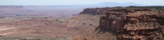
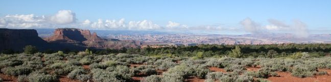
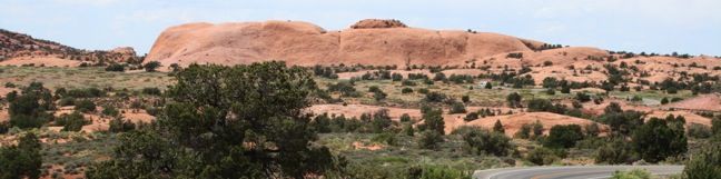
Hike Canyonlands Grand View Point Canyonlands National Park
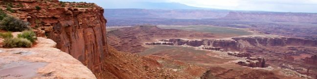
As the name implies, this is a hike with near endless views. Grand View Point is the southern-most spot on Canyonland's high mesa, the Island in the Sky. Laid out below is a complex network of canyons carved by the converging Colorado and Green Rivers. This 2-mile round trip hike leaves from Grand View Overlook and travels down the mesa's edge for as far as you can go without running out of real estate. ...Read more.
My Hikes: Completed hikeA green icon of shows a picture of a landscape with a check mark in the upper right corner, signifying that this is a hike you would like to put on your completed list.OK! Add to trails I've hiked
My Hikes: Want to hikeA green icon of shows a picture of a landscape with a heart in the upper right corner, signifying that this is a hike you would like to put on your to-do list.OK! Add to trails I want to hike
TagsA green icon depicting a tags represents a list of words and phrases that this content is tagged with Tagged with · Island in the Sky
Hike DistanceA green icon of a hiker used to label information about the length of the hike Distance: 2 miles · Elevation change: 80 feet
By: Published: Last updated: September 10, 2018
Visit Canyonlands national park overlooks
The Island in the Sky offers great views for visitors who aren't in favor of exploring too far from their transportation. Even for hikers, every overlook in the Island in the Sky in worth checking out. The two viewpoints should not be missed are Grand View Overlook and Green River Overlook. These provide excellent views along with informative panels. ...Read more.
TagsA green icon depicting a tags represents a list of words and phrases that this content is tagged with Tagged with · Island in the Sky
By: Published: Last updated: July 1, 2025
White Rim Overlook Hike Canyonlands National Park Utah
The Island in the Sky district of Canyonlands National Park is renowned for elevated views of immense canyons. One of the best east-facing vistas is White Rim Overlook, which offers sweeping 300-degree views from the mid-point a 1.8-mile round trip hike. From the picnic area a mile from the end of Grand View Road, hike east down the trail for a tenth of a mile and turn right at the junction. ...Read more.
My Hikes: Completed hikeA green icon of shows a picture of a landscape with a check mark in the upper right corner, signifying that this is a hike you would like to put on your completed list.OK! Add to trails I've hiked
My Hikes: Want to hikeA green icon of shows a picture of a landscape with a heart in the upper right corner, signifying that this is a hike you would like to put on your to-do list.OK! Add to trails I want to hike
TagsA green icon depicting a tags represents a list of words and phrases that this content is tagged with Tagged with · Island in the Sky
Hike DistanceA green icon of a hiker used to label information about the length of the hike Distance: 1.8 miles · Elevation change: 170 feet
By: Published: Last updated: June 4, 2017
Murphy Point Hike Canyonlands National Park Utah
The 3.6-mile round trip hike to Murphy Point provides a peaceful outing with excellent views off the western end of the Island in the Sky. This is an excellent morning hike, when the sun first strikes the expansive canyons below the mesa. Alternatively, the wide western view also makes this a recommended sunset trail. The trail is downhill most of the way with only 150 feet of elevation to contend with. ...Read more.
My Hikes: Completed hikeA green icon of shows a picture of a landscape with a check mark in the upper right corner, signifying that this is a hike you would like to put on your completed list.OK! Add to trails I've hiked
My Hikes: Want to hikeA green icon of shows a picture of a landscape with a heart in the upper right corner, signifying that this is a hike you would like to put on your to-do list.OK! Add to trails I want to hike
TagsA green icon depicting a tags represents a list of words and phrases that this content is tagged with Tagged with · Island in the Sky
Hike DistanceA green icon of a hiker used to label information about the length of the hike Distance: 3.6 miles · Elevation change: 150 feet
By: Published: Last updated: June 4, 2017
Mesa Arch Trail Hike Utah Canyonlands National Park Utah
Mesa Arch is an easy to visit landmark in the Island in the Sky region of Canyonlands National Park. This pothole arch spans across the mesa's edge, framing a scenic canyon vista. A 0.7-mile loop trail brings you right up to Mesa Arch, one of the park's most popular points of interest. A nature guide is available at the trailhead, and can be used to learn more about park vegetation and geology. ...Read more.
My Hikes: Completed hikeA green icon of shows a picture of a landscape with a check mark in the upper right corner, signifying that this is a hike you would like to put on your completed list.OK! Add to trails I've hiked
My Hikes: Want to hikeA green icon of shows a picture of a landscape with a heart in the upper right corner, signifying that this is a hike you would like to put on your to-do list.OK! Add to trails I want to hike
TagsA green icon depicting a tags represents a list of words and phrases that this content is tagged with Tagged with · Arches · Island in the Sky
Hike DistanceA green icon of a hiker used to label information about the length of the hike Distance: 0.7 miles · Elevation change: 75 feet
By: Published: Last updated: February 10, 2020
Aztec Butte Hike Canyonlands National Park Utah Hike Canyonlands
Aztec Butte is one of the more unique hikes in the Island in the Sky region of Canyonlands National Park. The trail crosses level grasslands and climbs a steep slope to a dome-shaped butte rising above the mesa. Alcoves along the rim of the butte house Puebloan granaries, which early inhabitants used for storage. A loop around the top of Aztec Butte visits two such granaries and provides excellent views into Taylor Canyon. ...Read more.
My Hikes: Completed hikeA green icon of shows a picture of a landscape with a check mark in the upper right corner, signifying that this is a hike you would like to put on your completed list.OK! Add to trails I've hiked
My Hikes: Want to hikeA green icon of shows a picture of a landscape with a heart in the upper right corner, signifying that this is a hike you would like to put on your to-do list.OK! Add to trails I want to hike
TagsA green icon depicting a tags represents a list of words and phrases that this content is tagged with Tagged with · Buttes · Island in the Sky
Hike DistanceA green icon of a hiker used to label information about the length of the hike Distance: 1.8 miles · Elevation change: 250 feet
By: Published: Last updated: June 4, 2017
Upheaval Dome Canyonlands National Park hike Utah Trail crater
Upheaval Dome in the most puzzling geological feature in Canyonlands National Park. A 1.7-mile hike visits two overlooks along the rim of this three-mile wide 1,000-foot deep crater. Geologists have two possible theories for what caused Upheaval Dome, which you can learn about along the trail. From the trailhead, a wide track heads to the right before turning uphill toward the crater. ...Read more.
My Hikes: Completed hikeA green icon of shows a picture of a landscape with a check mark in the upper right corner, signifying that this is a hike you would like to put on your completed list.OK! Add to trails I've hiked
My Hikes: Want to hikeA green icon of shows a picture of a landscape with a heart in the upper right corner, signifying that this is a hike you would like to put on your to-do list.OK! Add to trails I want to hike
TagsA green icon depicting a tags represents a list of words and phrases that this content is tagged with Tagged with · Craters · Island in the Sky
Hike DistanceA green icon of a hiker used to label information about the length of the hike Distance: 1.7 miles · Elevation change: 200 feet
By: Published: Last updated: May 13, 2025
Whale Rock Canyonlands National Park Hiking Trail
Surfacing above Upheaval Dome, Whale Rock is a unique natural feature on the western end of a magnificent mesa in Canyonlands National Park known as the Island in the Sky. Two popular theories explain how the bizarre dome/crater called Upheaval Dome came to be, but neither mentions how a whale of a rock ended up stretched across the mesa nearby. Whale Rock is long sandstone formation resembling a giant beached whale that came ashore on the Island in the Sky. ...Read more.
My Hikes: Completed hikeA green icon of shows a picture of a landscape with a check mark in the upper right corner, signifying that this is a hike you would like to put on your completed list.OK! Add to trails I've hiked
My Hikes: Want to hikeA green icon of shows a picture of a landscape with a heart in the upper right corner, signifying that this is a hike you would like to put on your to-do list.OK! Add to trails I want to hike
TagsA green icon depicting a tags represents a list of words and phrases that this content is tagged with Tagged with · Island in the Sky
Hike DistanceA green icon of a hiker used to label information about the length of the hike Distance: 1 mile · Elevation change: 250 feet
By: Published: Last updated: November 4, 2018