Riddle Lake hike Yellowstone National Park Trail
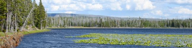
Riddle Lake Trail delivers an easy day hike across the Continental Divide to one of Yellowstone's backcountry lakes. The 5-mile round trip hike is almost as flat as the lake itself, with 100 hard-to-detect feet of elevation change. Riddle Lake is a beautiful blue body with a small beach. The lake is surrounded by lodgepole pine and mountain views. Even through the trail is easy enough for just about everyone, there is a good chance you will have the lake all to yourself, which is a bonus in this popular national park. ...Read more.
My Hikes: Completed hikeA green icon of shows a picture of a landscape with a check mark in the upper right corner, signifying that this is a hike you would like to put on your completed list.OK! Add to trails I've hiked
My Hikes: Want to hikeA green icon of shows a picture of a landscape with a heart in the upper right corner, signifying that this is a hike you would like to put on your to-do list.OK! Add to trails I want to hike
TagsA green icon depicting a tags represents a list of words and phrases that this content is tagged with Tagged with · Continental Divide · Lakes · National Parks
Hike DistanceA green icon of a hiker used to label information about the length of the hike Distance: 5 miles · Elevation change: 100 feet
By: Published: Last updated: January 10, 2018
Yellowstone National Park Mammoth Hot Springs Yellowstone National Park Upper Terrace Drive hydrothermal terraces Liberty Cap Minerva Terrace Palette Spring Canary Spring
Yellowstone National Park might have a lot of must see attractions, but you should not leave the park without visiting Mammoth Hot Springs. This impressive hydrothermal area may not have any high-spouting geysers, but it does have one of the world's greatest collections of hot springs with terraces made up of travertine deposits. The colorful steps and pools at Mammoth Hot Springs look more like something you would see in a cave next to stalactites than anything you are used to seeing above ground. ...Read more.
My Hikes: Completed hikeA green icon of shows a picture of a landscape with a check mark in the upper right corner, signifying that this is a hike you would like to put on your completed list.OK! Add to trails I've hiked
My Hikes: Want to hikeA green icon of shows a picture of a landscape with a heart in the upper right corner, signifying that this is a hike you would like to put on your to-do list.OK! Add to trails I want to hike
TagsA green icon depicting a tags represents a list of words and phrases that this content is tagged with Tagged with · Boardwalks · Hydrothermal · National Parks · Nature Trails
Hike DistanceA green icon of a hiker used to label information about the length of the hike Distance: 1.75 miles · Elevation change: 300 feet
By: Published: Last updated: January 10, 2018
Wraith Falls Trail Yellowstone National Park waterfall easy hike Wyoming
Yellowstone has lots of amazing natural features to explore, but sometimes it's the unassuming trail that delivers the most surprising enjoyment. Wraith Falls is not one of Yellowstone's biggest or boldest waterfalls, but the 0.8-mile round trip hike to the 100-foot streaking cascade is as pleasant as it is easy. After making a beeline across a grassy meadow to the creek below Wraith Falls, the trail turns uphill, climbing fifty feet (out of a total of 100 feet of elevation gain) in the last tenth of a mile to a viewpoint of Wraith Falls. ...Read more.
My Hikes: Completed hikeA green icon of shows a picture of a landscape with a check mark in the upper right corner, signifying that this is a hike you would like to put on your completed list.OK! Add to trails I've hiked
My Hikes: Want to hikeA green icon of shows a picture of a landscape with a heart in the upper right corner, signifying that this is a hike you would like to put on your to-do list.OK! Add to trails I want to hike
TagsA green icon depicting a tags represents a list of words and phrases that this content is tagged with Tagged with · National Parks · Waterfalls
Hike DistanceA green icon of a hiker used to label information about the length of the hike Distance: 0.8 miles · Elevation change: 100 feet
By: Published: Last updated: July 24, 2025
Boiling River Trail Yellowstone National Park hike Gardner River Mammoth Hot Springs Wyoming hydrothermal swimming hike
While Boiling River Trail is about as easy and straightforward as they come, the destination is completely unconventionally. The 1.25-mile round trip hike ends at one of America's strangest swimming holes where a stream of water cooked by Yellowstone's hydrothermal features mixes with cold river water. Wear your bathing suit and take a dip in this remarkable hot springs! ...Read more.
My Hikes: Completed hikeA green icon of shows a picture of a landscape with a check mark in the upper right corner, signifying that this is a hike you would like to put on your completed list.OK! Add to trails I've hiked
My Hikes: Want to hikeA green icon of shows a picture of a landscape with a heart in the upper right corner, signifying that this is a hike you would like to put on your to-do list.OK! Add to trails I want to hike
TagsA green icon depicting a tags represents a list of words and phrases that this content is tagged with Tagged with · Hot Springs · Hydrothermal · National Parks
Hike DistanceA green icon of a hiker used to label information about the length of the hike Distance: 1.25 miles · Elevation change: 50 feet
By: Published: Last updated: May 13, 2025
Yellowstone National Park Campgrounds camping information camp places to tent camp in Yellowstone Slough Creek Campground
Yellowstone National Park has 12 developed campgrounds with over 2,000 available campsites during the peak summer season. Reservations are accepted at several of the park's campgrounds, Bridge Bay Campground, Canyon Campground, Fishing Bridge RV Campground, Grant Campground, and Madison Campground. These campgrounds are operated by a private company, Xanterra Parks and Resorts. ...Read more.
TagsA green icon depicting a tags represents a list of words and phrases that this content is tagged with Tagged with · National Parks · Tent Camping
By: Published: Last updated: June 29, 2025
Garden Wall Trail Grinnell Glacier Overlook Highline Trail hike Glacier National Park Montana Granite Park Chalet Continental Divide
Picture yourself standing on the Continental Divide overlooking a crackling glacier that feeds a string of sparkling turquoise lakes. That is only part of the panorama you'll enjoy from Glacier Overlook, a no-nonsense notch on a section of the Continental Divide in Glacier National Park named the Garden Wall. Approached from the west, Glacier Overlook offers a window looking east over a glacier and a trio of subalpine lakes. ...Read more.
My Hikes: Completed hikeA green icon of shows a picture of a landscape with a check mark in the upper right corner, signifying that this is a hike you would like to put on your completed list.OK! Add to trails I've hiked
My Hikes: Want to hikeA green icon of shows a picture of a landscape with a heart in the upper right corner, signifying that this is a hike you would like to put on your to-do list.OK! Add to trails I want to hike
TagsA green icon depicting a tags represents a list of words and phrases that this content is tagged with Tagged with · Continental Divide · National Parks
Hike DistanceA green icon of a hiker used to label information about the length of the hike Distance: 2 miles · Elevation change: 1000 feet
By: Published: Last updated: September 8, 2025
Highline Trail Glacier National Park Montana hike Logan Pass Garden Wall the loop
Rarely does a trail deliver as many breathtaking views as Highline Trail in Glacier National Park. This is one of the most incredible day hikes in Glacier (and therefore anywhere on the planet). Highline Trail begins on the Continental Divide, delivering lofty views right from the start. Things are pretty level for the first three miles, making it easy for less ambitious hikers to still snag some great views. ...Read more.
My Hikes: Completed hikeA green icon of shows a picture of a landscape with a check mark in the upper right corner, signifying that this is a hike you would like to put on your completed list.OK! Add to trails I've hiked
My Hikes: Want to hikeA green icon of shows a picture of a landscape with a heart in the upper right corner, signifying that this is a hike you would like to put on your to-do list.OK! Add to trails I want to hike
TagsA green icon depicting a tags represents a list of words and phrases that this content is tagged with Tagged with · Continental Divide · Going-to-the-Sun Road · National Parks
Hike DistanceA green icon of a hiker used to label information about the length of the hike Distance: 13.5 miles · Elevation change: 3400 feet
By: Published: Last updated: January 10, 2018
Grinnell Lake Trail Many Glacier Hotel Lake Josephine Swiftcurrent Lake hike Glacier National Park Montana
Grinnell Lake Trail offers a level hike along a string of glacier-fed lakes. The trail departs from Many Glacier Hotel on the northeast side of Glacier National Park. There are trails along opposite sides of two beautiful subalpine lakes preceding Grinnell Lake, as well as a short spur to a waterfall, that give hikers a few options. Also, a ferry service that transports guests from Many Glacier Hotel across the first two lakes for those who prefer less hiking and more on-the-water leisure. ...Read more.
My Hikes: Completed hikeA green icon of shows a picture of a landscape with a check mark in the upper right corner, signifying that this is a hike you would like to put on your completed list.OK! Add to trails I've hiked
My Hikes: Want to hikeA green icon of shows a picture of a landscape with a heart in the upper right corner, signifying that this is a hike you would like to put on your to-do list.OK! Add to trails I want to hike
TagsA green icon depicting a tags represents a list of words and phrases that this content is tagged with Tagged with · Lakes · National Parks · Waterfalls
Hike DistanceA green icon of a hiker used to label information about the length of the hike Distance: 7.5 miles · Elevation change: 300 feet
By: Published: Last updated: April 27, 2017
Glacier National Park Campgrounds camping information camp
Glacier National Park has over 1,000 campsites spread among 13 drive-up campgrounds. There is also an array of trail camps for backpackers. Reservations are accepted at 2 of the park's 13 campgrounds, Fish Creek Campground on the west side and Saint Mary Campground on the east side of the park. Lake McDonald from Fish Creek Campground Most campgrounds in Glacier National Park are situated in pine forests, often nestled next to lakes or creeks. ...Read more.
TagsA green icon depicting a tags represents a list of words and phrases that this content is tagged with Tagged with · National Parks · Tent Camping
By: Published: Last updated: June 30, 2025
Saint Mary Falls Trail Glacier National Park Montana hike Virginia Falls Saint Mary Lake cascades St. Mary Falls Waterfall
This 3-mile hike on the east side of Glacier National Park presents intimate views of two waterfalls on creeks flowing into Saint Mary Lake. Before the Mississippi-bound water from the Continental Divide reaches the grand lake, it spills over Saint Mary Falls and Virginia Falls, two easy-to-reach gushers that can be picked up as a pair. The trail descends 200 feet to Saint Mary Falls and then climbs 250 feet to Virginia Falls. ...Read more.
My Hikes: Completed hikeA green icon of shows a picture of a landscape with a check mark in the upper right corner, signifying that this is a hike you would like to put on your completed list.OK! Add to trails I've hiked
My Hikes: Want to hikeA green icon of shows a picture of a landscape with a heart in the upper right corner, signifying that this is a hike you would like to put on your to-do list.OK! Add to trails I want to hike
TagsA green icon depicting a tags represents a list of words and phrases that this content is tagged with Tagged with · Going-to-the-Sun Road · National Parks · Waterfalls
Hike DistanceA green icon of a hiker used to label information about the length of the hike Distance: 3 miles · Elevation change: 250 feet
By: Published: Last updated: January 10, 2018