Pebble Creek Trail Yellowstone National Park hike backpacking
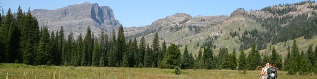
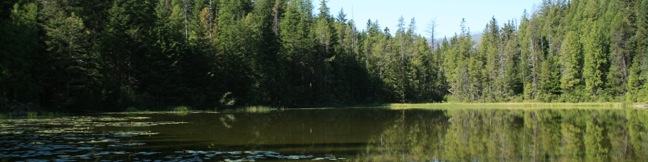
Starting just inside Yellowstone's northeast entrance near Cooke City, Montana, there is an interstate trail traveling through a beautiful backcountry meadow boxed in by 10,000-foot peaks. Pebble Creek Trail is often ventured as a top-to-bottom 12-mile long through hike ending at Pebble Creek Campground. There are five trail camps along Pebble Creek Trail for backpackers. ...Read more.
My Hikes: Completed hikeA green icon of shows a picture of a landscape with a check mark in the upper right corner, signifying that this is a hike you would like to put on your completed list.OK! Add to trails I've hiked
My Hikes: Want to hikeA green icon of shows a picture of a landscape with a heart in the upper right corner, signifying that this is a hike you would like to put on your to-do list.OK! Add to trails I want to hike
TagsA green icon depicting a tags represents a list of words and phrases that this content is tagged with Tagged with · Backpacking · Cooke City · Creeks · National Parks · Trail Camp · Walk-in Camping
Hike DistanceA green icon of a hiker used to label information about the length of the hike Distance: 12 miles · Elevation change: 950 feet
By: Published: Last updated: July 24, 2025
Boiling River Trail Yellowstone National Park hike Gardner River Mammoth Hot Springs Wyoming hydrothermal swimming hike
While Boiling River Trail is about as easy and straightforward as they come, the destination is completely unconventionally. The 1.25-mile round trip hike ends at one of America's strangest swimming holes where a stream of water cooked by Yellowstone's hydrothermal features mixes with cold river water. Wear your bathing suit and take a dip in this remarkable hot springs! ...Read more.
My Hikes: Completed hikeA green icon of shows a picture of a landscape with a check mark in the upper right corner, signifying that this is a hike you would like to put on your completed list.OK! Add to trails I've hiked
My Hikes: Want to hikeA green icon of shows a picture of a landscape with a heart in the upper right corner, signifying that this is a hike you would like to put on your to-do list.OK! Add to trails I want to hike
TagsA green icon depicting a tags represents a list of words and phrases that this content is tagged with Tagged with · Hot Springs · Hydrothermal · National Parks
Hike DistanceA green icon of a hiker used to label information about the length of the hike Distance: 1.25 miles · Elevation change: 50 feet
By: Published: Last updated: May 13, 2025
Garden Wall Trail Grinnell Glacier Overlook Highline Trail hike Glacier National Park Montana Granite Park Chalet Continental Divide
Picture yourself standing on the Continental Divide overlooking a crackling glacier that feeds a string of sparkling turquoise lakes. That is only part of the panorama you'll enjoy from Glacier Overlook, a no-nonsense notch on a section of the Continental Divide in Glacier National Park named the Garden Wall. Approached from the west, Glacier Overlook offers a window looking east over a glacier and a trio of subalpine lakes. ...Read more.
My Hikes: Completed hikeA green icon of shows a picture of a landscape with a check mark in the upper right corner, signifying that this is a hike you would like to put on your completed list.OK! Add to trails I've hiked
My Hikes: Want to hikeA green icon of shows a picture of a landscape with a heart in the upper right corner, signifying that this is a hike you would like to put on your to-do list.OK! Add to trails I want to hike
TagsA green icon depicting a tags represents a list of words and phrases that this content is tagged with Tagged with · Continental Divide · National Parks
Hike DistanceA green icon of a hiker used to label information about the length of the hike Distance: 2 miles · Elevation change: 1000 feet
By: Published: Last updated: September 8, 2025
Highline Trail Glacier National Park Montana hike Logan Pass Garden Wall the loop
Rarely does a trail deliver as many breathtaking views as Highline Trail in Glacier National Park. This is one of the most incredible day hikes in Glacier (and therefore anywhere on the planet). Highline Trail begins on the Continental Divide, delivering lofty views right from the start. Things are pretty level for the first three miles, making it easy for less ambitious hikers to still snag some great views. ...Read more.
My Hikes: Completed hikeA green icon of shows a picture of a landscape with a check mark in the upper right corner, signifying that this is a hike you would like to put on your completed list.OK! Add to trails I've hiked
My Hikes: Want to hikeA green icon of shows a picture of a landscape with a heart in the upper right corner, signifying that this is a hike you would like to put on your to-do list.OK! Add to trails I want to hike
TagsA green icon depicting a tags represents a list of words and phrases that this content is tagged with Tagged with · Continental Divide · Going-to-the-Sun Road · National Parks
Hike DistanceA green icon of a hiker used to label information about the length of the hike Distance: 13.5 miles · Elevation change: 3400 feet
By: Published: Last updated: January 10, 2018
Grinnell Lake Trail Many Glacier Hotel Lake Josephine Swiftcurrent Lake hike Glacier National Park Montana
Grinnell Lake Trail offers a level hike along a string of glacier-fed lakes. The trail departs from Many Glacier Hotel on the northeast side of Glacier National Park. There are trails along opposite sides of two beautiful subalpine lakes preceding Grinnell Lake, as well as a short spur to a waterfall, that give hikers a few options. Also, a ferry service that transports guests from Many Glacier Hotel across the first two lakes for those who prefer less hiking and more on-the-water leisure. ...Read more.
My Hikes: Completed hikeA green icon of shows a picture of a landscape with a check mark in the upper right corner, signifying that this is a hike you would like to put on your completed list.OK! Add to trails I've hiked
My Hikes: Want to hikeA green icon of shows a picture of a landscape with a heart in the upper right corner, signifying that this is a hike you would like to put on your to-do list.OK! Add to trails I want to hike
TagsA green icon depicting a tags represents a list of words and phrases that this content is tagged with Tagged with · Lakes · National Parks · Waterfalls
Hike DistanceA green icon of a hiker used to label information about the length of the hike Distance: 7.5 miles · Elevation change: 300 feet
By: Published: Last updated: April 27, 2017
Glacier National Park Campgrounds camping information camp
Glacier National Park has over 1,000 campsites spread among 13 drive-up campgrounds. There is also an array of trail camps for backpackers. Reservations are accepted at 2 of the park's 13 campgrounds, Fish Creek Campground on the west side and Saint Mary Campground on the east side of the park. Lake McDonald from Fish Creek Campground Most campgrounds in Glacier National Park are situated in pine forests, often nestled next to lakes or creeks. ...Read more.
TagsA green icon depicting a tags represents a list of words and phrases that this content is tagged with Tagged with · National Parks · Tent Camping
By: Published: Last updated: June 30, 2025
Saint Mary Falls Trail Glacier National Park Montana hike Virginia Falls Saint Mary Lake cascades St. Mary Falls Waterfall
This 3-mile hike on the east side of Glacier National Park presents intimate views of two waterfalls on creeks flowing into Saint Mary Lake. Before the Mississippi-bound water from the Continental Divide reaches the grand lake, it spills over Saint Mary Falls and Virginia Falls, two easy-to-reach gushers that can be picked up as a pair. The trail descends 200 feet to Saint Mary Falls and then climbs 250 feet to Virginia Falls. ...Read more.
My Hikes: Completed hikeA green icon of shows a picture of a landscape with a check mark in the upper right corner, signifying that this is a hike you would like to put on your completed list.OK! Add to trails I've hiked
My Hikes: Want to hikeA green icon of shows a picture of a landscape with a heart in the upper right corner, signifying that this is a hike you would like to put on your to-do list.OK! Add to trails I want to hike
TagsA green icon depicting a tags represents a list of words and phrases that this content is tagged with Tagged with · Going-to-the-Sun Road · National Parks · Waterfalls
Hike DistanceA green icon of a hiker used to label information about the length of the hike Distance: 3 miles · Elevation change: 250 feet
By: Published: Last updated: January 10, 2018
Johns Lake Loop Trail Glacier National Park Montana McDonald Creek McDonald Lake Avalanche Trail
Johns Lake Loop starts as a pleasant trail through a mossy forest leading to a small lake, but this Glacier National Park hike has a lot more to offer. The trail follows a cascading creek past McDonald Falls, getting an eyeful of the water that feeds the expansive Lake McDonald. This varied 2-mile loop has just 225 feet of elevation gain, making it one of the easiest hikes on the west side of Glacier National Park. ...Read more.
My Hikes: Completed hikeA green icon of shows a picture of a landscape with a check mark in the upper right corner, signifying that this is a hike you would like to put on your completed list.OK! Add to trails I've hiked
My Hikes: Want to hikeA green icon of shows a picture of a landscape with a heart in the upper right corner, signifying that this is a hike you would like to put on your to-do list.OK! Add to trails I want to hike
TagsA green icon depicting a tags represents a list of words and phrases that this content is tagged with Tagged with · Creeks · Going-to-the-Sun Road · Lakes · National Parks
Hike DistanceA green icon of a hiker used to label information about the length of the hike Distance: 2 miles · Elevation change: 225 feet
By: Published: Last updated: April 27, 2017