Hikes in Mojave National Preserve
North of Joshua Tree and south of Death Valley, Mojave National Preserve resembles a bit of both. Since it is not a national park, MNP is short on facilities, but this absence creates the opportunity for a more intimate visit with the desert.
Highlights of Mojave National Preserve


Visit Mojave National Preserve
FACT: Mojave National Preserve has a larger dune field than Death Valley.
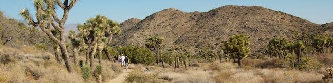
FACT: Mojave National Preserve has more Joshua trees than Joshua Tree.
FACT: Mojave National Preserve does not charge an entrance free.
So what are you waiting for?
Situated on 1.6 million acres, Mojave National Preserve is less-visited park that offers many natural attractions. To help get started, visit the Kelso Depot Ranger Station. A worthy attraction in its own right, the ranger station resides inside an old train depot that was build by Union Pacific Railroads over a century ago. This is the perfect place to ask questions about the park and learn the history of locomotion through the desert.
Mojave boasts hundreds of miles of off-pavement trails for 4X4s. Two wheel drive vehicles will not have a problem visiting many of the roadside campsites and other attractions. You may also take a tour of Mitchell Caverns, which is located in a state run nature preserve within the national preserve (a fee for the tour is required). Summer temperatures are in the triple digits, making November through April the best time to visit the park.
Mojave National Preserve Hiking
This collection of trails in Mojave National Preserve, California lists the hikes from north to south and west to east. The table can be sorted alphabetically or by distance to help you plan a trip to Mojave National Preserve. Each trail links to its own report complete with directions, photos, GPS maps, elevation profiles, and everything else needed to explore Mojave National Preserve. You can also view hikes around Mojave National Preserve on the Hike Finder Map.
| Trail | Description | Distance | Location |
|---|---|---|---|
 380 380 | Teutonia Peak This out and back hike crosses the world's densest Joshua tree forest, passing an abandoned silver mine to reach a rocky summit with views of Cima Dome. | 3.4 - 4 miles 700 feet | 35.31625, -115.5525 |
 390 390 | New York Peak This out and back hike summits the highest point of the New York Range in the northeast corner of the preserve. | 7 - 9 miles 2400 feet | 35.27675, -115.2518 |
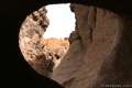
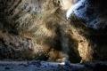 400 400 | Lava Tube This short out and back hike drops underground into an old lava tube lit by holes in the surface. | 0.6 miles 150 feet | 35.21378, -115.7532 |
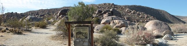
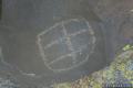 410 410 | Petroglyphs near Seventeen Mile Point This faint path visits ancient engravings in the volcanic rock at the western rim of the cinder fields just off Kelbaker Road. | 0.25 miles 25 feet | 35.205572, -115.872077 |
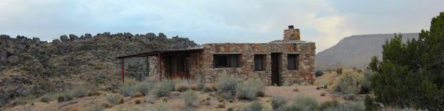
 417 417 | Rock Spring Loop Trail This loop visits a rare desert spring, a Rock House built in the 1920s, a miners' mill site, and an old U.S. Army post on a short and scenic circuit. | 1.33 miles 100 feet | 35.15502, -115.3348 |
 420 420 | Hole-in-the-Wall Rings Trail This loop takes visitors through a landscape of pocketed rocks. Ringbolts allow fun passage through narrow canyons. | 0.5 - 1.5 miles 150 feet | 35.0440, -115.3980 |
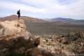
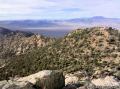
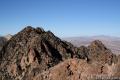 430 430 | Fountain Peak This off trail trek summits a peak with commanding views over the Providence Mountains. | 5 miles 2700 feet | 34.9432, -115.51268 |
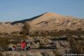 440 440 | Kelso Dunes This out and back hike climbs the highest point in this 45 square mile dune field. | 3 miles 470 feet | 34.89235, -115.69906 |
 450 450 | Silver Peak This out and back hike summits a 6,365-foot peak in the Granite Mountains. | 8.5 miles 2,500 feet | 34.8206, -115.6476 |
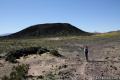 500 500 | Amboy Crater This out and back hike travels up and into a volcanic crater near Mojave National Preserve. | 3 miles 275 feet | 34.5572, -115.7814 |
Or explore hikes around Mojave National Preserve on the Hike Finder Map
Are you looking for other places to explore around Mojave National Preserve? The California desert has more great parks to visit, like: