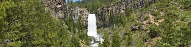
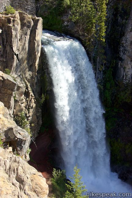
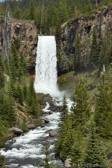
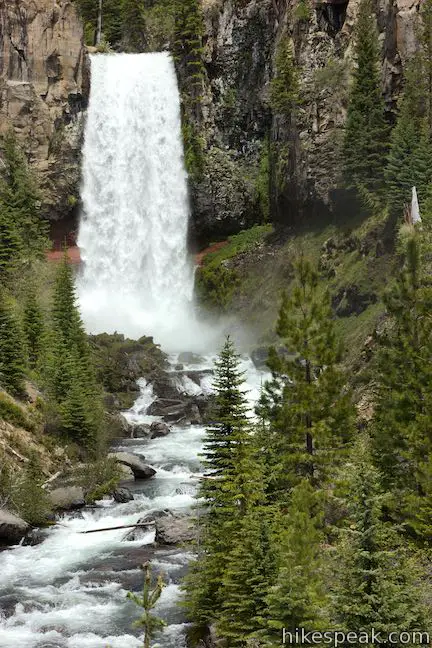
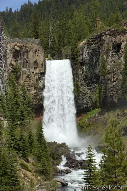
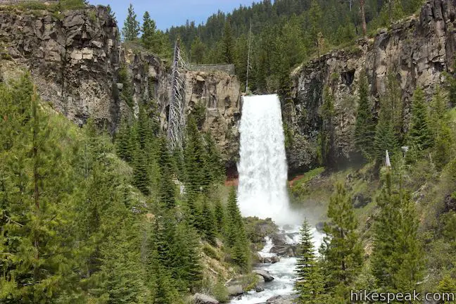
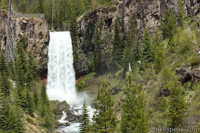
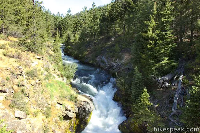
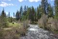
Tumalo Falls is rightfully considered one of the must-see attractions in Bend, Oregon. The grandest waterfall on Tumalo Creek makes a nearly 100-foot drop from a cliff in Deschutes National Forest west of Bend. Admire the broad single-drop waterfall from a downstream viewpoint that is fifty yards from Tumalo Falls Day Use Area. Then take a half a mile round trip hike to an overlook at the brink of the falls for a close-up look at the first-class gusher. North Fork Trail continues above Tumalo Falls, allowing persistent hikers to check out several other waterfalls and form a 7.4-mile Tumalo Falls Loop by returning on Swampy Lakes Trail and Bridge Creek Trail.
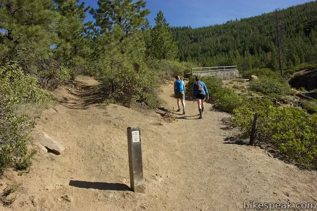
Tumalo Falls Day Use Area is a 14-mile drive from Bend at the end of Tumalo Falls Road (Forest Road 4603). Set out from a parking lot just after a bridge crossing Tumalo Creek downstream from the waterfall.
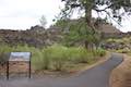
Walk to the trailhead kiosk next to the bathrooms and begin up the trail. You’ll come to a junction after a short distance where North Fork Trail parts to the left and ascends toward the top of Tumalo Falls. Head to the right first and walk a hundred feet to an arresting viewpoint.
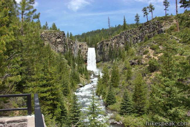
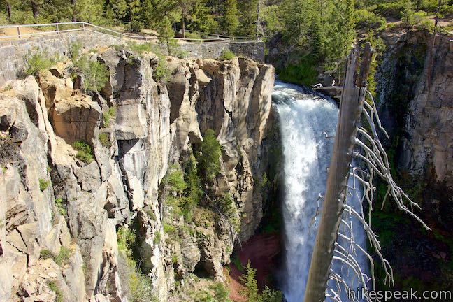
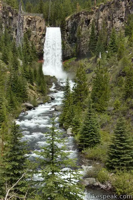
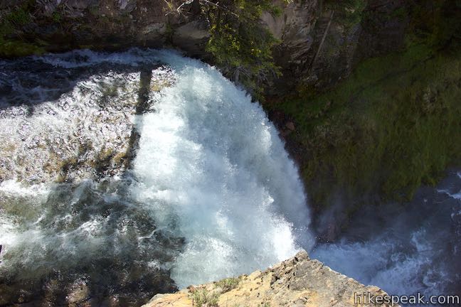
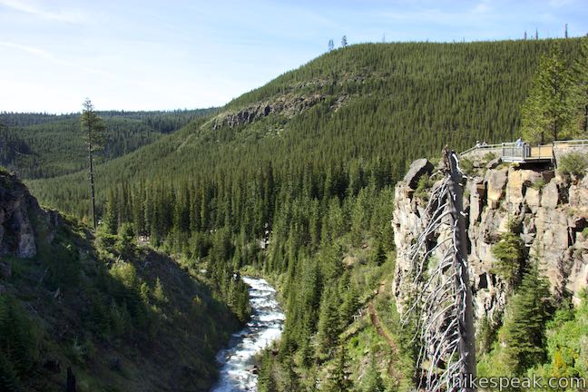
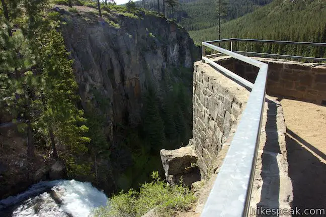
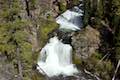
Look 200 yards up a sparsely pine-covered valley toward Tumalo Falls, which drops in a column of white water from a rock ledge. Tumalo Falls is measured at either 89 or 97 feet tall and both numbers probably downplay the waterfall’s beauty. Above the left side of the waterfall, spot the overlook at the brink of Tumalo Falls, which has a stone wall with a metal railing.
Did the opening view of Tumalo Falls inspire you to hike farther? Backtrack to the junction and begin up North Fork Trail.
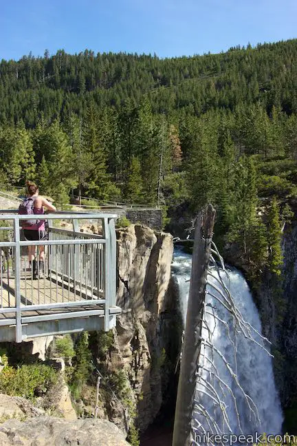
As the trail rises through ponderosa pines, you will pass a junction with Bridge Creek Trail, which parts to the left (the return route for the larger Tumalo Falls Loop). Proceed up North Fork Trail and come to a split. A waterfall-bypassing branch of North Fork Trail veers to the left. Stay to the right to see the overlook on the cliff’s edge by Tumalo Falls.
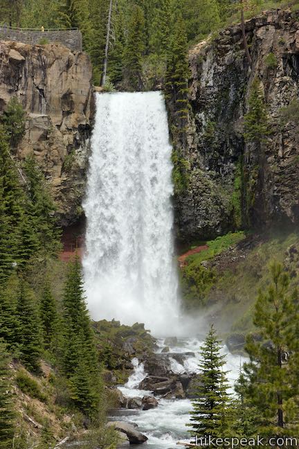
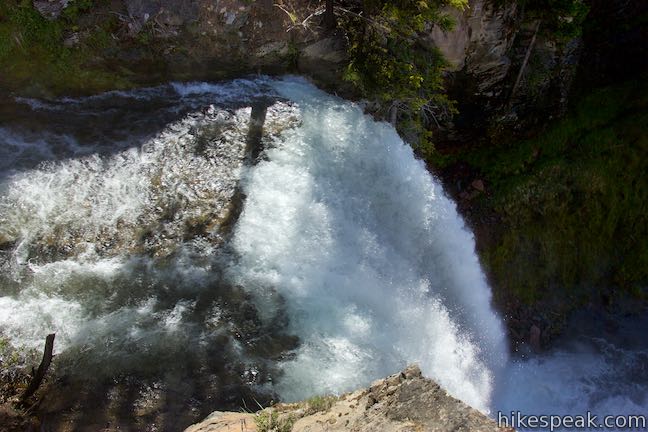
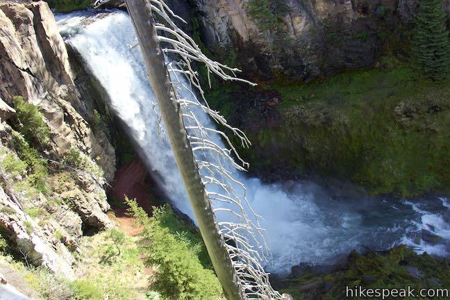
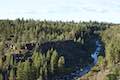
As you walk up to the top of Tumalo Falls, look down the canyon below the waterfall, where conifer-covered ridges frame Tumalo Creek. Approach Tumalo Falls at the brink of its plunge into the valley. The waterfall courses from the cliffs right next to the overlook and swiftly falls away to the ground below. Tumalo Falls is a definite beauty.
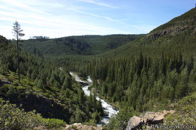
Turn around at the overlook beside Tumalo Falls to hike a quarter mile back to the day use area, descending just over 100 feet. Continue up North Fork Trail to see additional waterfalls and connect to Swampy Lakes Trail for Tumalo Falls Loop. If you don’t wish to hike that far, but still want to extend things a bit, consider hiking another 1.7 miles round trip (gaining 200 feet) on North Fork Trail to Double Falls. Push beyond that up to Middle Tumalo Falls (a.k.a. Upper Falls), extending the round trip distance above Tumalo Falls by 3.6 miles and 450 feet of elevation change. Read the write-up for Tumalo Falls Loop for more information about North Fork Trail above Tumalo Falls.
Tumalo Falls is not just a source of local pride; an adjacent branch of Tumalo Creek provides the local drinking water. The water intake for the city of Bend is just above Tumalo Falls Day Use Area. Dogs are allowed on North Fork Trail but are not allowed on Swampy Lakes Trail and Bridge Creek Trail through the City of Bend Watershed. Bike traffic on North Fork Trail is permitted in one direction only, going uphill. Bikes are also prohibited from passing through the watershed area. A $5 day use fee is required to park at either trailhead in Deschutes National Forest (price as of 2016). A Northwest Forest Pass or America the Beautiful public lands pass can be used in place of the day use fee. Tumalo Falls Road and Tumalo Falls Day Use Area close down during the winter and spring months due to snow. The trailhead is typically accessibly from May through October. No permit is required to hike to Tumalo Falls, so get out and enjoy!
To get to the trailhead: Take Route 97 to exit 138 in Bend, following signs for downtown and Mount Bachelor. At the end of the offramp, head west on Colorado Avenue (Cascade Lakes National Scenic Byway). Drive one mile, crossing the Deschutes River. At the traffic circle that follows, take the first exit (like a right turn) onto Simpson Avenue. Drive three blocks and go through the traffic circle at the intersection of Century Drive to stay on Simpson Avenue. Drive 0.6 miles to the next traffic circle and take the first exit (like a right turn) onto Mount Washington. Drive 0.8 miles and reach another traffic circle at the intersection with Skyliners Road. Take the third exit (which would be like a left turn and a standard intersection) and proceed west on Skyliners Road. Drive 8.8 miles up this road and bear right at an intersection. The road becomes unpaved and crosses Tumalo Creek. On the other side, turn left up Tumalo Falls Road (National Forest Road 4603) and drive 2.4 miles up to Tumalo Falls Day Use Area at road’s end.
Trailhead address: Tumalo Falls Road, Bend, OR 97701
Trailhead coordinates: 44.032, -121.56635 (44° 01′ 55.19″N 121° 33′ 58.85″W)
View Tumalo Falls in a larger map
Or view a regional map of surrounding Oregon trails and campgrounds.


 | Tumalo Falls Loop Venture above Tumalo Falls and explores numerous other waterfalls and cascades on Tumalo Creek, combining North Fork Trail, Swampy Lakes Trail, and Bridge Creek Trail for a 7.4-mile circuit. |
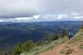
 | Pilot Butte This 1.8-mile hike ventures up the dominant landmark in Bend to offer sweeping views of the majestic surroundings. |
 | Archie Briggs Canyon Trail This 1.25-mile hike descends a ravine to clifftop views over a dramatic canyon on the Deschutes River. |
 | Shevlin Loop Trail This 4.75-mile tour of Shevlin Park just a few miles east of Bend explores pine forests on both sides of Tumalo Creek. |
 | Lava Butte This hike explores a cinder cone with a fire lookout tower and a crater-circling trail that offer panoramic views over Lava Butte Lava Flow and the Cascade Mountains. |
 | Trail of the Molten Land This 1.1-mile long paved partial loop cuts through Lava Butte Lave Flow and is packed with information and views. |
 | Trail of the Whispering Pines This interpretive botanical trail explores high desert plants on the edge of Lava Butte Lava Flow on a quarter-mile long path. |
 | Lava River Cave This underground hike explores a lava tube south of Bend that is filled with fascinating volcanic features. |
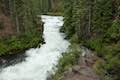 | Deschutes River Trail to Benham Falls This 1.9-mile hike follows a leisurely trail along the Deschutes River to aggressive cascades called Benham Falls where the river churns and tumbles through a gap between cliffs. |
 | Black Butte The 4-mile hike summits one of the most identifiable peaks in Central Oregon, which has fire lookout towers and panoramic views of the Cascade Mountains. |
 | Head of the Metolius This 0.5-mile hike visits the surprising source of the Metolius River, a gushing spring accompanied by views of Mount Jefferson. |
 | West Metolius River Trail The 5.4-mile hike follows the west bank of the Metolius River to incredible gushing springs and a fish hatchery. |
 | More trails in Oregon Explore other hikes in Central Oregon, the Columbia River Gorge, and elsewhere. |
Tumalo Falls on waterfallsnorthwest.com
Tumalo Falls and North Fork Trail on cascadehikingadventures.com
Tumalo Falls and North Fork Trail on 100hikes.com
Tumalo Falls on takemytrip.com
Tumalo Falls on oregonhiking.com
Tumalo Falls Loop on thirddoor.com
Tumalo Falls Loop on outdoorproject.com
A national forest map of the Tumalo Trail System
The official Deschutes National Forest webpage for Tumalo Falls Day Use Area

[…] Tumalo Falls is found on the Tumalo Creek and has a height of 100 feet. The falls stand out in the region and have become a popular tourist destination. What makes these falls even more amazing is the stunning scenery it is located, the pristine water flow, and the hike involved in reaching the falls. Additionally, there are several small waterfalls around that are worth exploring. The canyon below is quite beautiful with trails of green and beautiful vegetation. For someone looking for an out-of-town experience, Tumalo offers unique experiences. […]