Latourell Falls Trail Waterfall hike Columbia River Gorge Talbot State Park Oregon Lower Latourell Falls loop trail to Upper Latourell Falls
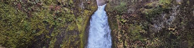
Latourell Falls is a stunning waterfalls tumbling into the Columbia River Gorge east of Portland. More precisely, there are two waterfalls on Latourell Creek totaling 359 feet of falls. Lower Latourell Falls is a beautiful 225-foot single drop waterfall that can be seen right from the trailhead along Historic Columbia River Highway. Farther up the canyon is Upper Latourell Falls, which is 134 feet tall, sliding down a basalt overhang before twisting to a freefalling plunge. ...Read more.
My Hikes: Completed hikeA green icon of shows a picture of a landscape with a check mark in the upper right corner, signifying that this is a hike you would like to put on your completed list.OK! Add to trails I've hiked
My Hikes: Want to hikeA green icon of shows a picture of a landscape with a heart in the upper right corner, signifying that this is a hike you would like to put on your to-do list.OK! Add to trails I want to hike
TagsA green icon depicting a tags represents a list of words and phrases that this content is tagged with Tagged with · Cascade Range · Free Trails · Guy W. Talbot State Park · Oregon State Parks · Waterfalls
Hike DistanceA green icon of a hiker used to label information about the length of the hike Distance: 2.3 miles · Elevation change: 475 feet
By: Published: February 12, 2015 Last updated: January 9, 2018
Wahclella Falls Trail Waterfall hike Portland Oregon Columbia River Gorge Tanner Creek
If you were designing a landscape just for waterfalls, you would end up with something not unlike the Columbia River Gorge. Dozens of waterfalls spill from the basalt cliffs in this region. The abundance of water creates mossy natural retreats that could barely be matched even if you were designing a landscape from scratch. Multnomah Falls is the tallest waterfall in the area, and while Wahclella Falls is not as grand (its two tiers total 130 feet), it is quite charming and the trail to the waterfall is a lot less crowded. ...Read more.
My Hikes: Completed hikeA green icon of shows a picture of a landscape with a check mark in the upper right corner, signifying that this is a hike you would like to put on your completed list.OK! Add to trails I've hiked
My Hikes: Want to hikeA green icon of shows a picture of a landscape with a heart in the upper right corner, signifying that this is a hike you would like to put on your to-do list.OK! Add to trails I want to hike
TagsA green icon depicting a tags represents a list of words and phrases that this content is tagged with Tagged with · Cascade Range · Columbia River Gorge National Scenic Area · Free Trails · Waterfalls
Hike DistanceA green icon of a hiker used to label information about the length of the hike Distance: 2 miles · Elevation change: 250 feet
By: Published: October 15, 2011 Last updated: July 27, 2023
Multnomah Falls Trail Waterfall hike Portland Oregon Columbia River Gorge
Multnomah Falls is the tallest waterfall in Oregon and one of the tallest year-round waterfalls in the United States. The 620-foot waterfall is grand, beautiful, and easy to reach, making it one of the most popular outdoor attractions in the Pacific Northwest. Located in the Columbia River Gorge on the Washington - Oregon border, 30 miles east of Portland, Multnomah Falls offers something for hikers of all abilities. ...Read more.
My Hikes: Completed hikeA green icon of shows a picture of a landscape with a check mark in the upper right corner, signifying that this is a hike you would like to put on your completed list.OK! Add to trails I've hiked
My Hikes: Want to hikeA green icon of shows a picture of a landscape with a heart in the upper right corner, signifying that this is a hike you would like to put on your to-do list.OK! Add to trails I want to hike
TagsA green icon depicting a tags represents a list of words and phrases that this content is tagged with Tagged with · Cascade Range · Columbia River Gorge National Scenic Area · Free Trails · Waterfalls
Hike DistanceA green icon of a hiker used to label information about the length of the hike Distance: 0.4 miles · Elevation change: 25 feet
By: Published: October 12, 2011 Last updated: May 13, 2025