Arthur’s Pass National Park

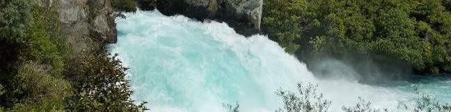
[wp_ad_content_square_lower]Motorists travel over Arthur's Pass when crossing the Southern Alps between the east and west coasts of New Zealand's South Island. Massive peaks surround the pass, skirted by beech forests that enclose alluring waterfalls. It's well worth stopping along State Highway 73 as it crosses through Arthur's Pass National Park to take a closer look. ... Read more.
Matariki Motor Lodge in Te Awamutu
Tucked in between the land of hobbits and the land of glowworms, Matariki Motor Lodge offers well-kept accommodations in the quaint town of Te Awamutu on the North Island of New Zealand. The motor lodge is a 40-minute drive from Hobbiton in Matamata to the northeast and 40 minutes from the Waitomo Glowworm Caves and other outdoor fun around Waitomo to the southwest. ...Read more.
By: Published: April 30, 2015 Last updated: December 5, 2025
Rathmoy Lodge in Rangitikei
Rathmoy Lodge isn't just a place to spend the night; it's a destination. The lodge sits on a private and picturesque bend on the Rangitikei River surrounded by a working sheep and cattle farm. Located on the North Island of New Zealand, the lodge is near State Highway 1 by the town of Hunterville, two and a half hours north of Wellington. Rathmoy Lodge is an ideal spot for a relaxing outdoor getaway for a family or a couple. ...Read more.
Tagged with · Accommodations · Hunterville · Lodge · Rangitikei
By: Published: April 22, 2015 Last updated: April 15, 2026
Whitecliffs Boulders in Rangitikei
Nature produces some surprising creations, like the large, freakishly round boulders found along the Rangitikei River on the North Island of New Zealand. The boulders, known as cannonball concretions, are clustered in a moss-covered forest that is charming to walk through. Take a 4.1-kilometer (2.55-mile) walk across Whitecliffs Farm and up the Rangitikei River to the boulders. ...Read more.
Tagged with · Concretions · Mangaweka · Rangitikei
Distance: 4.1 kilometers / 2.55 miles · Elevation change: 140 meters / 460 feet
By: Published: April 14, 2015 Last updated: December 7, 2025
Spa Thermal Park – Huka Falls Walkwayin Taupo
Above Huka Falls, the Waikato River presses through a ravine of sheer rock cliffs, creating a churning canal of rapids. At the end of this ravine, the water surges out as Huka Falls, where it makes a powerful push into the river below. To see the waterfall and the ravine, visitors can simply walk 200 meters from a car park by Huka Falls. To add a walk along Waikato River to the itinerary, set out on Spa Thermal Park in Taupo. ...Read more.
Distance: 7.3 kilometers / 4.5 miles · Elevation change: 45 meters / 150 feet
By: Published: March 17, 2015 Last updated: April 9, 2026
Lake Rotopounamu in Tongariro National Park
With scenery that is more verdant than the volcanic landscapes at the center of Tongariro National Park, Lake Rotopounamu Track provides a peaceful walk to a small, forest-cradled lake with inviting beaches. Lake Rotopounamu, which is also know as Greenstone Lake, covers one square kilometer. Lake Rotopounamu Loop Track circles the lake for a hike that's 6. ...Read more.
Distance: 6.4 kilometers / 4 miles · Elevation change: 90 meters / 295 feet
By: Published: March 13, 2015 Last updated: December 6, 2025