Lava River Cave Bend Oregon Lava Tube Newberry National Volcanic Monument Oregon Deschutes National Forest
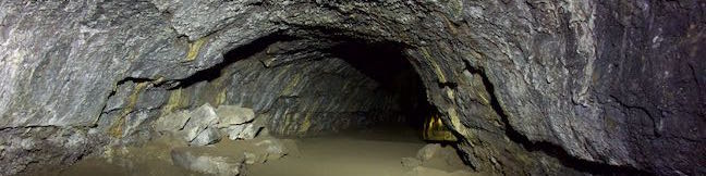
Lava River Cave is the longest lava tube in Oregon and is fascinating to explore. Put fresh batteries in your flashlights and head to Newberry National Volcanic Monument, which is in Deschutes National Forest just a dozen miles south of Bend. Walking through Lava River Cave, you will see wild features left behind by volcanic eruptions 100,000 years ago. After a mile in the dark, venture... Read more.
My Hikes: Completed hikeA green icon of shows a picture of a landscape with a check mark in the upper right corner, signifying that this is a hike you would like to put on your completed list.OK! Add to trails I've hiked
My Hikes: Want to hikeA green icon of shows a picture of a landscape with a heart in the upper right corner, signifying that this is a hike you would like to put on your to-do list.OK! Add to trails I want to hike
TagsA green icon depicting a tags represents a list of words and phrases that this content is tagged with Tagged with · Bend · Caves · Deschutes National Forest · Lava Butte Lava Flow · Lava Tubes · Newberry National Volcanic Monument · Sunriver
Hike DistanceA green icon of a hiker used to label information about the length of the hike Distance: 2.2 miles · Elevation change: 150 feet
By: Published: Last updated: May 19, 2024
Cape Lookout Trail Coastal Hike Cape Lookout State Park Oregon
Treat yourself to gargantuan ocean views from the edges of Cape Lookout, hiking 5 miles round trip to a viewpoint at the end of this tall promontory on the Oregon Coast. Cape Lookout Trail passes through a temperate rainforest packed with tall cedars. The forest is wild and beautiful and so is the surrounding coastline. Cape Lookout is probably the most impressive cape on Three Capes Scenic... Read more.
My Hikes: Completed hikeA green icon of shows a picture of a landscape with a check mark in the upper right corner, signifying that this is a hike you would like to put on your completed list.OK! Add to trails I've hiked
My Hikes: Want to hikeA green icon of shows a picture of a landscape with a heart in the upper right corner, signifying that this is a hike you would like to put on your to-do list.OK! Add to trails I want to hike
TagsA green icon depicting a tags represents a list of words and phrases that this content is tagged with Tagged with · Cape Lookout State Park · Ocean Views · Oregon State Parks · Three Capes Scenic Route · Tillamook
Hike DistanceA green icon of a hiker used to label information about the length of the hike Distance: 5 miles · Elevation change: 440 feet
By: Published: Last updated: June 28, 2021
Marquam Nature Park Loop Hike West Hills Southwest Portland Oregon Marquam Trail
Marquam Nature Park is walking distance from downtown Portland, but is tucked away and remains less well known than other parks in the West Hills. Marquam Nature Park provides ample woodland solitude, despite its proximity to downtown. Explore this underused parcel of the West Hills near OHSU on a multi-trail loop hike. To see most of the park, combine Shelter Loop Trail, Marquam Trail,... Read more.
My Hikes: Completed hikeA green icon of shows a picture of a landscape with a check mark in the upper right corner, signifying that this is a hike you would like to put on your completed list.OK! Add to trails I've hiked
My Hikes: Want to hikeA green icon of shows a picture of a landscape with a heart in the upper right corner, signifying that this is a hike you would like to put on your to-do list.OK! Add to trails I want to hike
TagsA green icon depicting a tags represents a list of words and phrases that this content is tagged with Tagged with · Free Trails · Marquam Nature Park · Southwest Portland · Tualatin Mountains · West Hills of Portland
Hike DistanceA green icon of a hiker used to label information about the length of the hike Distance: 4.25 miles · Elevation change: 500 feet
By: Published: Last updated: May 13, 2025
Shevlin Loop Trail Bend Oregon Hike Shevlin Park Tumalo Creek
Shevlin Loop Trail explores pine forests along Tumalo Creek in Shevlin Park, which is just four miles west of downtown Bend. This pleasant woodland trail is mostly easy with a few rolling sections along the bluffs that border the creek. The loop is 4.75 miles long and explores much of Shevlin Park's 647 acres. The hike has 240 feet of elevation change and crosses lovely Tumalo Creek at two... Read more.
My Hikes: Completed hikeA green icon of shows a picture of a landscape with a check mark in the upper right corner, signifying that this is a hike you would like to put on your completed list.OK! Add to trails I've hiked
My Hikes: Want to hikeA green icon of shows a picture of a landscape with a heart in the upper right corner, signifying that this is a hike you would like to put on your to-do list.OK! Add to trails I want to hike
TagsA green icon depicting a tags represents a list of words and phrases that this content is tagged with Tagged with · Bend · Cascade Range · Creeks · Free Trails · Shevlin Park · Tumalo Creek
Hike DistanceA green icon of a hiker used to label information about the length of the hike Distance: 4.75 miles · Elevation change: 240 feet
By: Published: Last updated: May 13, 2025
Archie Briggs Canyon Trail Bend Oregon Hike Deschutes River Trail Overlook
Archie Briggs Natural Area presents views over a dramatic stretch of the Deschutes River north of Bend. The river makes a sweeping curve beneath tall cliffs of volcanic rock and is backed by grand mountains like Black Butte and Mount Jefferson. Gaze down the canyon from atop cliffs on the south side of the curve in the river by an intersection of Deschutes River Trail and Archie Briggs... Read more.
My Hikes: Completed hikeA green icon of shows a picture of a landscape with a check mark in the upper right corner, signifying that this is a hike you would like to put on your completed list.OK! Add to trails I've hiked
My Hikes: Want to hikeA green icon of shows a picture of a landscape with a heart in the upper right corner, signifying that this is a hike you would like to put on your to-do list.OK! Add to trails I want to hike
TagsA green icon depicting a tags represents a list of words and phrases that this content is tagged with Tagged with · Archie Briggs Natural Area · Awbrey Butte · Bend · Cascade Range · Deschutes River · Free Trails
Hike DistanceA green icon of a hiker used to label information about the length of the hike Distance: 1.25 miles · Elevation change: 325 feet
By: Published: Last updated: December 21, 2017