
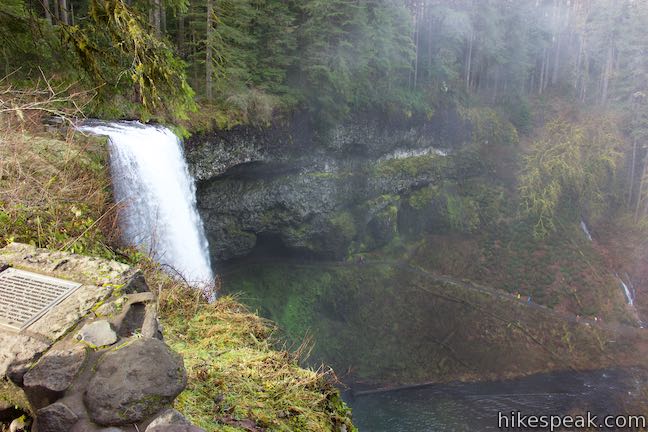
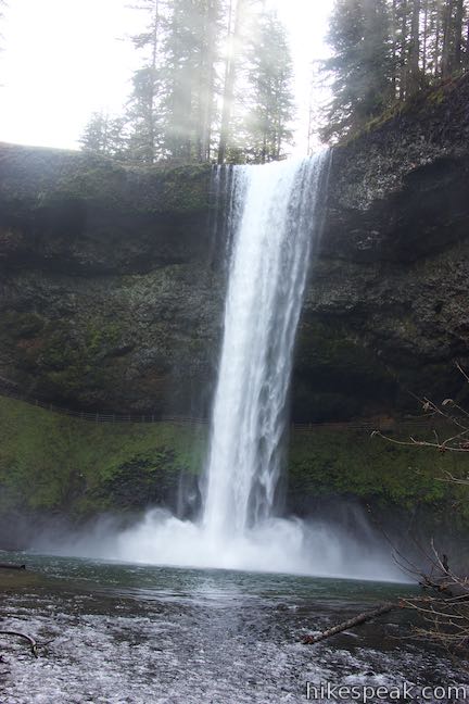
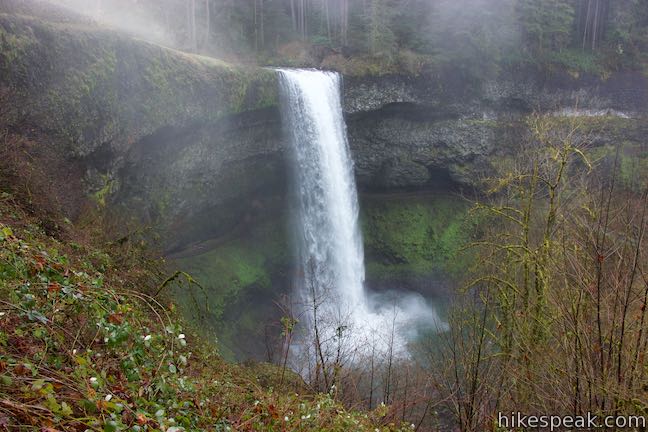
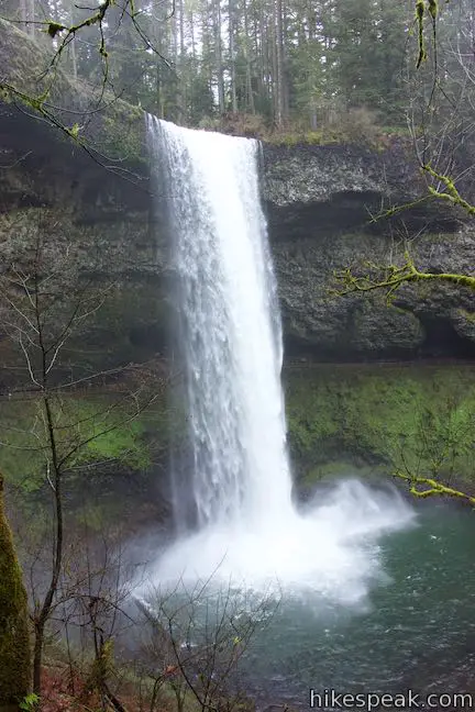
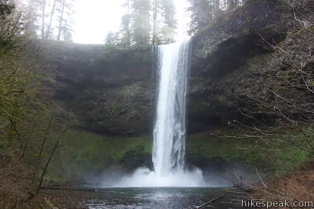
South Falls is the tallest waterfall in Silver Falls State Park, dropping a spectacular 177 feet off a basalt shelf. South Falls can be visited (along with nine other waterfalls) on the park’s great loop, the Trail of Ten Falls. When this 7.9-mile loop is too much, a 1.1-mile lollipop loop can be hiked to visit South Falls on its own. The short hike has 200 feet of elevation change. Start from South Falls Day Use Area, visit a viewpoint at the brink of the falls, make your way behind the waterfall, and cross a downstream bridge for great views of Silver Falls State Park’s most beloved jewel and one of Oregon’s most recognizable waterfalls.
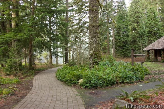
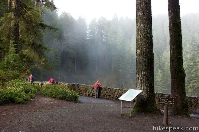
Set out from the large parking lot at the Silver Fall Day Use Area. Pass a bathroom and take a brick path alongside South Falls Lodge (or pop inside to take a look). The lodge and the Trail of Ten Falls were constructed by the Civilian Conservation Corps and Works Projects Administration between 1935 and 1942. A panel along the trail explains that the CCC and WPA workers completed 88 projects to built the long-standing infrastructure of Silver Falls State Park, which you can admire over the course of the hike.
A level 0.15 miles of hiking leads to a prominent trail junction at a spot called the Stone Circle. Follow signs for South Falls and turn left. It won’t be too long until you come to another junction where Maple Ridge Trail parts to the right. Stay to the left toward South Falls.
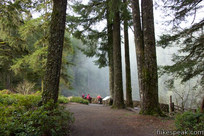
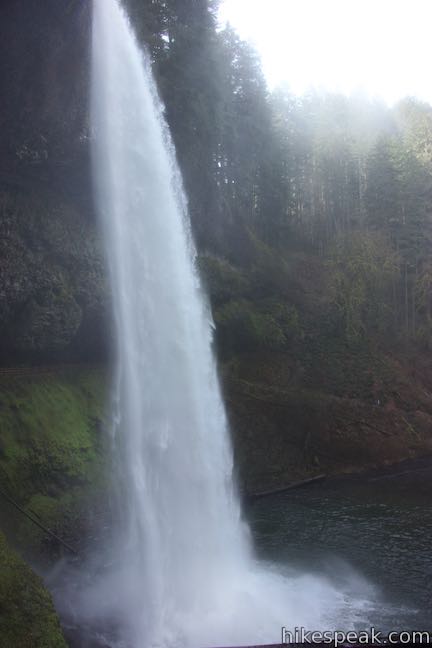
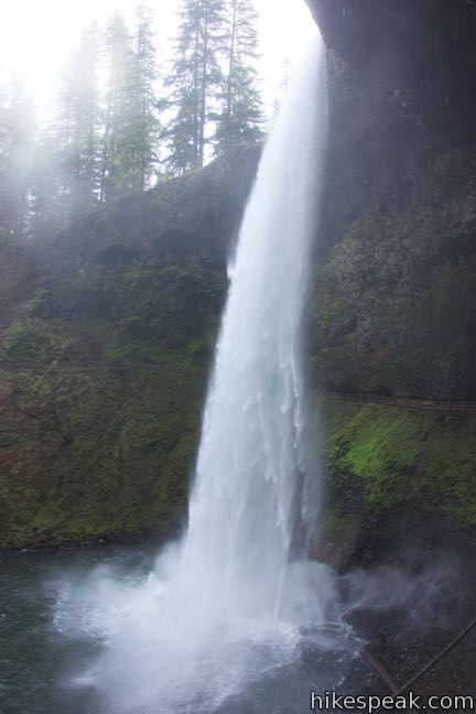
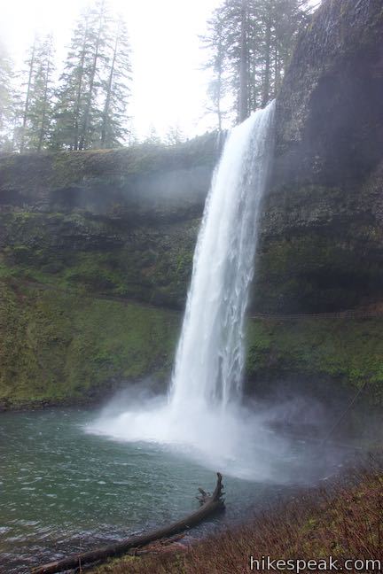
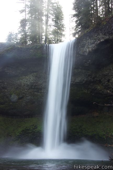
The forest opens up as you approach South Falls Viewpoint. Step out on the cliffs alongside South Falls. You are standing beside the brink of South Falls where the peacefully-flowing South Fork of Silver Creek suddenly plunges 177 feet into the canyon below. Watch mist rise from the waterfall, providing moisture for the mossy trees below.
South Falls Viewpoint is a quarter mile from the parking area over level terrain. To get better views of the single-drop waterfall, continue down Canyon Trail, which descends to the right.
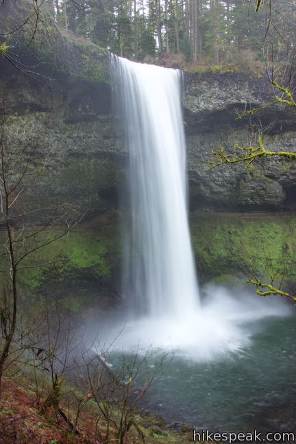
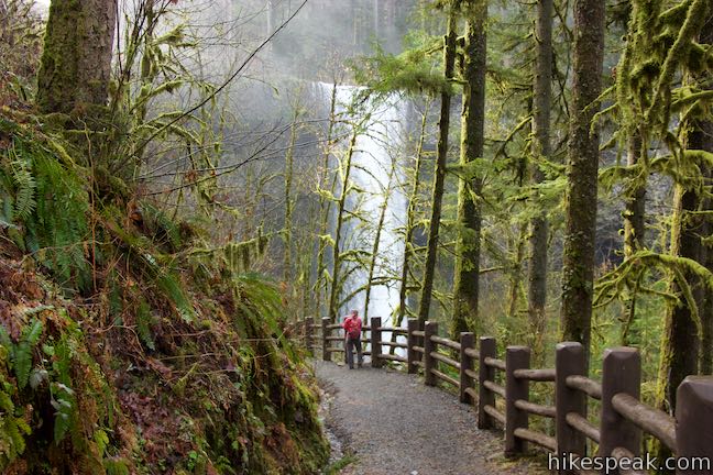
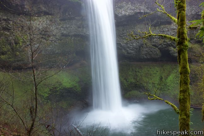
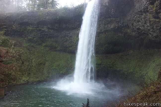
Canyon Trail eases down the bluff, buckling to the left around a switchback. This turn lines you up for head-on views of South Falls.
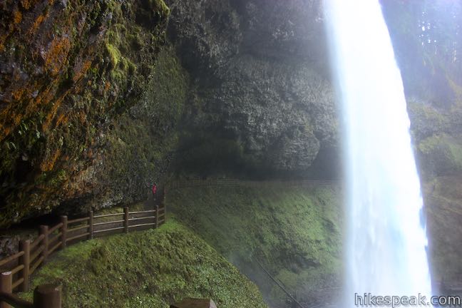
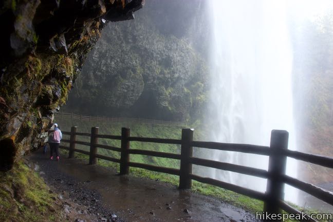
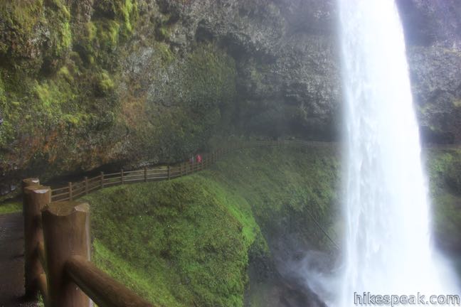
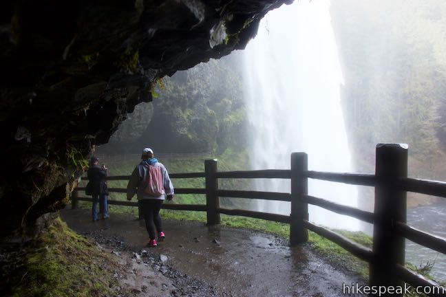
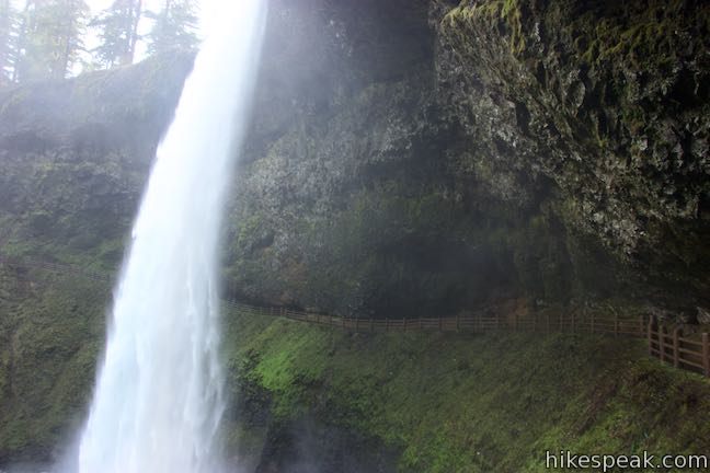
Come to a junction on the side of the canyon where the short loop visiting South Falls begins. A trail to the right goes down to a bridge below the waterfall. This will be the loop’s return route, unless you choose to reverse the directions. Turn left on an exciting trail that goes directly behind South Falls across ledges underneath the basalt cliff that the waterfall pours over.
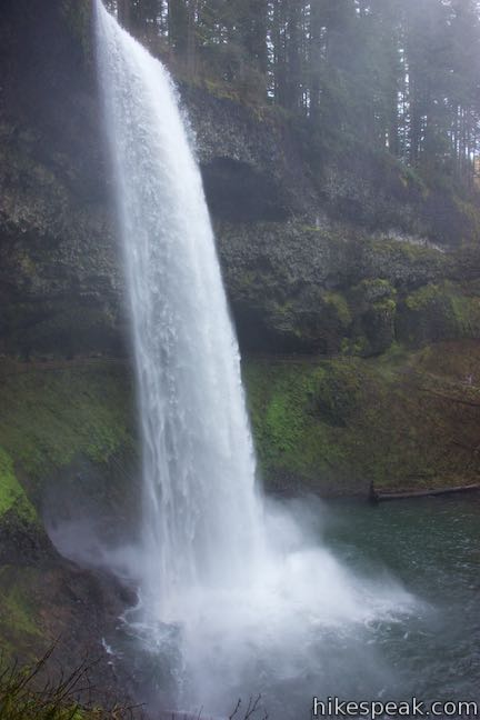
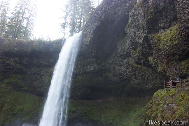
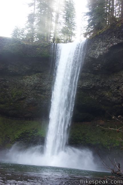
Turn left and get clear views of South Falls, which takes a dramatic drop from a basalt overhang.
Are you really going to hike right behind this colossal 177-foot tall mass of water? Yes.
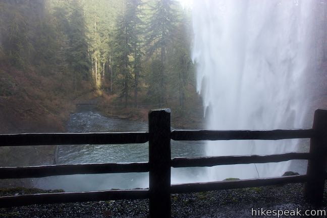
The trail somehow finds safe passage across ledges in the area behind the waterfall. Be prepared for spray from the waterfall to saturate you as you pass along the back of the opening behind South Falls. This awesome hiking experience offers unique waterfall views.
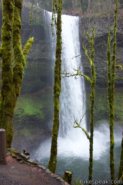
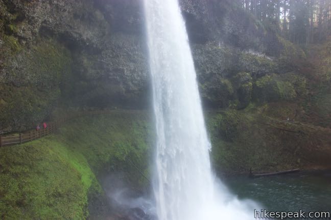
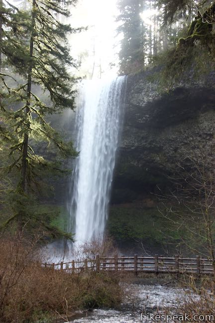
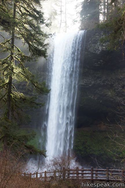
Come around the far side of South Falls, admiring its plunging water from yet another angle. Proceed down the west side of the canyon. Waterfall views persist as you approach a junction by a bridge over the creek, 0.6 miles from the trailhead. Pause here to admire South Falls from the elegant span. Canyon Trail continues down the South Fork of Silver Creek toward Lower South Falls (which is 2/3 of a mile away and also has a trail behind it), the next waterfall on Trail of Ten Falls Loop. If you’re interested in seeing Lower South Falls, but don’t have time for the full Trail of Ten Falls Loop, consider hiking the 2.8-mile Maple Ridge Loop. If one waterfall is all you plan to see, bear right and cross the bridge to finish out the South Falls Loop.
On the other side, the trail ascends through forest for 1/8 of a mile, taking one switchback to return to the junction on the side of the canyon where the loop began. Turn left and follow the trail back up to the top of the cliffs. Hike back the way you came, bearing right at the Stone Circle Junction to walk past South Falls Lodge and return to the trailhead.
The turn-by-turn directions for this hike are:
- Leave South Falls Trailhead (0 miles)
- Hike past South Falls Lodge to the Stone Circle Junction and turn left on Canyon Trail (0.15 miles)
- Bear left past the top of Maple Ridge Trail (0.2 miles)
- Look over the brink from South Falls Viewpoint and proceed down Canyon Trail to the right (0.25 miles)
- Bear left on the trail behind South Falls (0.45 miles)
- Turn right across a bridge below South Falls (0.6 miles)
- Turn left to ascend away from South Falls (0.73 miles)
- Stay to the left past South Falls Viewpoint (0.89 miles)
- Return to Stone Circle Junction and turn right toward the lodge and trailhead (0.95 miles)
- Return to the trailhead (1.1 miles)
Dogs and bikes are not allowed on this hike. Silver Falls State Park charges a fee to park at the trailhead, which is $5 per vehicle for the day or $30 for an annual Oregon State Parks pass. Silver Falls State Park is located in Marion County, Oregon, about 25 miles from Salem. No permit is needed to hike to South Falls, so get out and enjoy!
Directions to the Trailhead
- Take Interstate 5 to exit 253 for Route 22 & 99E, following signs for Detroit Lake & Bend.
- (The exit is about 45 miles south of Portland.)
- Head east from the end of the offramp on Route 22 (99E).
- Drive 5 miles and take exit 7, which has a sign for Route 214 and Silver Falls State Park.
- At the end of the offramp, turn left onto Route 214.
- Follow Route 214 through several intersections for 16 miles and then turn left, following a sign for South Falls.
- Now within the park, you'll make another left to reach the trailhead parking area.
Trailhead Location
Trailhead address: 20024 Silver Falls Hwy SE, Sublimity, OR 97385
Trailhead coordinates: 44.8776, -122.6556 (44° 52′ 39.4″N 122° 39′ 20.2″W)
View Silver Falls State Park in a larger map
Or view a regional map of surrounding Oregon trails and campgrounds.


 | Maple Ridge Loop This 2.8-mile hike in Silver Falls State Park ventures behind both South Falls and Lower South Falls and also explores a ridge-top forest. |
 | Trail of Ten Falls This 7.9-mile loop passes ten acclaimed waterfalls in Silver Falls State Park for a picturesque and exciting hike that actually goes behind four of the waterfalls. |
 | Spencer Butte This 5.2-mile hike crosses a fern-covered forest to panoramic views from the crown of Spencer Butte. |
 | Terwilliger Hot Springs This 0.9-mile hike leads to a natural hot springs in Willamette National Forest where bathers can soak in a series of terraced pools. |
 | Trails in Oregon Explore more hikes throughout the state of Oregon. |
Common Questions about South Falls in Silver Falls State Park
- Is the trail open?
- Yes. You should expect to find that South Falls Loop is open. There are no recent reports of trail closures. If you discover that the trail is closed, please help your fellow hikers by reporting a closure.
- Do I need a permit for this hike?
- Yes. State Park Day Use Fee.
- How much time does this hike take?
- It takes approximately 30 minutes to hike South Falls Loop. Individual hiking times vary. Add extra time for breaks and taking in the views.
- How long is this hike?
- The hike to South Falls Loop is a 1.1 mile lollipop loop with 200 feet of elevation change.
- Are dogs allowed on this trail?
- No, dogs are likely not allowed on South Falls Loop. The trail is primarily open to hikers.
- Is South Falls Loop good for kids?
- Yes, this hike is likely suitable for children. It is relatively short (1.1 miles) with manageable elevation gain.
- Will I see a waterfall on this hike?
- Yes, South Falls Loop features a waterfall.
- Where is the trailhead located?
- The trailhead for South Falls Loop is located in Sublimity, Oregon.
Trailhead Address:
20024 Silver Falls Hwy SE
Sublimity, Oregon 97385
Trailhead Coordinates:
44.8776, -122.6556 - What are the driving directions to the start of the hike?
To get to the trailhead: Take Interstate 5 to exit 253 for Route 22 & 99E, following signs for Detroit Lake & Bend. (The exit is about 45 miles south of Portland.) Head east from the end of the offramp on Route 22 (99E). Drive 5 miles and take exit 7, which has a sign for Route 214 and Silver Falls State Park. At the end of the offramp, turn left onto Route 214. Follow Route 214 through several intersections for 16 miles and then turn left, following a sign for South Falls. Now within the park, you'll make another left to reach the trailhead parking area.
View custom Google Maps directions from your current location.
- Are there other trails near South Falls Loop?
- Yes, you can find other nearby hikes using the Hikespeak Hike Finder Map.

I understand there is a wheelchair accessible view of Silver Falls. Is there any path or opportunity for those in wheelchairs to see other falls or is this it? I realize bathrooms, parking lots and gift shops are accessible, but disabled visitors like to explore too.
The trail to the viewpoint at the top of South Falls is made of pavement and brick and is wheelchair-friendly. The South Falls Historic District can also be explored by wheelchair. Unfortunately, I don’t believe it is possible to see any of the other waterfalls without the use of dirt trails. I’m not certain, but the trail to Upper North Falls might be level enough to attempt with a wheelchair. Enjoy your visit.
[…] South Falls is found along the Trail of Ten Falls in Silver Falls State Park […]