Hikes in Sierra National Forest
Sierra National Forest protects over 1.3 million acres in the heart of the Sierra Nevada Mountains (or more specifically on the west side of the Sierra between Yosemite National Park and Kings Canyon National Park). At elevations ranging from as low as 900 feet to just under 14,000 feet, the forest has a variety of environments, including tranquil sequoia groves and dramatic High Sierra scenery.
The park has numerous campgrounds, hiking trails, and other opportunities for outdoor recreation. Explore the outings listed below, or visit the Sierra National Forest Recreation Page for more inspiration, and to find a conditions report for the campgrounds, trailheads, and other sites. When the national parks get slammed with visitors, Sierra National Forest still offers solitude.
Closure Notice: The Nelder Grove area of Sierra National Forest was closed because of the Railroad Fire in the fall of 2017. Some areas remain closed. Check the status before visiting.
Highlights of Sierra National Forest


Sierra National Forest Hiking
This collection of trails in the Sierra National Forest lists hikes from north to south. The table may also be sorted alphabetically or by distance to help you pick your next hike. Each trail links to its own report complete with photos, maps, directions, and all the other information needed to locate and enjoy these trails. An interpretive map is also provided.
Trail | Description | Distance | Location |
|---|---|---|---|
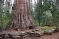 400 400 | Bull Buck Tree Trail This easy loop leaves from Nelder Grove Campground and leads to a single giant sequoia with an incredibly broad base. | 0.8 miles 120 feet | 37.4301, -119.5831 |
 410 410 | Big Ed Tree Trail This hike is quite short, but visits a tree that is quite big - part of the Nelder Grove of Giant Sequoias in Sierra National Forest. | 0.2 miles 25 feet | 37.4296, -119.58614 |
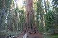
 420 420 | Shadow of the Giants Trail This nature trail loop visits giants sequoias and imparts wisdom about the great trees and their surroundings. | 1.1 miles 200 feet | 37.4262, -119.5962 |
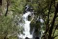 430 430 | Lewis Creek Trail to Corlieu Falls This hike passes down along a rushing creek to a viewing platform in front of an enthusiastic, cascading waterfall. | 0.8 miles 275 feet | 37.41662, -119.6266 |
 440 440 | Way of the Mono Trail This interpretive trail rises to a granite perch with grand views over Bass Lake and the surrounding Sierra. | 0.6 miles 140 feet | 37.3219, -119.5781 |
Sierra National Forest Camping
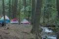 | Nelder Grove Campground This 7-site campground offers cozy nights in a partially logged grove of giant sequoias. |
Or explore hikes around Sequoia National Forest on the Hike Finder Map