Fountain Paint Pot Trail in Yellowstone National Park
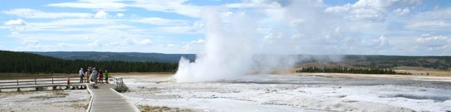
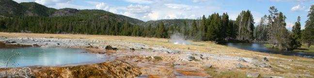
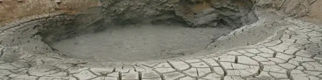
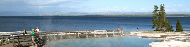
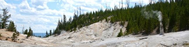
Yellowstone National Park has several hydrothermal areas, so what makes the Fountain Paint Pot Area worth visiting? For starters, this part of Lower Geyser Basin has all four of the hydrothermal features found in the park (mudpots, geysers, hot springs, and fumaroles) and you can see them all from a compact half-mile long boardwalk loop. While none of the many Fountain Paint Pot Area geysers are as famous as Old Faithful, they erupt so frequently that you are almost guaranteed a great show on your short hike. ...Read more.
Distance: 0.5 miles · Elevation change: 50 feet
By: Published: August 28, 2012 Last updated: April 9, 2026
Midway Geyser Basin in Yellowstone National Park
If you subscribe to the mantra go big or go home, do not leave Yellowstone without visiting Midway Geyser Basin. The main attraction on this 0.8-mile boardwalk is Grand Prismatic Spring, the largest hot spring in Yellowstone National Park. The easy loop also passes Excelsior Geyser, a steaming pool of vibrant blue water that isn't far behind in the contest over surface area. ...Read more.
Distance: 0.8 miles · Elevation change: 75 feet
By: Published: August 27, 2012 Last updated: April 6, 2026
Biscuit Basin in Yellowstone National Park
Biscuit Basin Loop offers a 2/3 of a mile lollipop-loop hike in Yellowstone National Park's Upper Geyser Basin. Even through the boardwalk is short, there are plenty of hydrothermal features to see. Highlights include colorful hot springs and spurting geysers like Black Opal Pool, Sapphire Pool, Jewel Geyser, Shell Spring, Avoca Spring, Mustard Spring, and Black Pearl Geyser. ...Read more.
Distance: 0.65 miles · Elevation change: 50 feet
By: Published: August 26, 2012 Last updated: April 9, 2026
Lamar Valley in Yellowstone National Park
No other destination in Yellowstone gives you a greater opportunity to see wild bison than Lamar Valley. The Lamar River feeds a wide grassy valley, drawing the massive grazers to the northeast corner of Yellowstone National Park. Route 212 (Northeast Entrance Road) runs down the valley past numerous viewpoints where you are almost guaranteed a sighting of the Lamar Valley Bison Herd. ...Read more.
By: Published: August 24, 2012 Last updated: April 8, 2026
Pebble Creek Trail in Yellowstone National Park
Starting just inside Yellowstone's northeast entrance near Cooke City, Montana, there is an interstate trail traveling through a beautiful backcountry meadow boxed in by 10,000-foot peaks. Pebble Creek Trail is often ventured as a top-to-bottom 12-mile long through hike ending at Pebble Creek Campground. There are five trail camps along Pebble Creek Trail for backpackers. ...Read more.
Distance: 12 miles · Elevation change: 950 feet
By: Published: August 23, 2012 Last updated: April 9, 2026
Mud Volcano Area in Yellowstone National Park
When explorers first discovered Mud Volcano in the 19th century, the rumbling eruptions could be heard half a mile away. Mud Volcano shook the ground and flung mud into the treetops. The volcano later blew itself apart and is not as active for today's visitors to Yellowstone National Park. Fortunately, Mud the Volcano Area still has several interesting hydrothermal features to witness. ...Read more.
Distance: 0.85 miles · Elevation change: 100 feet
By: Published: August 21, 2012 Last updated: April 17, 2026
Calcite Springs Overlook in Yellowstone National Park
When you drive by an overlook in Yellowstone National Park, it pays to stop. A short walk from a turnout on Grand Loop Road just north of Tower Fall brings travelers to Calcite Springs Overlook, perched on a bluff above the narrowest section of the Grand Canyon of Yellowstone. The mesmerizing northward view puts a rugged section of the Yellowstone River on display, accented by bleached cliffs and steam venting hydrothermal springs. ...Read more.
Distance: 0.25 miles · Elevation change: 25 feet
By: Published: August 19, 2012 Last updated: April 13, 2026
Tower Fall in Yellowstone National Park
Tower Fall drops 132 feet down Tower Creek just before the creek converges with the Yellowstone River. A hellish collection of towering volcanic spires surrounding the creek gives Tower Fall its name. There is an excellent view of Tower Fall from an easy-to-reach roadside overlook. A 1-mile round trip hike drops down to the Yellowstone River alongside Tower Creek and previously connected to a viewing platform at the base of the falls. ...Read more.
Distance: 1 mile · Elevation change: 225 feet
By: Published: August 18, 2012 Last updated: April 9, 2026
West Thumb Geyser Basin in Yellowstone National Park
There are several hydrothermal areas in Yellowstone National Park. West Thumb Geyser Basin stands out because it is on the edge of, and partially submerged by, Yellowstone Lake, which creates a dramatic backdrop for the dynamic geysers, pools, and springs. A dirt trail and wooden boardwalk loops through the geyser basin, offering a 2/3 of a mile long wheelchair-friendly stroll. ...Read more.
Distance: 0.65 miles · Elevation change: 25 feet
By: Published: August 16, 2012 Last updated: April 8, 2026
Monument Geyser Basin in Yellowstone National Park
Monument Geyser Basin is an active hydrothermal area that most visitors to Yellowstone National Park won't get to see. That's because most visitors won't pursue the 2.8-mile round trip hike required to reach the basin. There is 700 feet of elevation gain standing in the way, as the trail climbs a pine-covered mountainside with views of Mount Holmes and a snaking section of the Gibbon River. ...Read more.
Tagged with · Hydrothermal · National Parks
Distance: 2.8 miles · Elevation change: 700 feet
By: Published: August 14, 2012 Last updated: April 9, 2026