Coyote Wall Hike Columbia River Gorge National Scenic Area Little Maui Trail Little Moab Trail Coyote Wall Trail Washington
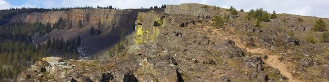
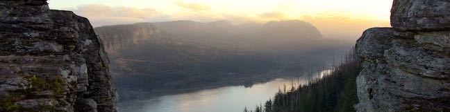
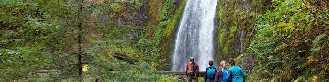
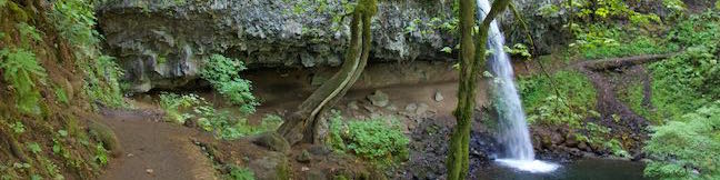
Take a drive through the Columbia River Gorge and you're sure to be impressed by a diagonal band of cliffs on the Washington side of the gorge that rise from the river toward the mountains above. These grand and daunting cliffs are called Coyote Wall or the Syncline. A network of single-track trails and old jeep roads extend up alongside the columnar basalt ledge. ...Read more.
My Hikes: Completed hikeA green icon of shows a picture of a landscape with a check mark in the upper right corner, signifying that this is a hike you would like to put on your completed list.OK! Add to trails I've hiked
My Hikes: Want to hikeA green icon of shows a picture of a landscape with a heart in the upper right corner, signifying that this is a hike you would like to put on your to-do list.OK! Add to trails I want to hike
TagsA green icon depicting a tags represents a list of words and phrases that this content is tagged with Tagged with · Cascade Range · Columbia River Gorge National Scenic Area · Free Trails · White Salmon
Hike DistanceA green icon of a hiker used to label information about the length of the hike Distance: 5.8 miles · Elevation change: 1575 feet
By: Published: Last updated: December 5, 2025
Camping in Beacon Rock State Park Main Campground Columbia River Gorge Washington
Tucked into the Washington side of the Columbia River Gorge, Beacon Rock State Park has great places camp and kick back after a day of traveling in the gorge or hiking Hamilton Mountain and Beacon Rock. Main Campground In the forest up the road from Hamilton Mountain Trailhead, you'll find the park's main campground spread around a single loop. A mossy ledge of basalt rises over one side of the campground. ...Read more.
TagsA green icon depicting a tags represents a list of words and phrases that this content is tagged with Tagged with · Beacon Rock State Park · Cascade Range · Stevenson · Tent Camping · Washington State Parks
By: Published: Last updated: May 13, 2025
Hamilton Mountain Trail Beacon Rock State Park Hike Washington Columbia River Gorge Pool of the Winds Rodney Falls Hike Hamilton Mountain Loop
Only hike Hamilton Mountain Trail if you like charming forests, bold waterfalls, and awesome cliff-top views. Hamilton Mountain Trail passes a viewpoint for the Pool of the Winds, where Rodney Falls plunges into a rock-wrapped punchbowl. The trail rises to a summit along the Columbia River Gorge, ascending 2,025 feet on a 7.75-mile lollipop loop. Some of Hamilton Mountain's best views come from a perch below the summit and a saddle after the summit. ...Read more.
My Hikes: Completed hikeA green icon of shows a picture of a landscape with a check mark in the upper right corner, signifying that this is a hike you would like to put on your completed list.OK! Add to trails I've hiked
My Hikes: Want to hikeA green icon of shows a picture of a landscape with a heart in the upper right corner, signifying that this is a hike you would like to put on your to-do list.OK! Add to trails I want to hike
TagsA green icon depicting a tags represents a list of words and phrases that this content is tagged with Tagged with · Beacon Rock State Park · Cascade Range · Stevenson · Summits · Washington State Parks · Waterfalls
Hike DistanceA green icon of a hiker used to label information about the length of the hike Distance: 7.75 miles · Elevation change: 2025 feet
By: Published: Last updated: December 6, 2025
Beacon Rock Trail Beacon Rock State Park Hike Washington Columbia River Gorge
Beacon Rock rises like a stone tower with sheer cliffs dropping to the Columbia River. Beacon Rock Trail could be the Columbia River Gorge relative of Moro Rock Trail in Sequoia National Park. The trail is built right up the side of the basalt monolith, using over fifty switchbacks and at least a dozen cliff-straddling bridges to reach a pointed summit. ...Read more.
My Hikes: Completed hikeA green icon of shows a picture of a landscape with a check mark in the upper right corner, signifying that this is a hike you would like to put on your completed list.OK! Add to trails I've hiked
My Hikes: Want to hikeA green icon of shows a picture of a landscape with a heart in the upper right corner, signifying that this is a hike you would like to put on your to-do list.OK! Add to trails I want to hike
TagsA green icon depicting a tags represents a list of words and phrases that this content is tagged with Tagged with · Beacon Rock State Park · Cascade Range · Stevenson · Summits · Washington State Parks
Hike DistanceA green icon of a hiker used to label information about the length of the hike Distance: 1.6 miles · Elevation change: 600 feet
By: Published: Last updated: December 6, 2025
Vista House Columbia River Gorge Crown Point Scenic Corridor Columbia Gorge Oregon
Vista House is a roadside viewpoint like no other. The beautifully designed and maintained building is an Oregon icon designated as a National Natural Landmark. The viewing deck that wraps around Vista House offers one of the greatest non-hike-dependent views in Oregon. Vista House resides on the inside of a bend in Historic Columbia River Highway on Crown Point, a lofty landing of basaltic rock at the west end of Columbia River Gorge. ...Read more.
TagsA green icon depicting a tags represents a list of words and phrases that this content is tagged with Tagged with · Cascade Range · Columbia River Gorge · Corbett · Oregon State Parks
By: Published: Last updated: July 18, 2025
Angel's Rest Trail Angel's Rest Hike Columbia River Gorge Angel's Rest Lookout Oregon Angels Rest Trail
Angel's Rest Lookout boast soaring views across Columbia River Gorge. Things get particularly heavenly at sunrise when the first rays of light grace the gorge. Angel's Rest Trail starts from Historic Columbia River Highway, just off Interstate 84, and rises 1,500 feet over a 4.8-mile round trip hike. In addition to superb sights at the top, the trail seals its Columbia River Gorge status by passing waterfalls on Coopey Creek. ...Read more.
My Hikes: Completed hikeA green icon of shows a picture of a landscape with a check mark in the upper right corner, signifying that this is a hike you would like to put on your completed list.OK! Add to trails I've hiked
My Hikes: Want to hikeA green icon of shows a picture of a landscape with a heart in the upper right corner, signifying that this is a hike you would like to put on your to-do list.OK! Add to trails I want to hike
TagsA green icon depicting a tags represents a list of words and phrases that this content is tagged with Tagged with · Cascade Range · Columbia River Gorge · Columbia River Gorge National Scenic Area · Free Trails · Waterfalls
Hike DistanceA green icon of a hiker used to label information about the length of the hike Distance: 4.8 miles · Elevation change: 1500 feet
By: Published: Last updated: December 5, 2025
Punchbowl Falls Hike Eagle Creek Trail Metlako Falls Viewpoint Columbia River Gorge National Scenic Area Oregon
Fantastic waterfalls, dramatic cliffs, charming cascades, and handsome forests entertain hikers on the first couple miles of Eagle Creek Trail. Venture up a scenic canyon on the Oregon side of the Columbia River Gorge near Cascade Locks, following the tumbling water of Eagle Creek. Trek under and across steep cliffs that place cascades in your path. ...Read more.
My Hikes: Completed hikeA green icon of shows a picture of a landscape with a check mark in the upper right corner, signifying that this is a hike you would like to put on your completed list.OK! Add to trails I've hiked
My Hikes: Want to hikeA green icon of shows a picture of a landscape with a heart in the upper right corner, signifying that this is a hike you would like to put on your to-do list.OK! Add to trails I want to hike
TagsA green icon depicting a tags represents a list of words and phrases that this content is tagged with Tagged with · Cascade Locks · Cascade Range · Columbia River Gorge National Scenic Area · Fish Hatchery · Waterfalls
Hike DistanceA green icon of a hiker used to label information about the length of the hike Distance: 4.55 miles · Elevation change: 400 feet
By: Published: Last updated: December 5, 2025
Mosier Twin Tunnels Hike Historic Columbia River Highway State Trail Columbia River Gorge Oregon
With its grand river and towering cliffs, the Columbia River Gorge is a tough place to build a roadway. See one of the engineering feats used to build a road through the gorge by moseying over to the Mosier Twin Tunnels. This picturesque pair of tunnels can be crossed on Historic Columbia River Highway State Trail, which follows the route of the century old road that crossed the gorge long before I-84. ...Read more.
My Hikes: Completed hikeA green icon of shows a picture of a landscape with a check mark in the upper right corner, signifying that this is a hike you would like to put on your completed list.OK! Add to trails I've hiked
My Hikes: Want to hikeA green icon of shows a picture of a landscape with a heart in the upper right corner, signifying that this is a hike you would like to put on your to-do list.OK! Add to trails I want to hike
TagsA green icon depicting a tags represents a list of words and phrases that this content is tagged with Tagged with · Cascade Range · Hood River · Mosier · Oregon State Parks
Hike DistanceA green icon of a hiker used to label information about the length of the hike Distance: 4.8 miles · Elevation change: 320 feet
By: Published: Last updated: December 5, 2025
Multnomah-Wahkeena Loop Columbia River Gorge National Scenic Area Oregon Multnomah Falls Larch Mountain Trail Wahkeena Trail Hike Wahkeena Falls Fairy Falls Ecola Falls Weisendanger Falls Waterfalls
Multnomah Falls is the tallest waterfall in Oregon and not the sort of waterfall that leaves you asking for more. Still, the Columbia River Gorge has so many waterfalls to offer that you can pair scoping out Multnomah Falls from top to bottom with admiring a quintet of other waterfalls on an immensely beautiful hike. This loop combines Wahkeena Trail with Larch Mountain Trail and is 6. ...Read more.
My Hikes: Completed hikeA green icon of shows a picture of a landscape with a check mark in the upper right corner, signifying that this is a hike you would like to put on your completed list.OK! Add to trails I've hiked
My Hikes: Want to hikeA green icon of shows a picture of a landscape with a heart in the upper right corner, signifying that this is a hike you would like to put on your to-do list.OK! Add to trails I want to hike
TagsA green icon depicting a tags represents a list of words and phrases that this content is tagged with Tagged with · Cascade Range · Columbia River Gorge National Scenic Area · Free Trails · Waterfalls
Hike DistanceA green icon of a hiker used to label information about the length of the hike Distance: 6.05 miles · Elevation change: 1525 feet
By: Published: Last updated: December 5, 2025
Horsetail Falls Trail – Oneonta Trail Loop Hike to Ponytail Falls Middle Oneonta Falls Columbia River Gorge National Scenic Area Oregon
Do you have a need for waterfalls? Heading to the Columbia River Gorge is a good start (the area is stocked full of them). If you choose to hike Horsetail Falls Trail, you'll get a tall waterfall right at the trailhead. Half a mile up the trail, you'll find another waterfall that you can actually walk behind. Combine Horsetail Falls Trail and Oneonta Trail for a 2. ...Read more.
My Hikes: Completed hikeA green icon of shows a picture of a landscape with a check mark in the upper right corner, signifying that this is a hike you would like to put on your completed list.OK! Add to trails I've hiked
My Hikes: Want to hikeA green icon of shows a picture of a landscape with a heart in the upper right corner, signifying that this is a hike you would like to put on your to-do list.OK! Add to trails I want to hike
TagsA green icon depicting a tags represents a list of words and phrases that this content is tagged with Tagged with · Cascade Range · Columbia River Gorge National Scenic Area · Free Trails · Waterfalls
Hike DistanceA green icon of a hiker used to label information about the length of the hike Distance: 2.85 miles · Elevation change: 325 feet
By: Published: Last updated: December 5, 2025