Shevlin Loop Trail Bend Oregon Hike Shevlin Park Tumalo Creek
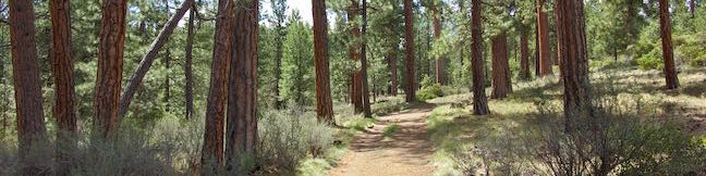
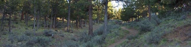
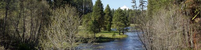
Shevlin Loop Trail explores pine forests along Tumalo Creek in Shevlin Park, which is just four miles west of downtown Bend. This pleasant woodland trail is mostly easy with a few rolling sections along the bluffs that border the creek. The loop is 4.75 miles long and explores much of Shevlin Park's 647 acres. The hike has 240 feet of elevation change and crosses lovely Tumalo Creek at two points. ...Read more.
My Hikes: Completed hikeA green icon of shows a picture of a landscape with a check mark in the upper right corner, signifying that this is a hike you would like to put on your completed list.OK! Add to trails I've hiked
My Hikes: Want to hikeA green icon of shows a picture of a landscape with a heart in the upper right corner, signifying that this is a hike you would like to put on your to-do list.OK! Add to trails I want to hike
TagsA green icon depicting a tags represents a list of words and phrases that this content is tagged with Tagged with · Bend · Cascade Range · Creeks · Free Trails · Shevlin Park · Tumalo Creek
Hike DistanceA green icon of a hiker used to label information about the length of the hike Distance: 4.75 miles · Elevation change: 240 feet
By: Published: Last updated: December 5, 2025
Archie Briggs Canyon Trail Bend Oregon Hike Deschutes River Trail Overlook
Archie Briggs Natural Area presents views over a dramatic stretch of the Deschutes River north of Bend. The river makes a sweeping curve beneath tall cliffs of volcanic rock and is backed by grand mountains like Black Butte and Mount Jefferson. Gaze down the canyon from atop cliffs on the south side of the curve in the river by an intersection of Deschutes River Trail and Archie Briggs Canyon Trail. ...Read more.
My Hikes: Completed hikeA green icon of shows a picture of a landscape with a check mark in the upper right corner, signifying that this is a hike you would like to put on your completed list.OK! Add to trails I've hiked
My Hikes: Want to hikeA green icon of shows a picture of a landscape with a heart in the upper right corner, signifying that this is a hike you would like to put on your to-do list.OK! Add to trails I want to hike
TagsA green icon depicting a tags represents a list of words and phrases that this content is tagged with Tagged with · Archie Briggs Natural Area · Awbrey Butte · Bend · Cascade Range · Deschutes River · Free Trails
Hike DistanceA green icon of a hiker used to label information about the length of the hike Distance: 1.25 miles · Elevation change: 325 feet
By: Published: Last updated: December 6, 2025
Pilot Butte Trail Bend Oregon Hike Pilot Butte Nature Trail Pilot Butte State Park
Pilot Butte is the biggest landmark in the city of Bend. This extinct cinder volcano is visible from almost everywhere in the city and its summit surpasses expectations with knock-out views of over Bend toward high desert landscapes and snowcapped Cascade Mountains. An extraordinary collection of mountains that includes Mount Hood, Mount Jefferson, Three Fingered Jack, the Three Sisters and Mount Bachelor are visible on clear days. ...Read more.
My Hikes: Completed hikeA green icon of shows a picture of a landscape with a check mark in the upper right corner, signifying that this is a hike you would like to put on your completed list.OK! Add to trails I've hiked
My Hikes: Want to hikeA green icon of shows a picture of a landscape with a heart in the upper right corner, signifying that this is a hike you would like to put on your to-do list.OK! Add to trails I want to hike
TagsA green icon depicting a tags represents a list of words and phrases that this content is tagged with Tagged with · Bend · Buttes · Free Trails · Pilot Butte State Park · Summits
Hike DistanceA green icon of a hiker used to label information about the length of the hike Distance: 1.8 miles · Elevation change: 475 feet
By: Published: Last updated: December 6, 2025
Head of the Metolius Springs Metolius River Headwaters Deschutes National Forest Central Oregon Hike
Gaze north from the observation site at the end of Head of the Metolius Trail and you'll have a beautiful (if traditional) view of a river flowing through a pine forest toward Mount Jefferson. Look in the other direction to see something surprising. The river springs to live all at once from a gushing source. The trail to Head of the Metolius in Deschutes National Forest is a quarter mile long and paved. ...Read more.
My Hikes: Completed hikeA green icon of shows a picture of a landscape with a check mark in the upper right corner, signifying that this is a hike you would like to put on your completed list.OK! Add to trails I've hiked
My Hikes: Want to hikeA green icon of shows a picture of a landscape with a heart in the upper right corner, signifying that this is a hike you would like to put on your to-do list.OK! Add to trails I want to hike
TagsA green icon depicting a tags represents a list of words and phrases that this content is tagged with Tagged with · Camp Sherman · Cascade Range · Deschutes National Forest · Free Trails · Sisters
Hike DistanceA green icon of a hiker used to label information about the length of the hike Distance: 0.5 miles · Elevation change: 35 feet
By: Published: Last updated: December 5, 2025