Wooded Gully Campground Mount Thomas Forest Conservation Area Campsite Wooded Gully Camping Area
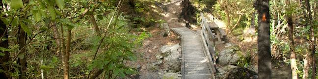
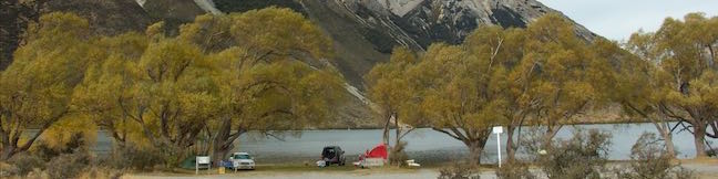
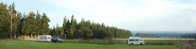
Wooded Gully is the campground in Mount Thomas Forest Conservation Area, an over 100-square-kilometer park in the foothills of the Southern Alps in the Canterbury Region of New Zealand. The campground is an hour's drive from Christchurch and right at the start of hiking tracks into the forest. The inexpensive campground is short on amenities, but does have nice sites in a grass field and along a stream that tent and campervan campers can enjoy. ...Read more.
TagsA green icon depicting a tags represents a list of words and phrases that this content is tagged with Tagged with · Campervan Camping · Mount Thomas Forest Conservation Area · New Zealand Department of Conservation · Okuku · Tent Camping
By: Published: Last updated: January 16, 2018
Kereru Loop Hike Mt Thomas Forest Wooded Gully Track Kereru Track Red Pine Track Mount Thomas Forest Conservation Area New Zealand
The shortest hike in Mount Thomas Forest is Kereru Loop, a 2.45 kilometer (1.5-mile) circuit that starts from Wooded Gully Campground. The loop employs three trails, Wooded Gully Track, Kereru Track, and Red Pine Track, for a quick walk through the forest. The loop doesn't offer any grand vistas and is highlighted by picnic spot along Wooded Gully Stream. ...Read more.
My Hikes: Completed hikeA green icon of shows a picture of a landscape with a check mark in the upper right corner, signifying that this is a hike you would like to put on your completed list.OK! Add to trails I've hiked
My Hikes: Want to hikeA green icon of shows a picture of a landscape with a heart in the upper right corner, signifying that this is a hike you would like to put on your to-do list.OK! Add to trails I want to hike
TagsA green icon depicting a tags represents a list of words and phrases that this content is tagged with Tagged with · Creeks · Free Trails · Mount Thomas Forest Conservation Area · New Zealand Department of Conservation · Okuku
Hike DistanceA green icon of a hiker used to label information about the length of the hike Distance: 2.45 kilometers / 1.5 miles · Elevation change: 95 meters / 310 feet
By: Published: Last updated: December 5, 2025
Lake Pearson Moana Rua Wildlife Refuge Campsite Canterbury New Zealand Lake Pearson Campground
Lakeside camping rarely comes free, so campers at Lake Pearson / Moana Rua Wildlife Refuge are right to feel lucky. Lake Pearson (Moana Rua) Campground is spread along the shore at the northwest end of a tranquil hourglass-shaped lake in a mountainous part of Canterbury on the South Island of New Zealand. State Highway 73 passes right alongside the lake and the free campground and picnic area are a convenient stop for travelers, just over 30 kilometers from Arthur's Pass National Park. ...Read more.
TagsA green icon depicting a tags represents a list of words and phrases that this content is tagged with Tagged with · Campervan Camping · New Zealand Department of Conservation · Tent Camping
By: Published: Last updated: January 7, 2019
Kura Tawhiti Castle Hill Conservation Area Hike New Zealand Canterbury
Not far from Arthur's Pass National Park in the Canterbury Region of New Zealand, you'll come across an alluring playground of limestone boulders in Kura Tawhiti / Castle Hill Conservation Area. Mountain climbers have fun scaling its many misshapen boulders and hikers will enjoy venturing through the area as well. A level 600-meter long track leads to the foot of a grassy hill covered with a crown of misshapen rocks. ...Read more.
My Hikes: Completed hikeA green icon of shows a picture of a landscape with a check mark in the upper right corner, signifying that this is a hike you would like to put on your completed list.OK! Add to trails I've hiked
My Hikes: Want to hikeA green icon of shows a picture of a landscape with a heart in the upper right corner, signifying that this is a hike you would like to put on your to-do list.OK! Add to trails I want to hike
TagsA green icon depicting a tags represents a list of words and phrases that this content is tagged with Tagged with · Bouldering · Castle Hill · Free Trails · Kura Tawhiti / Castle Hill Conservation Area · Memorials · New Zealand Department of Conservation
Hike DistanceA green icon of a hiker used to label information about the length of the hike Distance: 2.6 kilometers / 1.6 miles · Elevation change: 65 meters / 215 feet
By: Published: Last updated: December 5, 2025
Mount Ollivier from Mueller Hut Aoraki Mount Cook National Park Southern Alps Summit New Zealand
Mount Ollivier is a 1,933-meter tall peak in the Sealy Range of the Southern Alps in Aoraki Mount Cook National Park. In 1939, Sir Edmond Hillary summited the mountain in what is recognized as his first major climb. (He went on to bag some other noteworthy peaks as well...) To get to the top of Mount Ollivier, you will first need to make your way to Mueller Hut, which is accomplished by trekking up Sealy Tarns Track and Mueller Hut Route, gaining 1,045 meters over 5. ...Read more.
My Hikes: Completed hikeA green icon of shows a picture of a landscape with a check mark in the upper right corner, signifying that this is a hike you would like to put on your completed list.OK! Add to trails I've hiked
My Hikes: Want to hikeA green icon of shows a picture of a landscape with a heart in the upper right corner, signifying that this is a hike you would like to put on your to-do list.OK! Add to trails I want to hike
TagsA green icon depicting a tags represents a list of words and phrases that this content is tagged with Tagged with · Mount Cook · New Zealand Department of Conservation · New Zealand National Parks · Off Trail · Summits · Aoraki Mount Cook National Park
Hike DistanceA green icon of a hiker used to label information about the length of the hike Distance: 1.2 kilometers / 0.75 miles · Elevation change: 125 meters / 410 feet
By: Published: Last updated: December 5, 2025
Mueller Hut Route Aoraki Mount Cook National Park Viewpoint Mueller Hut Climb Southern Alps Hike New Zealand Sealy Range
Mueller Hut is one of the most spectacular destinations for a day hike or overnight trek in Aoraki Mount Cook National Park (and perhaps all of New Zealand). Reaching the hut is no simple walk in the park, demanding an ascent of over one thousand meters in just over five kilometers. They truly don't come much steeper than this and that challenge is part of the trek's appeal. ...Read more.
My Hikes: Completed hikeA green icon of shows a picture of a landscape with a check mark in the upper right corner, signifying that this is a hike you would like to put on your completed list.OK! Add to trails I've hiked
My Hikes: Want to hikeA green icon of shows a picture of a landscape with a heart in the upper right corner, signifying that this is a hike you would like to put on your to-do list.OK! Add to trails I want to hike
TagsA green icon depicting a tags represents a list of words and phrases that this content is tagged with Tagged with · Huts · Mount Cook · New Zealand Department of Conservation · New Zealand National Parks · Southern Alps · Aoraki Mount Cook National Park
Hike DistanceA green icon of a hiker used to label information about the length of the hike Distance: 10.5 kilometers / 6.5 miles · Elevation change: 1045 meters / 3425 feet
By: Published: Last updated: December 5, 2025
Sealy Tarns Track Aoraki Mount Cook National Park Sealy Tarns Stairway Walk Southern Alps Mt Cook Hike New Zealand Walk
In a park full of massive features, it might surprise you to learn that a couple small ponds are a premier hiking destination. The Sealy Tarns are located 500 meters up a steep mountainside, with mirror-like water that can reflect nearby mountains like Mount Sefton and Mount Cook. Sealy Tarns Track is not very long, but it is very steep, coming it at 5. ...Read more.
My Hikes: Completed hikeA green icon of shows a picture of a landscape with a check mark in the upper right corner, signifying that this is a hike you would like to put on your completed list.OK! Add to trails I've hiked
My Hikes: Want to hikeA green icon of shows a picture of a landscape with a heart in the upper right corner, signifying that this is a hike you would like to put on your to-do list.OK! Add to trails I want to hike
TagsA green icon depicting a tags represents a list of words and phrases that this content is tagged with Tagged with · Free Trails · Mount Cook · New Zealand Department of Conservation · New Zealand National Parks · Southern Alps · Aoraki Mount Cook National Park
Hike DistanceA green icon of a hiker used to label information about the length of the hike Distance: 5.8 kilometers / 3.6 miles · Elevation change: 547 meters / 1795 feet
By: Published: Last updated: December 5, 2025
Kea Point Track Aoraki Mount Cook National Park Viewpoint Southern Alps Hike New Zealand Walk
Kea Point offers a captivating vantage point from a perch above a glacier lake. Mighty Mount Sefton rises high in front of the viewpoint and Mount Cook is in sight as well. Kea Point can be reached from Mount Cook Village for a two-hour outing and you can cut that time in half by beginning from a car park next to White Horse Hill Campground for a three-kilometer round trip hike with 95 meters of elevation change (or 1. ...Read more.
My Hikes: Completed hikeA green icon of shows a picture of a landscape with a check mark in the upper right corner, signifying that this is a hike you would like to put on your completed list.OK! Add to trails I've hiked
My Hikes: Want to hikeA green icon of shows a picture of a landscape with a heart in the upper right corner, signifying that this is a hike you would like to put on your to-do list.OK! Add to trails I want to hike
TagsA green icon depicting a tags represents a list of words and phrases that this content is tagged with Tagged with · Free Trails · Glacier Lakes · Mount Cook · New Zealand Department of Conservation · New Zealand National Parks · Aoraki Mount Cook National Park
Hike DistanceA green icon of a hiker used to label information about the length of the hike Distance: 3 kilometers / 1.85 miles · Elevation change: 95 meters / 310 feet
By: Published: Last updated: December 5, 2025
Hooker Valley Track Aoraki Mount Cook National Park Hike New Zealand Walk to Hooker Glacier Lake
Hooker Valley Track is among the most popular walking tracks in Aoraki Mount Cook National Park and the reasons why are obvious. This 11-kilometer (6.8-mile) round trip hike has non-stop mountain views and the destination is incredible. The track ends at the edge of Hooker Lake, where you can watch icebergs that were set adrift from Hooker Glacier, glide across the water below Aoraki/Mount Cook, the tallest mountain in the Southern Alps. ...Read more.
My Hikes: Completed hikeA green icon of shows a picture of a landscape with a check mark in the upper right corner, signifying that this is a hike you would like to put on your completed list.OK! Add to trails I've hiked
My Hikes: Want to hikeA green icon of shows a picture of a landscape with a heart in the upper right corner, signifying that this is a hike you would like to put on your to-do list.OK! Add to trails I want to hike
TagsA green icon depicting a tags represents a list of words and phrases that this content is tagged with Tagged with · Free Trails · Glacier Lakes · Glaciers · Memorials · Mount Cook · New Zealand Department of Conservation · New Zealand National Parks · Aoraki Mount Cook National Park
Hike DistanceA green icon of a hiker used to label information about the length of the hike Distance: 11 kilometers / 6.8 miles · Elevation change: 120 meters / 400 feet
By: Published: Last updated: December 5, 2025
Tasman Glacier View Track Blue Lakes Track Aoraki Mount Cook National Park Hike New Zealand Walk
Two tracks are combined in Blue Lakes and Tasman Glacier View Walk for a 1.85-kilometer (1.15 mile) round trip outing, netting views of small pools and a big lake below New Zealand's largest glacier. This Tasman Valley hike ascends rocky moraine to a viewpoint that looks down on a long, milky-colored lake below Tasman Glacier and several peaks in the Southern Alps. ...Read more.
My Hikes: Completed hikeA green icon of shows a picture of a landscape with a check mark in the upper right corner, signifying that this is a hike you would like to put on your completed list.OK! Add to trails I've hiked
My Hikes: Want to hikeA green icon of shows a picture of a landscape with a heart in the upper right corner, signifying that this is a hike you would like to put on your to-do list.OK! Add to trails I want to hike
TagsA green icon depicting a tags represents a list of words and phrases that this content is tagged with Tagged with · Free Trails · Glacier Lakes · Glaciers · Mount Cook · New Zealand Department of Conservation · New Zealand National Parks · Aoraki Mount Cook National Park
Hike DistanceA green icon of a hiker used to label information about the length of the hike Distance: 1.85 kilometers / 1.15 miles · Elevation change: 85 meters / 280 feet
By: Published: Last updated: December 5, 2025