Ernie Maxwell Scenic Trail in the San Jacinto Mountains
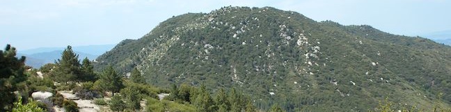
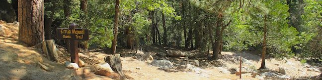
The San Jacinto Mountains are a steep rugged mountain range full of challenging trails that put hikers to the test... Ernie Maxwell Scenic Trail is not one of those trails. This leisurely alternative is 5.2 miles round trip with 675 rolling feet of elevation change. The gradual and enjoyable dirt single track overlooks the mountain community of Idyllwild and is appropriate for hikers of all abilities. ...Read more.
Distance: 5.2 miles · Elevation change: 675 feet
By: Published: July 3, 2013 Last updated: April 11, 2026
Indian Mountain in the San Jacinto Mountains
The 6-mile round trip hike to Indian Mountain starts from a convenient trailhead on Route 243, the main road between Banning and Idyllwild. While San Jacinto Peak is the blockbuster summit in the San Jacinto Mountains, this Indy is a crowd pleaser too, requiring a feature-length time commitment of two to three hours to hike to and from the 5,790-foot summit. ...Read more.
Distance: 6 miles · Elevation change: 815 feet
By: Published: July 1, 2013 Last updated: April 9, 2026
Observatory Trail in Cleveland National Forest
Within the Cleveland National Forest on Palomar Mountain is a trail through a pleasant woodland that has broad valley vistas en route to a world-renowned destination. What more could you want? Strap on your hiking boots and set out up Observatory Trail, which is 2.2 miles long from point to point with 700 feet of elevation gain. The trail starts at Observatory Campground and ends just outside the Palomar Observatory. ...Read more.
Distance: 5.1 miles · Elevation change: 700 feet
By: Published: April 3, 2013 Last updated: April 9, 2026
Observatory Campground in Cleveland National Forest
Observatory Campground is a 42-site campground in the Palomar Mountains near San Diego County's famed Palomar Observatory. The astronomically accommodating Cleveland National Forest campground is the start of Observatory Trail, which ascends to Palomar Observatory. Observatory Campground is open from April through October and is suitable for tents or RVs. ...Read more.
By: Published: April 3, 2013 Last updated: April 13, 2026
Indian Flats Trail to East Fork San Luis Rey River in Cleveland National Forest
Located in the Cleveland National Forest near Warner Springs, The live oak-shaded Atáxam Mámta'ash Campground (formerly know as Indian Flats) is the start of a short trail to a trickling river fork. It is a 0.5-mile round trip hike from the campground goes down to the East Fork of the San Luis Rey River, which flows down a mountain slope covered in granite boulders. ...Read more.
Distance: 0.5 miles · Elevation change: 75 feet
By: Published: April 2, 2013 Last updated: April 9, 2026
Atáxam Mámta’ash Campground (fka Indian Flats) in Cleveland National Forest
Atáxam Mámta'ash Campground is a small 17-site campground in the Cleveland National Forest near Warner Springs. The campground lies within a sunny live oak woodland at 3,600 feet. At this elevation, expect cool night and warm days. Atáxam Mámta'ash Campground, formerly known as Indian Flats Campground, is located below Hot Springs Mountain, the 6,533-foot high point of San Diego County. ...Read more.
By: Published: April 2, 2013 Last updated: April 13, 2026
Lake View Loop & East Ridge Overlook in Peters Canyon Regional Park
Peters Canyon Regional Park is an Orange County Park preserving 354 acres of open space including the 55-acre Peters Canyon Reservoir. A gradual 2.7-mile loop around the reservoir is popular trail with joggers and dog walkers. Other trails in the park allow visitors to hike even farther. The 5.7-mile East Ridge Loop is an expansion of the Lake View Loop that delivers a grand tour of the park. ...Read more.
Distance: 3.65 miles · Elevation change: 200 feet
By: Published: March 28, 2013 Last updated: December 5, 2025
Moro Beach in Crystal Cove State Park
Crystal Cove State Park has two main draws, the beach and the backcountry, so why not get a bit of both? The El Moro Visitor Center is the main trailhead for hikes into the backcountry (like Geology Discovery Trail), and it can also be the starting point of a 2-mile round trip hike to Moro Beach. This distance can easily be extended by exploring more of Moro Canyon and the surrounding ridges. ...Read more.
Distance: 2 miles · Elevation change: 150 feet
By: Published: February 27, 2013 Last updated: December 5, 2025
Geology Discovery Trail (Backcountry Loop) in Crystal Cove State Park
Crystal Cove State Park is one of Orange County's finest places to enjoy the outdoors. The park preserves 3.2 miles of coastline between Laguna Beach and Corona del Mar and 2,400 acres of backcountry wilderness (bordering Laguna Coast Wilderness Park). An excellent way to explore the coastal canyons and ridges in the backcountry of Crystal Cove State Park is to set out on Geology Discovery Trail, a 9-mile loop incorporating a few trails to highlight the park's rocky past. ...Read more.
Distance: 9 miles · Elevation change: 900 feet
By: Published: February 27, 2013 Last updated: December 6, 2025
Lake Huntington in Huntington Beach Central Park
To describe this hike, you have to use a couple phrases that you wouldn't normally associate with Orange County, Central Park and Lake Trail, but you will also use a few phrases that are quite fitting for Southern California, laid back and leisurely. Like the Big Apple, there is a Central Park in Huntington Beach (the Big Orange?) with over 350 acres of green space just a couple miles from the blue waters of the Pacific. ...Read more.
Distance: 0.75 miles · Elevation change: 25 feet
By: Published: February 23, 2013 Last updated: April 9, 2026