Columbia Rock Yosemite National Park Columbia Rock Viewpoint Yosemite Falls Trail Hike Yosemite Valley California
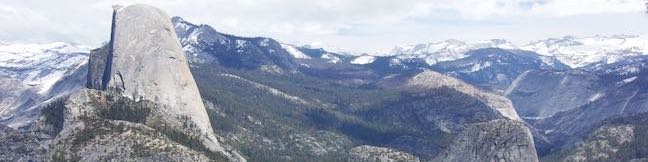
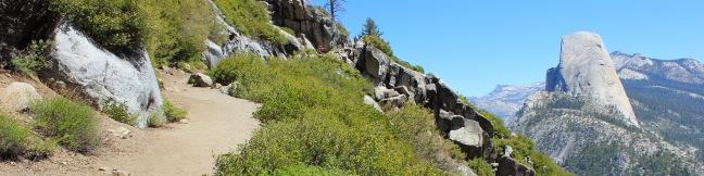
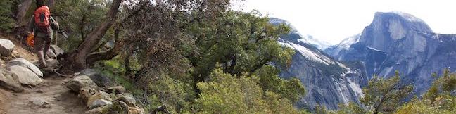
Yosemite Valley looks great from the bottom up, the top down, and even the middle out. For this neither-up-nor-down view over Yosemite Valley, visit Columbia Rock, a viewpoint on Yosemite Falls Trail perched about thousand feet up the north wall of Yosemite Valley. The hike from Camp 4 up to Columbia Rock is 2.2 miles round trip with 985 feet of elevation change. ...Read more.
My Hikes: Completed hikeA green icon of shows a picture of a landscape with a check mark in the upper right corner, signifying that this is a hike you would like to put on your completed list.OK! Add to trails I've hiked
My Hikes: Want to hikeA green icon of shows a picture of a landscape with a heart in the upper right corner, signifying that this is a hike you would like to put on your to-do list.OK! Add to trails I want to hike
TagsA green icon depicting a tags represents a list of words and phrases that this content is tagged with Tagged with · National Parks · Yosemite Valley
Hike DistanceA green icon of a hiker used to label information about the length of the hike Distance: 2.2 miles · Elevation change: 985 feet
By: Published: Last updated: December 5, 2025
Washburn Point Overlook Glacier Point Road Viewpoint Yosemite National Park California
Glacier Point is probably the most incredibly viewpoint in Yosemite National Park (rivaled closely by Tunnel View), but it isn't the only viewpoint along Glacier Point Road. Washburn Point is located 3/4 of a miles from the end of Glacier Point Road, south of Glacier Point. Its vistas are similar to Glacier Point, and since you have to pass Washburn Point to get out to Glacier Point, it's definitely worth stopping for this added perspective of great Yosemite landscapes. ...Read more.
TagsA green icon depicting a tags represents a list of words and phrases that this content is tagged with Tagged with · National Parks
By: Published: Last updated: April 26, 2019
Wildcat Falls Trail Yosemite National Park Wildcat Creek Falls Path Waterfall Hike California
Is it possible to have a Yosemite National Park waterfall all to yourself? Yes! The odds of waterfall solitude are pretty low when you go to Yosemite Falls, Bridalveil Fall, or Vernal Fall and Nevada Fall along the Mist Trail, but unheralded Wildcat Falls is different. Although this multi-tier waterfall is about 650 feet tall, only the bottom 50-foot tall cascade at the base of Wildcat Falls is visible on this hike, wrapped in vegetation that creates a private retreat. ...Read more.
My Hikes: Completed hikeA green icon of shows a picture of a landscape with a check mark in the upper right corner, signifying that this is a hike you would like to put on your completed list.OK! Add to trails I've hiked
My Hikes: Want to hikeA green icon of shows a picture of a landscape with a heart in the upper right corner, signifying that this is a hike you would like to put on your to-do list.OK! Add to trails I want to hike
TagsA green icon depicting a tags represents a list of words and phrases that this content is tagged with Tagged with · National Parks · Waterfalls
Hike DistanceA green icon of a hiker used to label information about the length of the hike Distance: 0.15 miles · Elevation change: 15 feet
By: Published: Last updated: December 5, 2025
Yosemite Falls Trail Yosemite National Park Upper Yosemite Fall Hike Yosemite Valley California
Yosemite Falls is incredibly beautiful and incredibly big. It is the tallest waterfall in North America, the 5th tallest waterfall in the world, and a star along the north wall of Yosemite Valley. Hiking to Yosemite Falls is one of the greatest things visitors can do in Yosemite National Park. Yosemite Falls drops a total of 2,425 feet, beginning with the cliff-leaping 1,430-foot Upper Fall. ...Read more.
My Hikes: Completed hikeA green icon of shows a picture of a landscape with a check mark in the upper right corner, signifying that this is a hike you would like to put on your completed list.OK! Add to trails I've hiked
My Hikes: Want to hikeA green icon of shows a picture of a landscape with a heart in the upper right corner, signifying that this is a hike you would like to put on your to-do list.OK! Add to trails I want to hike
TagsA green icon depicting a tags represents a list of words and phrases that this content is tagged with Tagged with · National Parks · Waterfalls · Yosemite Valley
Hike DistanceA green icon of a hiker used to label information about the length of the hike Distance: 7 miles · Elevation change: 2715 feet
By: Published: Last updated: December 5, 2025
Housekeeping Camp Yosemite National Park Lodging Accommodations Yosemite Valley California
Yosemite National Park receives four million visitors per year, filling the park's campgrounds and hotels. When all the campsites are reserved and the hotels have no vacancies (or list prices that are uncomfortably high), consider a middle option provided at Housekeeping Camp in the middle of Yosemite Valley. Housekeeping Camp offers 3-walled units with canvas roofs and flaps – imagine something that is not quite a room and not quite a tent. ...Read more.
TagsA green icon depicting a tags represents a list of words and phrases that this content is tagged with Tagged with · Accommodations · National Parks · Yosemite Valley
By: Published: Last updated: May 13, 2025
Happy Isles Trail Yosemite National Park The Happy Isles Merced River Hike Yosemite Valley California
Near the amazing hiking trails in Yosemite Valley is the designed-to-be-delightful Happy Isles Trail. The easy 3/4 of a mile walk at Happy Isles explores a pair of small islands in the Merced River at the east end of Yosemite Valley. While the trail doesn't feature a show-stopping attraction (like Lower Yosemite Fall Trail), the Happy Isles live up to their name – a pleasant and happy place to walk along the river. ...Read more.
My Hikes: Completed hikeA green icon of shows a picture of a landscape with a check mark in the upper right corner, signifying that this is a hike you would like to put on your completed list.OK! Add to trails I've hiked
My Hikes: Want to hikeA green icon of shows a picture of a landscape with a heart in the upper right corner, signifying that this is a hike you would like to put on your to-do list.OK! Add to trails I want to hike
TagsA green icon depicting a tags represents a list of words and phrases that this content is tagged with Tagged with · National Parks · Wheelchair-Friendly · Yosemite Valley
Hike DistanceA green icon of a hiker used to label information about the length of the hike Distance: 0.75 miles · Elevation change: 50 feet
By: Published: Last updated: December 5, 2025
Camp 4 Campground Yosemite National Park Walk-in Campground Yosemite Valley California Tent camping
Camp 4 is a historic campground in Yosemite National Park – and that's not even hyperbole; the campground is listed with the National Register of Historic Places "for its significant association with the history of modern rock climbing in America." Camp 4 has 35 shared walk-in tent campsites. While reservations need to be booked months in advance at other campgrounds in Yosemite Valley, Camp 4 is the exception, allowing reservations on a 7-day rolling basis, meaning that you can only book a site 7 days in advance. ...Read more.
TagsA green icon depicting a tags represents a list of words and phrases that this content is tagged with Tagged with · National Parks · Tent Camping · Yosemite Valley
By: Published: Last updated: September 3, 2024
Wawona Swinging Bridge Trail Yosemite National Park Bridge Hike South Fork Merced River Swimming Hole Wawona California
Swinging Bridge in Yosemite Valley seduces photographers with views of Yosemite Falls. This is not a hike to that bridge, which isn't actually a swinging suspension bridge. This is a hike to Wawona Swinging Bridge, which has plenty of bounce in it's step, spanning a boulder-framed chute in the South Fork Merced River. Wawona Swinging Bridge is located at the south end of Yosemite National Park, where it doubles as a swimming hole destination when temperatures are running high and the river is running low. ...Read more.
My Hikes: Completed hikeA green icon of shows a picture of a landscape with a check mark in the upper right corner, signifying that this is a hike you would like to put on your completed list.OK! Add to trails I've hiked
My Hikes: Want to hikeA green icon of shows a picture of a landscape with a heart in the upper right corner, signifying that this is a hike you would like to put on your to-do list.OK! Add to trails I want to hike
TagsA green icon depicting a tags represents a list of words and phrases that this content is tagged with Tagged with · National Parks · Swimming Holes · Wawona
Hike DistanceA green icon of a hiker used to label information about the length of the hike Distance: 0.7 miles · Elevation change: 70 feet
By: Published: Last updated: December 6, 2025
Wawona Meadow Loop Trail Yosemite National Park Wawona area day hike Wawona Hotel Walk Wawona Meadow Nature Trail
Wawona Meadow Loop Trail weaves through the forest surrounding a large meadow at the south end of Yosemite National Park, offering a relaxing hike that receives less attention than those in Yosemite Valley. Starting from trailheads on two sides of Wawona Hotel (Big Trees Lodge), Meadow Loop Trail follows an old road for 3.3 miles and can be connected by paths across the hotel ground for a 3. ...Read more.
My Hikes: Completed hikeA green icon of shows a picture of a landscape with a check mark in the upper right corner, signifying that this is a hike you would like to put on your completed list.OK! Add to trails I've hiked
My Hikes: Want to hikeA green icon of shows a picture of a landscape with a heart in the upper right corner, signifying that this is a hike you would like to put on your to-do list.OK! Add to trails I want to hike
TagsA green icon depicting a tags represents a list of words and phrases that this content is tagged with Tagged with · National Parks · Nature Trails · Wawona
Hike DistanceA green icon of a hiker used to label information about the length of the hike Distance: 3.9 miles · Elevation change: 250 feet
By: Published: Last updated: December 5, 2025
Panorama Trail Yosemite National Park
Panorama Trail is a nearly 10-mile long point-to-point hike from the top to the bottom of Yosemite Valley. Starting at Glacier Point and ending at Happy Isles, the trail descends 3,200 feet and is filled with sensational views. You could not pick a more panoramic start for Panorama Trail than Glacier Point, a spectacular drive-up overlook atop the south wall of Yosemite Valley. ...Read more.
My Hikes: Completed hikeA green icon of shows a picture of a landscape with a check mark in the upper right corner, signifying that this is a hike you would like to put on your completed list.OK! Add to trails I've hiked
My Hikes: Want to hikeA green icon of shows a picture of a landscape with a heart in the upper right corner, signifying that this is a hike you would like to put on your to-do list.OK! Add to trails I want to hike
TagsA green icon depicting a tags represents a list of words and phrases that this content is tagged with Tagged with · John Muir Trail · National Parks · Waterfalls · Yosemite Valley
Hike DistanceA green icon of a hiker used to label information about the length of the hike Distance: 10 miles · Elevation change: 3200 feet
By: Published: Last updated: December 5, 2025