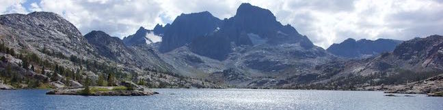
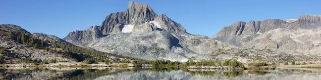
Garnet Lake Hike John Muir Trail Ansel Adams Wilderness Inyo National Forest Mammoth Lakes Eastern Sierra Nevada Mountains California
Garnet Lake is located on John Muir Trail between Shadow Lake and Thousand Island Lake in the Ansel Adams Wilderness of Inyo National Forest. The lake is stunning, set below the 12,936-foot mass of Banner Peak and framed by ridges of bedrock and pines. Hiking directly there, Garnet Lake is 8.55 miles from the trailhead at Agnew Meadows, so most of the lake's visitors are backpackers (a... Read more.
OK! Add to trails I’ve hiked
OK! Add to trails I want to hike
Tagged with · Ansel Adams Wilderness · John Muir Trail · Lakes · Mammoth Lakes
Distance: 5.65 miles · Elevation change: 1130 feet
By: Published: Last updated: August 29, 2019
Iceberg Lake Hike Ansel Adams Wilderness Inyo National Forest Mammoth Lakes Eastern Sierra Nevada Mountains California Iceberg Lake Trail from Ediza Lake
Cradled below a jagged ridge of volcanic peaks called the Minarets, Iceberg Lake is a beautiful, potentially snow-bordered or ice-filled lake of vivid blue water. The backcountry lake is located deep in the Ansel Adams Wilderness of Inyo National Forest, 8.3 miles from the trailhead at Agnew Meadows. Iceberg Lake is just a mile from Ediza Lake and a nice extension for the hike to that... Read more.
OK! Add to trails I’ve hiked
OK! Add to trails I want to hike
Tagged with · Ansel Adams Wilderness · Lakes · Mammoth Lakes
Distance: 2 miles · Elevation change: 510 feet
By: Published: Last updated: January 11, 2018
Ediza Lake Ansel Adams Wilderness Inyo National Forest Mammoth Lakes Eastern Sierra Nevada Mountains California Shadow Creek Trail Ediza Lake Hike
With high summit-reflecting waters, Ediza Lake is beautiful to behold. The lake is wrapped by meadows and trees and sports massive views of Mount Ritter and Banner Peak, making it a popular destination for hikers in the Ansel Adams Wilderness of Inyo National Forest. Starting from Agnew Meadows near Mammoth Lakes, Ediza Lake is reachable on a rewarding full day hike of over 14 miles round... Read more.
OK! Add to trails I’ve hiked
OK! Add to trails I want to hike
Tagged with · Ansel Adams Wilderness · Creeks · John Muir Trail · Lakes · Mammoth Lakes
Distance: 15 miles · Elevation change: 1250 feet
By: Published: Last updated: January 7, 2019
Shadow Lake Ansel Adams Wilderness Inyo National Forest Mammoth Lakes Eastern Sierra Nevada Mountains California Shadow Creek Trail River Trail
Get ready for Shadow Lake to step out of the shadows on this scenic hike in the Ansel Adams Wilderness of Inyo National Forest. Shadow Lake is a beautiful mountain lake on Shadow Creek Trail about halfway between the trailhead at Agnew Meadows and Ediza Lake, a popular destination for backpackers and folks committing to a day hike of over 14 miles. Shadow Lake is a worthwhile target on its... Read more.
OK! Add to trails I’ve hiked
OK! Add to trails I want to hike
Tagged with · Ansel Adams Wilderness · Creeks · John Muir Trail · Lakes · Mammoth Lakes · Pacific Crest Trail
Distance: 8.5 miles · Elevation change: 750 feet
By: Published: Last updated: September 11, 2019
Rainbow Falls Devils Postpile National Monument Mammoth Lakes Waterfall Hike Eastern Sierra Nevada Mountains California
While Devils Postpile Formation is the reason you come to Devils Postpile National Monument, you shouldn't leave without seeing Rainbow Falls, an attractive 101-foot single drop waterfall that leaps over volcanic cliffs and flashes frequent rainbows. Luckily for hikers, both attractions can be seen on the very same trek. Devils Postpile Formation is less than half a mile from the park's... Read more.
OK! Add to trails I’ve hiked
OK! Add to trails I want to hike
Tagged with · Mammoth Lakes · Waterfalls
Distance: 5.1 miles · Elevation change: 325 feet
By: Published: Last updated: April 6, 2017
Devils Postpile Trail Devils Postpile Formation Hike Devils Postpile National Monument Mammoth Lakes Eastern Sierra Nevada Mountains California
The main attraction in Devils Postpile National Monument is, of course, the Devils Postpile Formation, which has striking 60-foot tall cliffs of exposed columnar basalt. From the park's main trailhead, it is a 1-mile round trip hike to the base of Devils Postpile on a wheelchair-friendly route with 40 feet of elevation change. A second trail crosses the top of Devils Postpile and allows... Read more.
OK! Add to trails I’ve hiked
OK! Add to trails I want to hike
Tagged with · Mammoth Lakes
Distance: 1.35 miles · Elevation change: 215 feet
By: Published: Last updated: April 6, 2017
Minaret Falls Hike Pacific Crest Trail Ansel Adams Wilderness Inyo National Forest Minaret Falls Trail Devils Postpile National Monument Waterfall Mammoth Lakes
Minaret Falls is a tumbling waterfall in the Eastern Sierra near Mammoth Lakes. The waterfall plunges a slope above Pacific Crest Trail in the Ansel Adams Wilderness of Inyo National Forest. Starting from the main trailhead in Devils Postpile National Monument, it's a 3-mile round trip hike to Minaret Falls (with the option to link this trail with hikes to Devils Postpile and Rainbow... Read more.
OK! Add to trails I’ve hiked
OK! Add to trails I want to hike
Tagged with · John Muir Trail · Mammoth Lakes · Pacific Crest Trail · Waterfalls
Distance: 3 miles · Elevation change: 125 feet
By: Published: Last updated: April 6, 2017
Devils Postpile National Monument Campground Mammoth Lakes California Camping Eastern Sierra Nevada Mountains
Near the entrance of Devils Postpile National Monument, and just half a mile from the Postpile formation, visitors can stay at a 21-site campground along the Middle Fork San Joaquin River. With sites backing up against a pine-covered ridge, Devils Postpile provides a fine camping experience in the Eastern Sierra near Mammoth Lakes with ample day hiking opportunities. The 21 sites at... Read more.
Tagged with · Mammoth Lakes · Tent Camping
By: Published: Last updated: January 2, 2018
Kanawyer Loop Trail Kings Canyon National Park Road's End hike to Bailey Bridge Bubbs Creek Trail Cedar Grove Area
Kings Canyon is a rugged trench in the Sierra Nevada Mountains that is so remote it can only be accessed from one road. In such a landscape, where a pristine river slices down a canyon between sheer rock walls, you would not expect to find a long and level trail suitable for casual hikers, but that's exactly what you will find on Kanawyer Loop Trail. This easy 5-mile trek with just 125 feet... Read more.
OK! Add to trails I’ve hiked
OK! Add to trails I want to hike
Tagged with · Cedar Grove · Kings Canyon · National Parks
Distance: 5 miles · Elevation change: 125 feet
By: Published: Last updated: April 12, 2017
Grant Village to Grant Grove Trail General Grant Tree Trail Azalea Campground Hike
If you visit the Grant Grove Area of Kings Canyon National Park, you will probably want to stop by both the General Grant Tree in the Grant Grove and the visitor center in nearby Grant Village. You can drive between these two locations or connect them on foot with a trail that is one-mile one-way, passing through Azalea Campground to bridge the two busy areas. The trail is easy, a little... Read more.
OK! Add to trails I’ve hiked
OK! Add to trails I want to hike
Tagged with · Grant Grove · National Parks · Sequoia Groves
Distance: 2 miles · Elevation change: 250 feet
By: Published: Last updated: December 5, 2018