Cave of Munits in Upper Las Virgenes Canyon Open Space Preserve & Castle Peak in El Escorpion Park
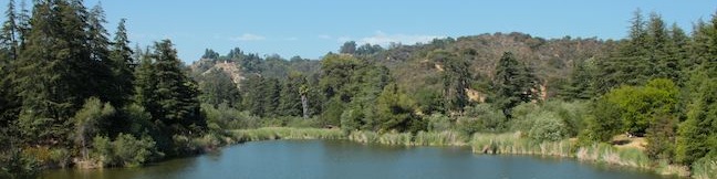
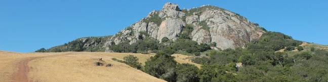
Are you looking for a hike that's an action-packed adventure? Rarely does a 2.1-mile loop offer as much excitement as the hike to the Cave of Munits and Castle Peak. You'll start with a gradual warm-up across El Escorpion Park to Upper Las Virgenes Open Space Preserve to find a fun vertical cave just begging to be explored. You won't need any ropes or gear to get through the cave, just an adventurous spirit that will lead you out the top of the cave to a tough off-trail ascent to Castle Peak, a panoramic summit towering over the west end of the San Fernando Valley. ...Read more.
Distance: 2.1 miles · Elevation change: 725 feet
By: Published: August 24, 2013 Last updated: December 6, 2025
Deane Dana Friendship Park on Palos Verdes Peninsula
Perched atop a hill on the south side of Palos Verdes Peninsula, Deane Dana Friendship Park offers hikers panoramic ocean views on an easy 1.1-mile loop. While exploring the 123-acre park, the hike gains 200 feet to views west across the Pacific Ocean toward Catalina Island and around the south end of the peninsula toward Long Beach Harbor to the east. ...Read more.
Distance: 1.1 miles · Elevation change: 200 feet
By: Published: August 22, 2013 Last updated: April 9, 2026
Old Youth Camp Loop in Stough Canyon in the Verdugo Mountains
Old Youth Camp Loop presents a short hike and a decent workout to the cool ruins of an abandoned and burned down camp in the Verdugo Mountains. In addition to the old camp, the 2.6-mile loop with 700 feet of elevation gain passes an overlook with broad views over the San Fernando Valley and several other scenic spots. The hike begins from the Stough Canyon Trailhead, where there is a nature center for another environmental experience. ...Read more.
Distance: 2.6 miles · Elevation change: 700 feet
By: Published: August 16, 2013 Last updated: April 8, 2026
Skyline Motorway in the Verdugo Mountains
Within the Verdugo Mountains, the small mountain range north of Burbank, you'll find a big league suburban hike up an abandoned fire road called Skyline Motorway. Skyline Motorway should probably be renamed Skyline Trail since the overgrown track is no longer suitable for vehicles. The Skyline half of the name is still quite valid though, as the trail presents sensational sights over the skyline of downtown Los Angeles (as well as Glendale, Studio City, and Burbank). ...Read more.
Distance: 6.1 miles · Elevation change: 1625 feet
By: Published: August 12, 2013 Last updated: April 9, 2026
El Cariso Campground in the Santa Ana Mountains
El Cariso Campground is a 24-site campground in the Santa Ana Mountains near the intersection of Ortega Highway (Route 74) and Main Divide Road on the border between Orange County and Riverside County. At 2,600 feet above sea level, the campground straddles a scenic mountain pass and can be reached easily from Lake Elsinore to the east or San Juan Capistrano to the west. ...Read more.
By: Published: August 2, 2013 Last updated: April 9, 2026
El Cariso Nature Trail in the Santa Ana Mountains
El Cariso Nature Trail is a self-guided hike in the Santa Ana Mountains, beautifully situated on the range's main divide straddling the border of Orange and Riverside counties. The 1.35-mile loop is lined with small panels that identify and describe the area's plants. Starting just off Ortega Highway, at 2,600 feet above sea level, the short loop presents excellent views across the range. ...Read more.
Distance: 1.35 miles · Elevation change: 125 feet
By: Published: August 2, 2013 Last updated: December 5, 2025
Franklin Canyon Lake Loop and Chaparral Trail in Franklin Canyon Park
No doubt LA is a busy city, but you can still find calm within the chaos at Franklin Canyon Park. This 605-acre park is tucked into a canyon in the Santa Monica Mountains in Beverly Hills and has a number of trails that allow Angelinos to escape for a couple hours of exercise in nature. North of Hastain Trail (where you can get more of a workout), you will find Upper Franklin Canyon Reservoir (Franklin Canyon Lake), a soothing 3-acre lake joined by an add-on called Heavenly Pond. ...Read more.
Distance: 2.5 miles · Elevation change: 325 feet
By: Published: July 27, 2013 Last updated: April 6, 2026
Felsman Loop Trail in San Luis Obispo
Bishop Peak rises high over San Luis Obispo and there is nothing it overshadows more than Felsman Loop Trail. This 2.7-mile loop in Bishop Peak Natural Reserve crosses oak, sagebrush, and grass-covered slopes around the base of Bishop Peak, providing excellent views of that notable rocky summit and its San Luis Obispo surroundings. Felsman Loop Trail can be combined with Bishop Peak Trail for a 5. ...Read more.
Distance: 2.7 miles · Elevation change: 525 feet
By: Published: July 16, 2013 Last updated: December 5, 2025
San Jacinto Peak via Marion Mountain Trail in the San Jacinto Mountains
San Jacinto Peak is one of the true crowns of Southern California and is a crowning achievement for any hiker who reaches the summit. San Jacinto Peak is the second highest mountain in Southern California and the pinnacle of the San Jacinto Mountain Range at 10,834 feet above sea level. Hikers who spar with San Jacinto Peak should be prepared for an all day challenge. ...Read more.
By: Published: July 8, 2013 Last updated: April 10, 2026
Ernie Maxwell Scenic Trail in the San Jacinto Mountains
The San Jacinto Mountains are a steep rugged mountain range full of challenging trails that put hikers to the test... Ernie Maxwell Scenic Trail is not one of those trails. This leisurely alternative is 5.2 miles round trip with 675 rolling feet of elevation change. The gradual and enjoyable dirt single track overlooks the mountain community of Idyllwild and is appropriate for hikers of all abilities. ...Read more.
Distance: 5.2 miles · Elevation change: 675 feet
By: Published: July 3, 2013 Last updated: April 11, 2026