Hedge Creek Falls Trail Dunsmuir California Mount Shasta Waterfall Hike
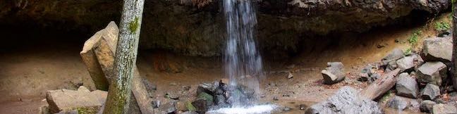
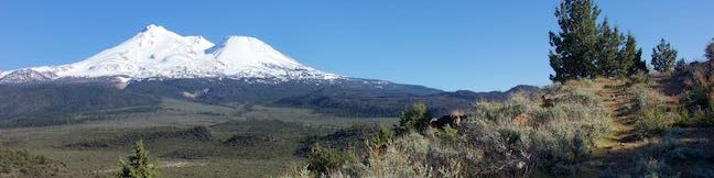
Hedge Creek Falls is a 35-foot waterfall pouring over a basalt overhang into a wooded ravine above the Sacramento River south of Mount Shasta. A short trail leads to the waterfall from a trailhead right beside an Interstate 5 offramp in Dunsmuir, so this waterfall hike makes a great break from highway travel. The fun trail actually passes behind the waterfall, going underneath the overhang, and continues down to a Sacramento River Overlook, resulting in a never-a-dull-moment 0. ...Read more.
My Hikes: Completed hikeA green icon of shows a picture of a landscape with a check mark in the upper right corner, signifying that this is a hike you would like to put on your completed list.OK! Add to trails I've hiked
My Hikes: Want to hikeA green icon of shows a picture of a landscape with a heart in the upper right corner, signifying that this is a hike you would like to put on your to-do list.OK! Add to trails I want to hike
TagsA green icon depicting a tags represents a list of words and phrases that this content is tagged with Tagged with · Dunsmuir · Free Trails · Mount Shasta · Waterfalls
Hike DistanceA green icon of a hiker used to label information about the length of the hike Distance: 0.6 miles · Elevation change: 130 feet
By: Published: Last updated: February 4, 2019
Haystack Trail Mount Shasta Hike Klamath National Forest The Haystack Butte California
The Haystack is a diminutive volcanic dome with great views of the enormous, snowy mass of Mount Shasta. Haystack Trail presents a 2.55-mile lollipop loop hike that tours the Haystack's summit plateau, boasting broad views in all directions that include Mount Shasta, the Klamath Mountains, and Shasta Valley. This high desert hike passes through juniper and sage that get embellished by spring wildflowers like lupines and Indian paintbrush. ...Read more.
My Hikes: Completed hikeA green icon of shows a picture of a landscape with a check mark in the upper right corner, signifying that this is a hike you would like to put on your completed list.OK! Add to trails I've hiked
My Hikes: Want to hikeA green icon of shows a picture of a landscape with a heart in the upper right corner, signifying that this is a hike you would like to put on your to-do list.OK! Add to trails I want to hike
TagsA green icon depicting a tags represents a list of words and phrases that this content is tagged with Tagged with · Buttes · Free Trails · Klamath National Forest · Montague · Mount Shasta · Weed
Hike DistanceA green icon of a hiker used to label information about the length of the hike Distance: 2.55 miles · Elevation change: 375 feet
By: Published: Last updated: February 4, 2019
Yurok Loop Trail Hidden Beach Hike California Coastal Trail Redwood National Park Klamath Lagoon Creek Picnic Area
Up near the Oregon border, the north coast of California has beautiful unrefined features like driftwood-covered coves and mossy forests. Explore this inviting area on Yurok Loop Trail, a short hike through scenic surroundings. This 1.15-mile circuit passes an ocean vista along a dramatic coastline that faces a cluster of rock islands. The loop crosses a small wooded ridge, overlooking a lagoon. ...Read more.
My Hikes: Completed hikeA green icon of shows a picture of a landscape with a check mark in the upper right corner, signifying that this is a hike you would like to put on your completed list.OK! Add to trails I've hiked
My Hikes: Want to hikeA green icon of shows a picture of a landscape with a heart in the upper right corner, signifying that this is a hike you would like to put on your to-do list.OK! Add to trails I want to hike
TagsA green icon depicting a tags represents a list of words and phrases that this content is tagged with Tagged with · Beaches · California Coastal Trail · Crescent City · Free Trails · Klamath · Ocean Views
Hike DistanceA green icon of a hiker used to label information about the length of the hike Distance: 2.25 miles · Elevation change: 120 feet
By: Published: Last updated: May 13, 2025
Drury-Chaney Loop Trail Hike Humboldt Redwoods State Park California
Drury-Chaney Loop Trail (also known simply as Drury-Chaney Trail) presents a easy and well graded hike through redwoods in Humboldt Redwoods State Park. The trail is a lollipop loop suitable for wheelchairs and strollers, crossing a surface of compact gravel with 100 feet of elevation change. The 2.4-mile length of this hike splits neatly into three sections: a 0. ...Read more.
My Hikes: Completed hikeA green icon of shows a picture of a landscape with a check mark in the upper right corner, signifying that this is a hike you would like to put on your completed list.OK! Add to trails I've hiked
My Hikes: Want to hikeA green icon of shows a picture of a landscape with a heart in the upper right corner, signifying that this is a hike you would like to put on your to-do list.OK! Add to trails I want to hike
TagsA green icon depicting a tags represents a list of words and phrases that this content is tagged with Tagged with · California State Parks · Free Trails · Humboldt Redwoods State Park · Pepperwood · Redwood Groves
Hike DistanceA green icon of a hiker used to label information about the length of the hike Distance: 2.25 miles · Elevation change: 120 feet
By: Published: Last updated: April 1, 2017
Grieg-French-Bell Trail Girdled Tree Hike Humboldt Redwoods State Park California
Grieg-French-Bell Trail provides access to lovely grove of coast redwoods in Humboldt Redwoods State Park. The ground in this area is covered by a carpet of redwood sorrel that is incredibly beautiful to walk through. Within French Grove, you'll find the Girdled Tree, which had its bark removed to 1901 so that it could be displayed in San Francisco. ...Read more.
My Hikes: Completed hikeA green icon of shows a picture of a landscape with a check mark in the upper right corner, signifying that this is a hike you would like to put on your completed list.OK! Add to trails I've hiked
My Hikes: Want to hikeA green icon of shows a picture of a landscape with a heart in the upper right corner, signifying that this is a hike you would like to put on your to-do list.OK! Add to trails I want to hike
TagsA green icon depicting a tags represents a list of words and phrases that this content is tagged with Tagged with · California State Parks · Free Trails · Humboldt Redwoods State Park · Pepperwood · Redwood Groves
Hike DistanceA green icon of a hiker used to label information about the length of the hike Distance: 0.5 miles · Elevation change: 25 feet
By: Published: Last updated: April 1, 2017
Castle Lake Campground Shasta-Trinity National Forest Mount Shasta Camping
Find this cozy six-site campground set within a forest of pines and other conifers near Castle Lake, a beautiful glacial cirque lake in Shasta-Trinity National Forest. Castle Lake Campground makes a convenient base camp for hikes leaving from Castle Lake and the campground is a 20-minute drive from the city of Mount Shasta along Interstate 5. Castle Lake Campground The six sites at Castle Lake Campground are located along a rough unpaved loop road that has steep sections unsuitable for trailers and RVs. ...Read more.
TagsA green icon depicting a tags represents a list of words and phrases that this content is tagged with Tagged with · Klamath Mountains · Lakes · Shasta-Trinity National Forest · Tent Camping
By: Published: Last updated: February 4, 2019
Castle Peak Hike Castle Peak Route Castle Peak Trail Heart Lake Hike Shasta-Trinity National Forest California
The short hike from Castle Lake to Heart Lake explores a scenic part of Shasta-Trinity National Forest near Mount Shasta. The fun doesn't need to stop once you reach that endearing lake. Hike off trail up a ridge from Heart Lake to a summit with extraordinary views that has been given the unofficial name of Castle Peak. You will feel like royalty when you stand on this mountaintop, taking in a bold perspective of the Castle Crags and at least three snow-capped volcanoes (Mount Lassen, Mount Shasta, and Mount McLoughlin) while also looking down over Heart Lake and Castle Lake. ...Read more.
My Hikes: Completed hikeA green icon of shows a picture of a landscape with a check mark in the upper right corner, signifying that this is a hike you would like to put on your completed list.OK! Add to trails I've hiked
My Hikes: Want to hikeA green icon of shows a picture of a landscape with a heart in the upper right corner, signifying that this is a hike you would like to put on your to-do list.OK! Add to trails I want to hike
TagsA green icon depicting a tags represents a list of words and phrases that this content is tagged with Tagged with · Klamath Mountains · Lakes · Shasta-Trinity National Forest
Hike DistanceA green icon of a hiker used to label information about the length of the hike Distance: 3.2 miles · Elevation change: 1180 feet
By: Published: Last updated: May 13, 2025
Heart Lake Trail Little Castle Lake Trail Heart Lake Hike Shasta-Trinity National Forest California
You are bound to fall in love with the hike to Heart Lake. This pint-sized heart-shaped attraction in the Castle Crags Wilderness of Shasta-Trinity National Forest boasts views of Mount Shasta, Black Butte, and surrounding Klamath Mountains. The hike to Heart Lake begins from a trailhead at Castle Lake, a larger mountain lake wrapped by pines and granite cliffs. ...Read more.
My Hikes: Completed hikeA green icon of shows a picture of a landscape with a check mark in the upper right corner, signifying that this is a hike you would like to put on your completed list.OK! Add to trails I've hiked
My Hikes: Want to hikeA green icon of shows a picture of a landscape with a heart in the upper right corner, signifying that this is a hike you would like to put on your to-do list.OK! Add to trails I want to hike
TagsA green icon depicting a tags represents a list of words and phrases that this content is tagged with Tagged with · Klamath Mountains · Lakes · Shasta-Trinity National Forest
Hike DistanceA green icon of a hiker used to label information about the length of the hike Distance: 2.9 miles · Elevation change: 645 feet
By: Published: Last updated: May 13, 2025
Antlers Campground Shasta-Trinity National Forest Shasta Lake Camping
Below pines and oaks beside Shasta Lake, you'll find Antlers Campground. The campground is conveniently located just off Interstate 5 between Redding and Mount Shasta, but you won't hear much freeway noise (actually you'll hear more noise from jet skies and boaters enjoying the Sacramento Arm of Shasta Lake). The shaded campground is spread out on a series of loops over level terrain that offers ideal spots for tent camping and immediate access to lake views. ...Read more.
TagsA green icon depicting a tags represents a list of words and phrases that this content is tagged with Tagged with · Shasta Lake · Shasta-Trinity National Forest · Tent Camping
By: Published: Last updated: January 2, 2018
Bailey Cove Trail Shasta Lake Hike Shasta-Trinity National Forest California
Bailey Cove Trail follows an easy path that weaves along the edges of a roughly triangle-shaped peninsula extends into Shasta Lake. A hill rises over the center of the peninsula, which is framed by finger-like coves on two sides. Lake views are present throughout this 3.1-mile hike and are grandest during the second mile. Bailey Cove Trail is fairly level, with just 50 feet of elevation change. ...Read more.
My Hikes: Completed hikeA green icon of shows a picture of a landscape with a check mark in the upper right corner, signifying that this is a hike you would like to put on your completed list.OK! Add to trails I've hiked
My Hikes: Want to hikeA green icon of shows a picture of a landscape with a heart in the upper right corner, signifying that this is a hike you would like to put on your to-do list.OK! Add to trails I want to hike
TagsA green icon depicting a tags represents a list of words and phrases that this content is tagged with Tagged with · Lakes · Shasta-Trinity National Forest
Hike DistanceA green icon of a hiker used to label information about the length of the hike Distance: 3.1 miles · Elevation change: 50 feet
By: Published: Last updated: April 23, 2017