Summit Valley Edmund D. Edelman Park in the Santa Monica Mountains
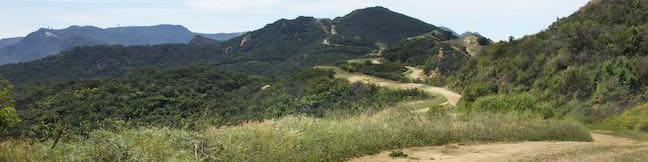
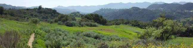
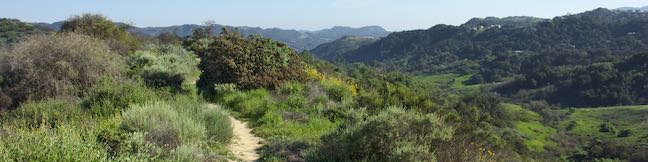
Summit Valley Edmund D. Edelman Park preserves 652 acres at the top of Topanga Canyon that were saved from development. Hikers can explore a couple loops through the main area of the park. For a short 1.65-mile hike with 190 feet of elevation change, try Edelman North Loop, which goes along the valley floor before circling back along a wildflower-covered ridge. ...Read more.
Distance: 1.65 miles · Elevation change: 190 feet
By: Published: April 12, 2015 Last updated: April 8, 2026
Calabasas Peak via Calabasas Peak Motorway from Old Topanga Canyon Road in the Santa Monica Mountains
Also known as Calabasas Peak Trail, Calabasas Peak Motorway is a 3.8-mile long dirt fire road that passes below the summit of Calabasas Peak. Hikers on the trail can examine interesting sandstone rock formations on and around Calabasas Peak and enjoy broad views over a scenic part of the Santa Monica Mountains between Topanga and Agoura Hills. One way to reach the summit of Calabasas Peak is to hike from the northeast end of Calabasas Peak Motorway where the fire road meets Old Topanga Canyon Road at the top of the valley west of Topanga. ...Read more.
Distance: 4.2 miles · Elevation change: 635 feet
By: Published: April 9, 2015 Last updated: April 9, 2026
Viewridge Trail and Summer Hill Ranch Road in Summit Valley Edmund D. Edelman Park in the Santa Monica Mountains
Viewridge Trail doesn't look like much at first glance – a one-mile long single track connecting two roads. However, there is a loop beyond the end of Viewridge Trail that reaches an overlook on sandstone outcroppings with panoramic views over Topanga and the middle of the Santa Monica Mountains. This addition elevates Viewridge Trail, and the trail it reaches called Summer Hill Ranch Road, into a very worthy hike in Summit Valley Edmund D. ...Read more.
Distance: 3 miles · Elevation change: 225 feet
By: Published: April 6, 2015 Last updated: December 5, 2025
La Tuna Canyon Trail in the Verdugo Mountains
La Tuna Canyon Trail explores a pair of canyon on the northwest side of the Verdugo Mountains between Burbank and Sunland. There are views north toward the San Gabriels and west toward the San Fernando Valley from this dirt trail as it ascends 975 feet over 2.25 miles on a winding route through the 1,100 acres of La Tuna Canyon Park. At the top, there is a bench offering relaxing views and a junction with Verdugo Fire Road, the main trail across the top of the range, which allows you to explore even farther. ...Read more.
Distance: 4.5 miles · Elevation change: 975 feet
By: Published: January 27, 2015 Last updated: April 9, 2026
Portuguese Bend Reserve on Palos Verdes Peninsula
Portuguese Bend Reserve is a 399-acre park on Palos Verdes Peninsula with an elaborate network of trails covering beautiful ocean-facing hillsides, canyons, and ridges. With so many trails, several hikes in the park are possible, including the 5.15-mile trek described here, made up of two loops. For something shorter, skip the lower loop for a 3-mile round trip hike with 575 feet of elevation change (the longer double-loop has 975 feet of elevation change). ...Read more.
Distance: 5.15 miles · Elevation change: 975 feet
By: Published: December 11, 2014 Last updated: April 9, 2026
Ultimate Destination Vista Point and Lookout Tower in Cherry Canyon Park
Cherry Canyon Park preserves over 130 acres in the San Rafael Hills, a small mountain range east of the Verdugo Mountains and south of the San Gabriel Mountains in the city of La Cañada Flintridge. The park has many trails, including wide fire roads suitable for horses and mountain bikes and single tracks strictly for hikers. For a good overview of the area, consider hiking to an old lookout tower at the high point of the park along with Ultimate Destination Vista Point, which offers a panoramic view east over the San Gabriel Valley and north toward the grand San Gabriel Mountains. ...Read more.
Distance: 2.5 miles · Elevation change: 500 feet
By: Published: October 7, 2014 Last updated: April 8, 2026
Trails to the Hollywood Sign in Griffith Park
Griffith Park is full of Los Angeles landmarks like the Hollywood Sign, the Griffith Observatory, and the Greek Theater. The park includes other less-known prizes like an abandoned zoo and tropical gardens along Ferndell Trail. For those who want to hike up to the Hollywood Sign, there are four obvious routes to choose from: Hiking to the Hollywood Sign from. ...Read more.
By: Published: August 10, 2014 Last updated: April 15, 2026
Vital Link Trail in the Verdugo Mountains
With an inspired name and inspiring view, Vital Link Trail presents a rewarding hike in the Verdugo Mountains near Burbank. The trail delivers a good workout too, ascending 1,275 feet in a mile and a half, with opportunities to hike even farther. The steep single track looks out over the east end of the San Fernando Valley toward the Santa Monica Mountains and the skyscraper skyline of downtown Los Angeles. ...Read more.
Distance: 3 miles · Elevation change: 1275 feet
By: Published: June 28, 2014 Last updated: April 9, 2026
Pacific Crest Trail and Foot Trail Loop in Vasquez Rocks Natural Area Park
Vasquez Rocks Natural Area Park is a dramatic desert wonderland, with striking rock formations that point skyward at a 45-degree angle. This 932-acre Los Angeles County Park delivers a scenic desert backdrop for hikers, and is just a quick drive from LA. This pairing of unique beauty and convenience has made Vasquez Rocks a popular location for the film industry and the park has a long list of credits, including Star Trek, Blazing Saddles, and The Flintstones. ...Read more.
Distance: 3.4 miles · Elevation change: 325 feet
By: Published: January 21, 2014 Last updated: April 9, 2026
Mount Wilson Toll Road to Henninger Flats in the San Gabriel Mountains
In 1917, Mount Wilson Toll Road was used to bring equipment (including the 100-inch mirror) up to Mount Wilson Observatory where the world's largest telescope was assembled for gazing out across the universe. Today visitors can use the same dirt road to enjoy naked-eye views across the Southland. On clear days the views extend to the Palos Verdes Peninsula, framed by two slices of the Pacific Ocean, and all the way to Catalina Island. ...Read more.
Distance: 6 miles · Elevation change: 1325 feet
By: Published: December 7, 2013 Last updated: April 10, 2026