Amboy Crater in Mojave Trails National Monument
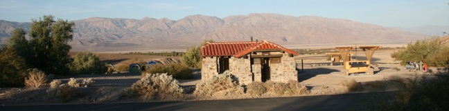
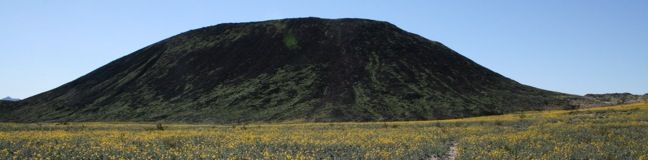
Amboy Crater is nestled halfway between Barstow and Needles, just off historic Route 66. It is located near, but not within, Mojave National Preserve. A visit to Amboy Crater will definitely take you back in time. Ten thousand years ago, this cinder cone volcano erupted, transforming the surrounding landscape. A 3-mile round trip trail leads up and into the crater, connecting to a path around the rim that provides startling views. ...Read more.
Distance: 3 miles · Elevation change: 275 feet
By: Published: February 10, 2010 Last updated: December 6, 2025
Golden Canyon – Gower Gulch Loop in Death Valley National Park
Golden Canyon - Gower Gulch Loop visits some of the most stunning landscapes in Death Valley National Park. The 4-mile hike begins with a one-mile trek up Golden Canyon. Numbered markers along the way make the canyon easy to follow. These markers correspond with an interpretive trail guide that tells the geological history of the land. The guide is available for purchase at the trailhead and visitor centers, but no guide is required to realize the beauty of Golden Canyon. ...Read more.
Distance: 4 miles · Elevation change: 675 feet
By: Published: February 9, 2010 Last updated: April 8, 2026
Badlands Loop in Death Valley National Park
Badlands Loop offers a great immersion into the terrain beneath Zabriskie Point in Death Valley National Park. This 2.5-mile hike is all badlands. Anyone who hiked the Golden Canyon - Gower Gulch Loop and enjoyed the middle section of the trek will love the Badlands Loop. The trail starts down an obvious gully just north of the Zabriskie Point parking lot. ...Read more.
Distance: 2.5 miles · Elevation change: 300 feet
By: Published: February 9, 2010 Last updated: December 5, 2025
Zabriskie Point in Death Valley National Park
Zabriskie Point offers a stunning panorama of the badlands near Furnace Creek in Death Valley National Park. The overlook stands at the upper east end of a badlands terrain full of impressive canyons and gulches. A short walk up a paved hill is all that is required to take advantage of this amazing vantage point. The hard drought-plagued sun-baked slopes around Zabriskie Point support almost no vegetation and possess a start beauty. ...Read more.
Tagged with · National Parks
By: Published: February 9, 2010 Last updated: April 13, 2026
Twenty Mule Team Canyon in Death Valley National Park
Just up the road from Zabriskie Point in Death Valley National Park is a canyon that can be experienced right from the driver's seat. This 2.8-mile one-way dirt road is well maintained and passable in any car or truck. The road leads into and across a picturesque Death Valley landscape of canyons and badlands. The scenery is impressive, plus the kids in the backseat can play a game of who-can-spot-the-most-borax-mine-shafts along the way. ...Read more.
Tagged with · National Parks
By: Published: February 9, 2010 Last updated: April 13, 2026
Camping in Death Valley National Park
Nine campgrounds are open to visitors within the boundaries of Death Valley National Park. Texas Spring Campground near Furnace Creek is centrally located and one of the nicer campgrounds in Death Valley, with bushes and short trees providing shade. Some of the other campgrounds are not California's most impressive, offering little more than open gravel landscapes for setting up tents. ...Read more.
Tagged with · National Parks · Tent Camping
By: Published: February 8, 2010 Last updated: April 9, 2026
Artist’s Drive in Death Valley National Park
Artist's Drive crosses a sloping mountainside composed of vibrant soil colored by rich metals. The drive passes an area dubbed the Artist's Palette, which is among the unique landmarks in Death Valley National Park that must be seen to believe. Artist's Drive is a one-way road traveling from south to north. For those coming from Badwater Basin, this is an ideal side trek en route to Furnace Creek. ...Read more.
Tagged with · National Parks
By: Published: February 5, 2010 Last updated: April 13, 2026
Natural Bridge Canyon in Death Valley National Park
The 2-mile round trip hike up Natural Bridge Canyon is a great trek for those interested in learning about the geological history of Death Valley National Park. Also, the natural bridge is just cool to walk under. A panel at the trailhead provides illustrations of the various geological features visible in the canyon, making it easy for hikers to spot the faults, chutes, and mud drippings along the way. ...Read more.
Distance: 2 miles · Elevation change: 400 feet
By: Published: February 5, 2010 Last updated: December 5, 2025
Badwater Basin in Death Valley National Park
Badwater Basin is a must-stop on any first trip to Death Valley National Park. The elevation here is -282 feet, making this the lowest locale in North America. A wooden Sea Level plaque 282 feet over Badwater Basin lets visitors know just how low they've come. Badwater Basin Being able to brag about how far below sea level you've been is not the only reason to stop at Badwater Basin. ...Read more.
Tagged with · National Parks
Distance: 1 mile · Elevation change: 10 feet
By: Published: February 5, 2010 Last updated: December 5, 2025
Dante’s View in Death Valley National Park
Dante's View is the primary overlook in Death Valley National Park because it offers premier panoramic views. Below Dante's View is Badwater Basin, the lowest point in North America. Across the valley rises Telescope Peak, the highest in the park. Under the morning light, the views are breathtaking in every direction. It feels like cheating to be able to drive right up to such amazing views. ...Read more.
Tagged with · National Parks
Distance: 1 mile · Elevation change: 200 feet
By: Published: February 5, 2010 Last updated: April 19, 2026