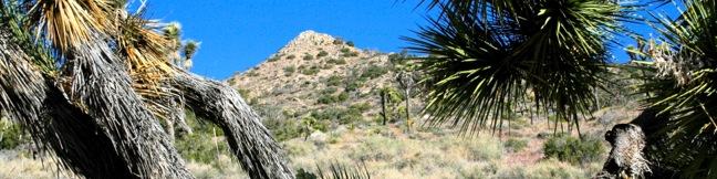
Arch Rock in Joshua Tree National Park
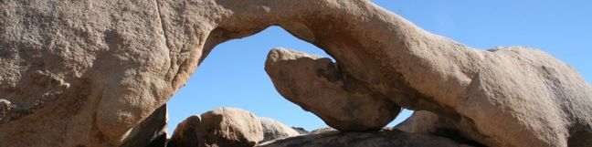
Want to see a natural arch in Joshua Tree National Park? Take a short hike to Arch Rock within the granite formations surrounding White Tank Campground. An easy and enjoyable 0.3-mile loop leaving the campground is a must-do stroll for anyone staying at White Tank Campground. Other park visitors can now enjoy a 1.3-mile lollipop loop hike that begins from a trailhead along Pinto Basin Road. ...Read more.
Tagged with · Arches · National Parks · Nature Trails
Distance: 1.3 miles · Elevation change: 100 feet
By: Published: December 3, 2010 Last updated: April 10, 2026
Darwin Falls in Death Valley National Park
Darwin Falls should not be part of Death Valley National Park. In fact, the year-round waterfall does not belong in the California desert at all. The hike starts as innocently as so many nearby trails, at the mouth of a gravel-bottom canyon, but after 0.7 miles the canyon closes and the trail enters a lush oasis of cottonwoods and willows. The next 0. ...Read more.
Distance: 2 miles · Elevation change: 275 feet
By: Published: May 25, 2010 Last updated: December 5, 2025
Sidewinder Canyon in Death Valley National Park
Sidewinder Canyon is located at the base of the Black Mountains on the east side of Death Valley National Park south of Badwater Basin. The canyon is fairly wide with a gravel bottom and forty-foot stone walls on both side. Within these walls lie tight slot canyons with pour-overs, carve outs, and dark passages that beg to be explored. There are three slot canyons off the south wall of the canyon and other slightly wider side canyons worth experiencing. ...Read more.
Distance: 7 miles · Elevation change: 750 feet
By: Published: May 24, 2010 Last updated: April 19, 2026
Ashford Mill in Death Valley National Park
The Ashford Mill ruins are visible to those driving up route 178 to Badwater Basin and Furnace Creek in Death Valley National Park. The ruins rest on the valley floor at an elevation of 121 feet below sea level. They serve as a picturesque example of the rigors of life in this harsh desert. In 1914, Ashford Mill was built to process gold from the Ashford Mine, located in the mountains to the east. ...Read more.
Tagged with · Mines · National Parks · Ruins
By: Published: May 24, 2010 Last updated: April 15, 2026
Wildrose Peak in Death Valley National Park
Wildrose Peak resides on the northern end of a group of peaks that form the top of the Panamint Mountain Range, which runs down the west side of Death Valley National Park. The 9,064-foot peak is about seven miles north of Telescope Peak, the highest point in the park at 11,049 feet. Wildrose sports an expansive view of the Panamint Mountains, Badwater Basin, and the surrounding desert landscape. ...Read more.
Tagged with · National Parks · Summits
Distance: 8.4 miles · Elevation change: 2200 feet
By: Published: May 22, 2010 Last updated: April 18, 2026
Charcoal Kilns in Death Valley National Park
The Charcoal Kilns are a well-preserved attraction in Death Valley National Park. These conical constructions converted lumber to charcoal from 1879 to 1882. During that period, workers burnt logs in these giant airtight ovens, pyrolyzing pine to charcoal, which was then hauled to the nearby Modock Mine smelter. The coal-making process took about two weeks. ...Read more.
Tagged with · National Parks
By: Published: May 22, 2010 Last updated: April 13, 2026
Petroglyphs on North Lava Bed Wash near Seventeen Mile Point in Mojave National Preserve
Visitors driving though Mojave National Preserve between Baker and Kelso Depot may wish to stop near Seventeen Mile Point for a quick walk to simple petroglyphs drawn into the volcanic rock outcroppings along the road. While certainly not the only petroglyphs in the preserve, these might be the easiest to get to. A petroglyph engraved into the rock On Kelbaker Road, 13. ...Read more.
Tagged with · Free Trails · Lava · Petroglyphs
Distance: 0.25 miles · Elevation change: 25 feet
By: Published: May 19, 2010 Last updated: December 5, 2025
Silver Peak in Mojave National Preserve
This 8.5-mile hike ascends 2,500 feet to summit a 6,365-foot peak in the small range of mountains in the southwestern corner of Mojave National Preserve. Silver Peak looks out across the Granite Mountains toward the Kelso Dunes, Cima Dome, and the peaks of the Providence Range - a worthy view of Mojave National Preserve to be sure. Nearby Granite Peak is the tallest mountain in the range (6,762 feet), but Silver Peak is an easier hike because there is a rough trail leading almost all the way to the summit. ...Read more.
Tagged with · Closed · Free Trails · Off Trail · Summits
Distance: 8.5 miles · Elevation change: 2500 feet
By: Published: May 18, 2010 Last updated: December 5, 2025
Lava Tube in Mojave National Preserve
A field of cinder cones stands out dramatically from the surrounding Mojave Desert between the city of Baker and Kelso Depot Visitor Center in Mojave National Preserve. Within the lava field is a short trail leading to a tube formed long ago by molten lava. A ladder takes hikers down into the tube where skylights (holes in the rock ceiling) illuminate a subterranean world. ...Read more.
Tagged with · Caves · Free Trails · Lava · Lava Tubes
Distance: 0.6 miles · Elevation change: 150 feet
By: Published: May 17, 2010 Last updated: December 5, 2025
Warren Peak in Joshua Tree National Park
Warren Peak is a high point on the western edge of the Little San Bernardino Mountains in Joshua Tree National Park. Located away from Park Boulevard, Warren Peak offers private peace of mind and near endless views. A 5.5-mile round trip hike to the 5,103-foot summit begins from Black Rock Campground, the only campground in the park where visitors can sleep surrounded by Joshua trees. ...Read more.
Tagged with · National Parks · Summits
Distance: 5.5 miles · Elevation change: 1000 feet
By: Published: May 14, 2010 Last updated: December 5, 2025