Calcite Mine Trail and Narrows in Anza-Borrego Desert State Park
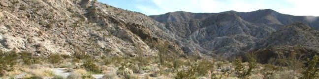
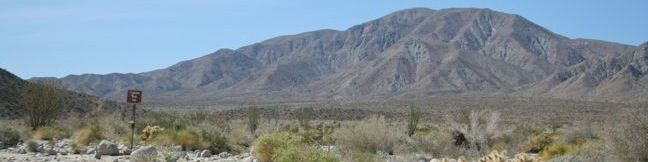
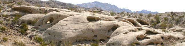
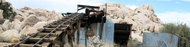
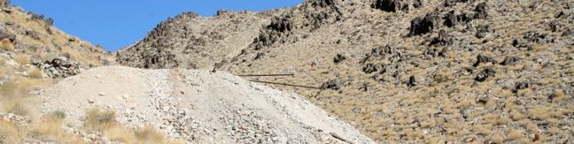
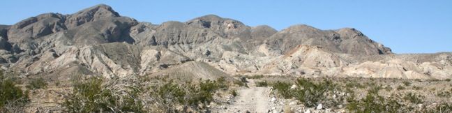
For a brief period at the start of America's involvement in World War Two, this area was heavily mined for its high-grade calcite, a mineral then used to make bomb sights. This approximately 4-mile long expedition follows an old mining road into the Santa Rosa Mountains, crossing a narrow ravine with slot canyons that hikers may explore to add variety and excitement to this trek in Anza-Borrego Desert State Park. ...Read more.
Distance: 4 miles · Elevation change: 600 feet
By: Published: March 31, 2011 Last updated: April 9, 2026
Narrows Earth Trail in Anza-Borrego Desert State Park
What Elephant Trees Trail is to desert botany, Narrows Earth Trail is to desert geology. The pamphlet available at the start of this half-mile loop describes the geological features present in Anza-Borrego Desert State Park. The desert is a great place to learn about geology. Sparse vegetation exposes the earth's rock skeleton, bringing the secrets of the land's formation to bear. ...Read more.
Distance: 0.5 miles · Elevation change: 50 feet
By: Published: March 29, 2011 Last updated: April 9, 2026
The Slot in Anza-Borrego Desert State Park
Simply named The Slot, this narrow siltstone canyon provides one of the most exciting hikes in Anza-Borrego Desert State Park. This 0.8-mike trek is capped off with a passage beneath a gravity-defying rock span. This short hike has just 100 feet of elevation loss, but the memory will be much more profound. The Slot lacks a defined trail marker. From the parking area, look for footprints leading down into the ravine below. ...Read more.
Distance: 0.8 miles · Elevation change: 100 feet
By: Published: March 23, 2011 Last updated: April 18, 2026
Elephant Trees Trail in Anza-Borrego Desert State Park
The elephant tree is likely the most unique plant in the entire Anza-Borrego Desert, and only one such tree stands along this one-mile nature trail. Pick up a pamphlet at the start of this self-guided loop, and enjoy a brief lesson on elephant trees and other more common vegetation. This is a great trail for those interested in learning about plant life in the Anza-Borrego Desert. ...Read more.
Distance: 1 mile · Elevation change: 50 feet
By: Published: March 22, 2011 Last updated: April 8, 2026
Wind Caves Trail in Anza-Borrego Desert State Park
A short hike to a fascinating destination overlooking the Carrizo Badlands begins on the far east side of Anza-Borrego Desert State Park. This 1.25-mile round trip hike climbs 250 feet to a sandstone formation with wind-eroded pockets that insist on being explored. The hike begins with a quick ascent up the east side of Split Mountain Wash. Climb a series of rocky steps. ...Read more.
Distance: 1.25 miles · Elevation change: 250 feet
By: Published: March 21, 2011 Last updated: April 9, 2026
Wildflowers in Anza-Borrego Desert State Park
Wildflowers draw crowds of visitors to Anza-Borrego Desert State Park. Who wouldn't want to see the desert come alive with vibrant tapestries of colors? At peak bloom, which lasts just a couple of weeks, the desert floor transforms into a dazzling tableau with carpets of yellow, red, and purple. The bloom typically climaxes in early march, but the intensity and timing of the bloom varies each year. ...Read more.
By: Published: March 19, 2011 Last updated: April 6, 2026
Camping in Anza-Borrego Desert State Park
There is absolutely no shortage of camping in Anza-Borrego Desert State Park. Four developed campgrounds with 175 total sites and eight primitive campgrounds with even more places to camp are located throughout the park. Primitive campgrounds are free, and sites at developed campgrounds range from fifteen to thirty-five dollars per night (and $80 for a group site at Borrego Palm Canyon Campground). ...Read more.
By: Published: March 17, 2011 Last updated: April 9, 2026
Wonderland Wash in Joshua Tree National Park
In between Barker Dam Trail and Wall Street Mill Trail is Wonderland Wash Trail, an unmaintained single track through the Wonderland of Rocks in Joshua Tree National Park. This less-traveled trail passes monzogranite mounds that are a popular playground for rock climbers and bouldering enthusiasts. There is no defined end to the trail, but a hike to the prominent rock formation known as the Astro Dome creates a rewarding 2. ...Read more.
Tagged with · Bouldering · National Parks
Distance: 2.1 miles · Elevation change: 75 feet
By: Published: December 20, 2010 Last updated: April 8, 2026
Wall Street Mill in Joshua Tree National Park
For the first half of the 20th century, the desert land now known as Joshua Tree National Park was scattered with miners on the hunt for gold and silver. When ore was mined, it was sent to a mill to be crushed and have the precious metal extracted. The ore from Desert Queen Mine and other mining operations passed through Wall Street Mill, which is located in Queen Valley near the Wonderland of Rocks. ...Read more.
Tagged with · National Parks · Ruins
Distance: 2.15 miles · Elevation change: 115 feet
By: Published: December 14, 2010 Last updated: April 13, 2026
Contact Mine in Joshua Tree National Park
Contact Mine was in operation at the start of the 20th century, extracting gold and silver from the mountains south of Twentynine Palms, California. A hundred years of desert decay have left the mine rusty but recognizable. The old road to the mine is worn down and eroded, now just a little-used hiking trail. This 3.95-mile round trip trek ascends 700 feet up a wash, a canyon, and an old road to a mountainside mine site that offers a glimpse into the mining history of Joshua Tree National Park. ...Read more.
Distance: 3.95 miles · Elevation change: 700 feet
By: Published: December 9, 2010 Last updated: April 9, 2026