Morro Dunes Ecological Reserve in San Luis Obispo
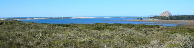
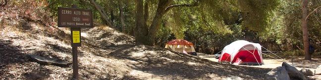
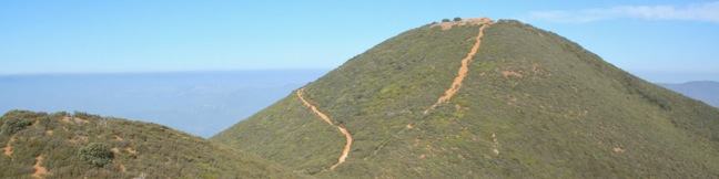
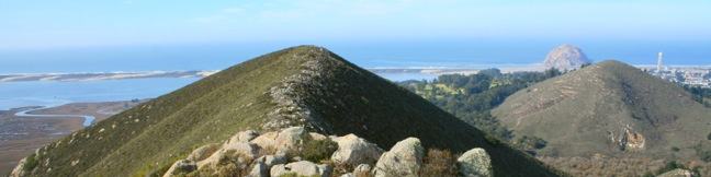
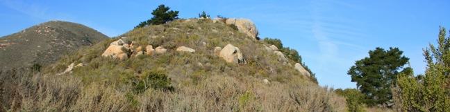
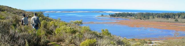
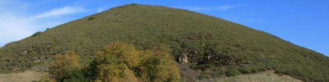
The community of Los Osos on the San Luis Obispo County coast is buffered on the south side by an ecological reserve. A 2.6-mile hike through Morro Dunes Ecological Reserve (also called Bayview Ecological Reserve) ascends 800 feet, briefly entering Montaña de Oro State Park at the trail's highest point. The loop travels over ancient sand dunes that became grown over by grasses and brush. ...Read more.
Distance: 2.6 miles · Elevation change: 800 feet
By: Published: February 27, 2012 Last updated: April 9, 2026
Elfin Forest Natural Preserve in San Luis Obispo
Elfin Forest Natural Preserve (also know as Los Osos Elfin Forest and El Moro Elfin Forest Natural Area) lies between the communities of Morro Bay and Los Osos on the coast of San Luis Obispo County. A mile of boardwalk circles the 90-acre preserve, providing opportunities to gaze across Morro Bay and admire nearby peaks in Morro Bay State Park. There is a thin 80 feet of elevation gain along the loop, making it suitable for strollers, walkers, and wheelchairs. ...Read more.
Distance: 1 mile · Elevation change: 80 feet
By: Published: February 23, 2012 Last updated: April 8, 2026
Cerro Alto Campground in San Luis Obispo
Ah, what could be finer than a night beneath the pines and oaks at a cozy campground in Los Padres National Forest? A peaceful camping experience awaits at Cerro Alto Campground, located just off Route 41 between Morro Bay and Atascadero in San Luis Obispo County. The year-round campground has 22 sites spread out along a mile-long road in an oak-shaded canyon below Cerro Alto. ...Read more.
By: Published: January 7, 2012 Last updated: April 13, 2026
Cerro Alto in San Luis Obispo
The 2,624-foot summit of Cerro Alto is one of the highest points in San Luis Obispo County and delivers a panoramic view. It seems like you can see the entire county from the top of the commanding peak, including each of the volcanic peaks stretching between Morro Bay and Edna Valley, the Nine Sisters. There are a couple ways to the summit, each tackling 1,600 feet of elevation between the trailhead at Cerro Alto Campground and the cerro's summit. ...Read more.
Distance: 5.35 miles · Elevation change: 1600 feet
By: Published: January 6, 2012 Last updated: December 9, 2025
Cerro Cabrillo and Tiki Rock in Morro Bay State Park
Nine principle volcanic plugs are spread between the central coast cities of Morro Bay and San Luis Obispo. The 911-foot Cerro Cabrillo (or Cabrillo Peak) is the third of the Nine Sisters from the west after Morro Rock and Black Hill. The summit of Cerro Cabrillo is the highest point in Morro Bay State Park, offering panoramic oceanfront views.  The unmaintained trail to the summit passes Tiki Rock, an unmistakable boulder near the top of the peak resembling those carved by Polynesians. ...Read more.
Distance: 2.5 miles · Elevation change: 900 feet
By: Published: December 30, 2011 Last updated: April 9, 2026
Turtle Rock in Morro Bay State Park
If you are looking for an easy 45-minute hike to the top of a pimple of a hill between two of San Luis Obispo's Nine Sisters, take Chorro Trail to Turtle Rock in Morro Bay State Park. This 2.1-mile round trip hike begins with views of the estuary feeding Morro Bay and ends atop a small rise between Black Hill and Cerro Cabrillo. There is only 200 feet of elevation gain along the way, making this a quick hike that can be easily connected to other trails in the park. ...Read more.
Distance: 2.1 miles · Elevation change: 200 feet
By: Published: December 29, 2011 Last updated: April 10, 2026
Portola Point in Morro Bay State Park
It can feel like stealing when you snag great views from an easy hike. This is the situation on the 2-mile loop to Portola Point in Morro Bay State Park, which ascends 315 feet to panoramic views over Morro Bay. The view-to-effort ratio on this hike is quite favorable, almost criminal. Portola Hill is a dome-shaped volcanic rise on the eastern edge of Morro Estuary. ...Read more.
Distance: 2 miles · Elevation change: 315 feet
By: Published: December 24, 2011 Last updated: December 9, 2025
Eagle Rock Nature Trail in El Chorro Regional Park in San Luis Obispo
Along Highway One between San Luis Obispo and Morro Bay, is a regional park with over 700 acres of land that were formerly part of Camp San Luis. The versatile El Chorro Regional Park sports a 63-site campground, a botanical garden, playground, picnic area, dog park, volleyball courts, ball fields, and Dairy Creek Golf Course. Additionally, the park hosts a 2. ...Read more.
Distance: 2.4 miles · Elevation change: 450 feet
By: Published: December 23, 2011 Last updated: April 8, 2026
Sydney Street Trail to Murray Hill (Unnamed Hill) in San Luis Obispo
If the hike at your own risk sign at the start of Sydney Trail doesn't intimidate you, maybe the 1,275-foot climb over 1.4 miles (one-way) will. This is a steep hike up a rocky road. The destination is a stone seating area at the top of Murray Hill (also known as Unnamed Hill), a 1,715-foot summit in the Santa Lucia Foothills with panoramic views over San Luis Obispo, more commonly reached from the north via Reservoir Canyon Trail. ...Read more.
Tagged with · Free Trails · Summits
Distance: 2.8 miles · Elevation change: 1275 feet
By: Published: December 17, 2011 Last updated: April 8, 2026
Islay Hill in San Luis Obispo
Islay Hill stands at the eastern end of the chain of volcanic plugs running across San Luis Obispo. If Bishop Peak is the most iconic Morro, than Islay Hill is about the easiest to hike (with the exception of Black Hill). The dome-shaped 776-foot summit is more mound than mountain, but you will find 550 feet of elevation gain on the 1.8-mile round trip hike to the top. ...Read more.
Tagged with · Free Trails · Morros
Distance: 1.8 miles · Elevation change: 550 feet
By: Published: December 13, 2011 Last updated: December 5, 2025